Objectives of the service
The study addresses the needs of two main stakeholders: Fisheries and Sea Authorities (enforcement). Fisheries involved so far are those making coastal fishing with small-size boats. Such fleets of relatively small vessels are recognized by the Common Fisheries Policies as the best suited to perform fishing in a sustainable manner, because of their limited impact on the sea environment. The need for better product traceability, better market prices, lower operational cost and reduction of illegal an unregulated fishing represents therefore a common ground between both stakeholders. FISHSAT can build on this, through an innovative integration of space assets with conventional information and communication technologies.
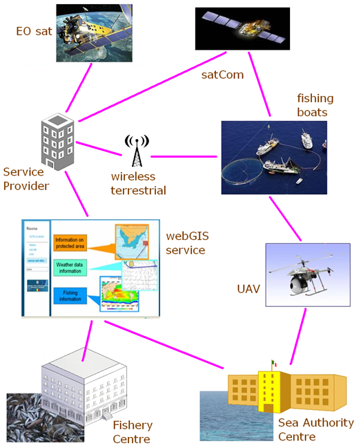
The FISHSAT feasibility study aims at designing, developing and validating a first basic prototype of a distributed system (onboard & onshore) that provides information services for more efficient, more compliant and more sustainable fishing. The study will also identify the viability (incl. legal, political, financial, technical, operational aspects) and define the business roadmap for the implementation of the FISHSAT system and its associated services towards acceptance and commercialization.
Users and their needs
- Fisheries (through their national associations)
- Sea Authorities
Service/ system concept
Improve fishing capability.
- Biological and physical sea parameters derived from EO imagery will be used to assess the presence of fish in the permitted areas. The suggestion of most productive zones should contribute to reduce the fishing effort.
Improve marketing capability.
- Data on catches will be anticipated to fishery ground centre while vessels are still at sea, in order to setup an early marketing strategy.
- A quality mark will be devised based on data acquired during the fishing session. Product traceability will account for both its healthiness and sustainability. Products will be labelled with such a mark.
Improve crew safety.
- Message exchange between shore and fisheries will be possible in case of critical situations.
Support to the respect of fishing regulation.
- The onboard system will include an electronic logbook of catches. The mandatory Catches Report will be submitted automatically to the Sea Authority ensuring compliance.
- Sea areas where fishing is forbidden will be displayed to boat crew in real time. A warning will be raised in case some illegal activity is initiated in such areas.
Improve the Sea Authority monitoring capability.
- A SatCom based AIS forwarding system installed on the fishing vessels will let the Sea Authority know also about the position of some boats whose AIS signal would be beyond reach from coast.
- Data sensed onboard about e.g. the status of net and line deployment will allow the Sea Authority to know about fishing boat behaviour. Sea temperature and other data for statistic analysis can be collected through the fishing vessels.
- Catches data recorded onboard will allow the Sea Authority to know about catch amount and type
Improve the Sea Authority capability to fight illegal fishing practices.
- In case some specific illegal practices are initiated by the boat, the Sea Authority would be informed immediately and could rely on the recorded data as a proof of crime.
- An unmanned helicopter UAV, launched from a coast guard vessel could be used to identity an unrecognized boat.
Space Added Value
- EO satellite data will be used to estimate several sea parameters and to derive meteorological information in support to conventional forecasts. Such data will support the identification of most productive regions, thus allowing a more effective catches strategy.
- Satellite communication will be used to complement terrestrial wireless technology in offshore areas, where the latter is not effective.
- GNSS - The Global Positioning Systems (possibly the future Galileo system) will be used to track vessels and to collect the geo-references for catches traceability.
Current Status
The project has kicked off in September 2011 and is now completed.
Prime Contractor(s)
Subcontractor(s)


