Objectives of the service
Grassland management and grazing of dairy cows have (re)gained interest from many stakeholders. Technology is offered in many ways to overcome current shortcomings, in particular concerning timely information needs related to day-to-day decision making.
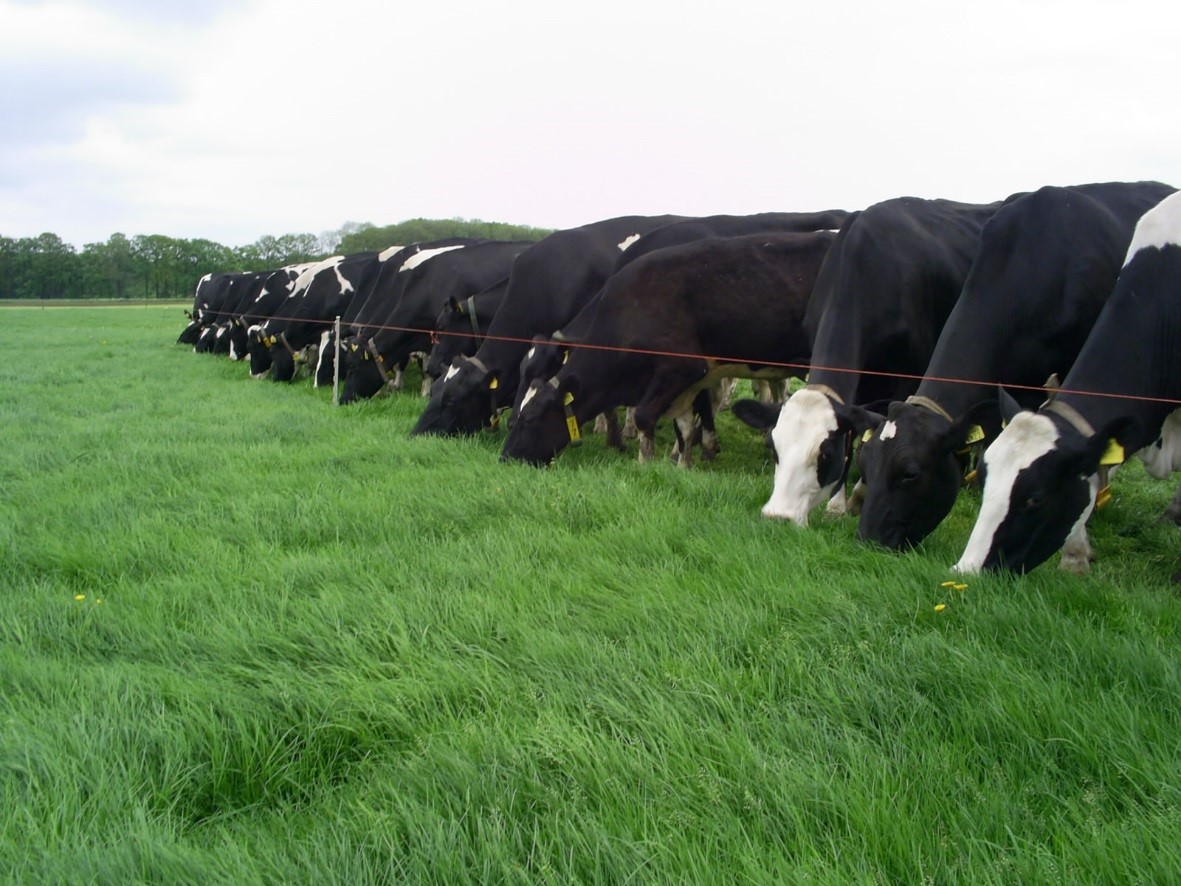
GrazingSpace fills that gap, by providing timely information on the availability of grass (biomass) for grazing and/or mowing, as well as timely information on the feeding efficiency of cows. The concept is initially developed to accommodate strip-grazing, where cows are offered a strip, a reduced area of the pasture which they will graze more intensively. Biomass information determines the estimated size of the strip, and the cow movement tracks, translated into grazing behaviour data indicate if cows are still efficiently grazing or if the next strip should be “unlocked”.
Users and their needs
The dairy farmer is the main customer and user for the GrazingSpace service. The dairy farmer manages the grazing operation deciding where cows are grazing, for how long etc. The added value and business proposition for the farmer is based on reduced efforts and costs in this grazing management.
Besides the dairy farmer, other stakeholders can be beneficiaries of the service as well, such as farm advisors, dairy companies etc.
The main user requirements are:
- Knowing the amount of available grass
- Predicting the grass growth (and crude protein)
- Knowing the amount of supplementary feed
- Knowing the fresh grass uptake by cows
- Ensuring that cows have grazed
The Netherlands
Service/ system concept
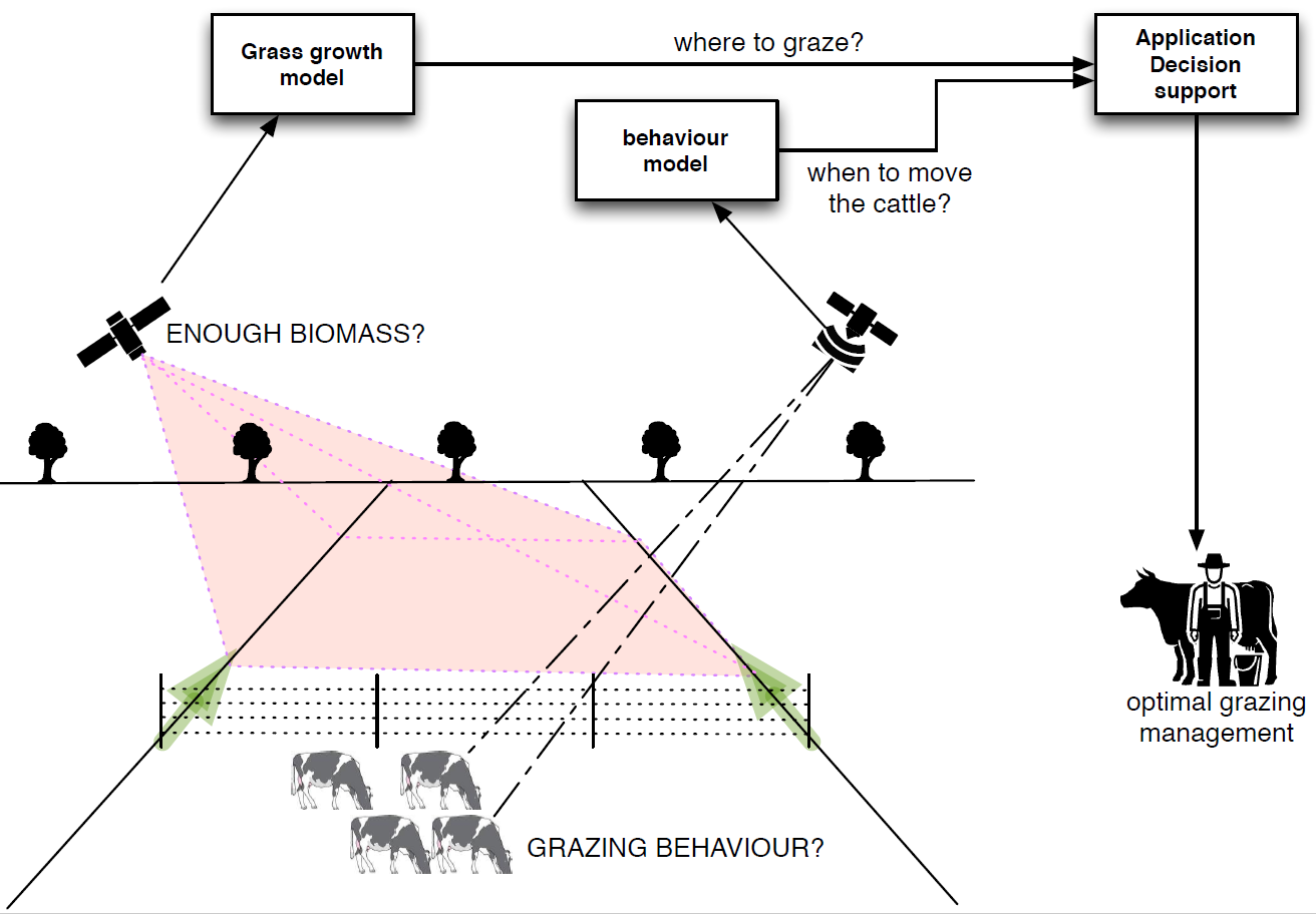
GrazingSpace is a satellite based information service combining GNSS based animal tracking of individual cows with monitoring of grassland through Earth Observation (EO) satellite data.
With GrazingSpace, farmers can make informed decisions on pasture management and cow management to increase sustainability and profit. GrazingSpace capitalises on existing solutions, such as calculating biomass from NDVI and the use of a grass growth model to assess the amount of grass as well as solutions to use GPS and accelerometers to measure cow behaviour and integrates them into an information system to optimise the grassland use on dairy farms.
With this information, farmers can decide when and how far they move their fence(s) that presents fresh grassland to the cows. GrazingSpace translates satellite data into value added information, that when aligned with existing farm systems and technology is to become an integrated grazing management system.
Space Added Value
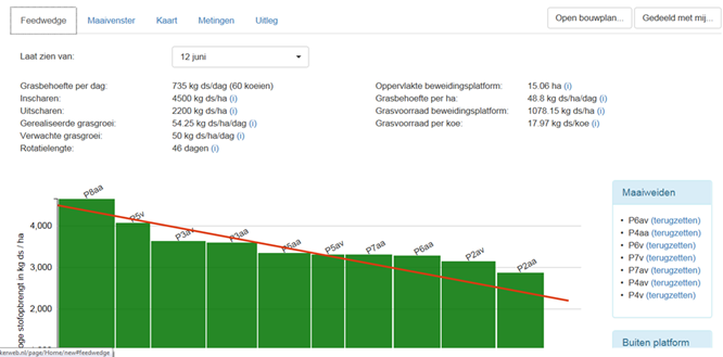
The biomass estimation of grassland is based on a grassland model that is fed with satellite based biomass estimates, or vegetation index maps. The model can compute projected growth and as such indicate when the pasture can be grazed (or mowed). A service to provide dairy farmers with this information is technically, scientifically and methodologically feasible. It resembles similar approaches in arable farming, with the exception that grassland is a continuous crop with multiple (but smaller) harvests and two harvest types: mowing and grazing. The envisaged application is an ordered list of pastures, ranked on accumulated biomass, such as a feedwedge (see Figure 2), so the farmer knows which field is most suitable for grazing at that moment.
The grazing behaviour is based on measuring spatial activity patterns of the cows by using a GNSS receiver. A 3D-accelerometer sensor enhances the spatial patterns with additional information on specific movements. The combined sensor measures walking, grazing, laying (ruminating) and standing activities. The sequence of activity types indicates if and how behavioural attitudes are adapting to changing environments. All information gathered is reduced into a single signal indicating that the cow is not (no longer) making optimal intake from its grazing and has to be moved to a new strip.
Current Status
The feasibility study was completed in October 2017 and it showed that information can be retrieved from satellite data for biomass estimations as well as for measuring cow behaviour. The feasibility study also showed that in order to obtain the information for an operational setting on the dairy farm, the service needs to be further elaborated. Critical points are the gapless supply of EO imagery and the information extraction from movement data.
At this point of time, to build a commercial service for dairy farmers the operational aspects are still too complex, uncertain and expensive to proceed. Expectations are that these technical / operational aspects can be resolved, although the timing of those breakthroughs is difficult to assess, hence a considerable risk for GrazingSpace.
The consortium aims to engage in a demonstration project with additional participation of parties covering the full value chain, either as partner or as supplier. In order to achieve this, the required R&D activities need to be started and additional parties need to be engaged.
Prime Contractor(s)
Subcontractor(s)