Objectives of the service
This demonstration project constructs a pre-operational system for end users which optimises the handling of intermodal freight transport through European ports. The optimisation is realised by providing more visibility to the different actors involved in freight transport. The I-PORT services are defined to match user needs and expectations, with results being measured against customer developed success criteria.
The project provides I-PORT services to the supporting stakeholders in an operational environment, gathering user validation comments, which are used to refine the services in preparation for an operational roll out.
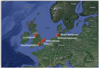
Implementation of the demonstrator takes place in six European Ports; Liverpool, Southampton, Bremerhaven, Felixstowe, Wilhelmshaven and London (Tilbury), providing sufficient scale to be able to fully evaluate the potential for a commercial system implementation.
The project deliverables are designed to enable roll out immediately from a demonstration utilisation stage, directly into a pre-operational, revenue generating service.
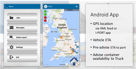
The project integrates space-based information into an intermodal freight transport system. The use of navigational systems enable improved the visibility of the truck fleet. AIS data facilitates improved visibility of the vessel fleet. Merging these data sources together leads to improved synchronisation between port actors, reduces delays and optimise throughput. It is critical for the proposed services to exploit existing technologies to integrate diverse information sources and provide a unified interface to improve visibility and standardise communication. Most importantly, the location data must be used to provide estimated time of arrival (ETA) information to the actors at the port. In I-PORT, this capability is provided by the ETA and tracking information service which is important in itself, and also because it is used by all the other services. The service must be able to capture the location data from existing tracking systems and/or mobile devices and mobile applications.
Users and their needs
The users targeted in this demonstration project are those which could benefit from optimising intermodal freight transport include e.g. ports, hauliers, shipping lines, railway operators, inland waterways, storage facilities.
Stakeholders include e.g. (local) authorities, customs, communication service providers, road and water authorities.
The users and stakeholders who have agreed to support the project include External suppliers include:
- JMD Haulage
- Hamburg Sud
- London Container Terminals
- Felixstowe (MCP)
- Peel Ports
- Southampton Port (Marine South East)
- Greycourt Transport
- Atlantic Container Line
- Mediterranean Shipping Company
- Paris (Transport Management)
NEEDS
The users have expressed the following high level needs for improving freight transport through ports:
The hauliers expressed a need to have further information of cut-off times
Hauliers need to improve the visibility of ships that have arrived early at the port
There is a need to remove the paper side of VBS bookings to improve efficiency
There is a need with vessel operators to interface with current tracking system used to avoid storms
There is a need with the clients to understand the position of inland
The port expressed a need to improve the visibility of incoming vehicles, e.g. by geofencing.
Service/ system concept
The following services have been defined:
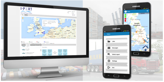
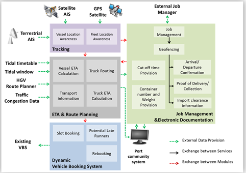
- The Tracking module retrieves the location of vessels and trucks. It uses satellite AIS data to track the vessels and also uses GPS data to track trucks. This information can then be displayed on a map to the relevant actors to help plan requisite resources and to be used by the ETA service and in due course the DVBS service ( see below).
- The ETA and Route Planning module takes into account the location of the truck, the destination of the truck and will use an HGV-optimised route planner to calculate the most suitable route. The computation also takes into account traffic information to either provide a new route or to take into account the delay for the calculating the ETA. Port terminals, hauliers and shipping lines are able to view a list of trucks - according to the systems ETA calculation
- Job Management and Electronic Documentation focusses on collecting data related to transport jobs for container import or export and providing this data to the DVBS service so that I-PORT can match the vehicles to the bookings at the ports.
- The Dynamic Vehicle Booking System module complements existing Vehicle Booking Systems (VBS) or reservations systems by enabling adjustment of vehicle slots in the port terminal. I-PORT provides a framework/component that enables currently deployed systems to be dynamic. In case there is no currently deployed system, I-PORT provides a VBS with standard functionalities offered by existing systems or a link to the port/terminal reservation or pre-announcement system if that exists.
Space Added Value
The Project integrates space-based information into an intermodal freight transport system. Using navigational systems improves the visibility of the truck fleet. AIS data is being used to improve the vessel fleet visibility. Existing services focus on these two elements but do not integrate the data at the port (road/ocean) interface. Merging these data sources will lead to improved synchronisation between port actors, reduce delays and optimise throughput. It is critical for the proposed services to exploit existing technologies to integrate diverse information sources and provide a unified interface to improve visibility and standardise communication. Most importantly, location data is used to provide estimated time of arrival (ETA) information to the actors at the port. In I-PORT, this capability is provided by the ETA and tracking information service which is important in itself, and also because it is used by all the other services. The service must be able to capture the location data from existing tracking systems and/or mobile devices and mobile applications.
Current Status
The project has achieved successful completion of Factory Acceptance Testing and the team is agreeing test scenarios with the representative end user community for Site Acceptance Testing.
Prime Contractor(s)
Subcontractor(s)