Objectives of the service
Bathymetry is the measurement of depth of water in oceans, seas or lakes. The Bathymetrics Data Portal service is focused on the coastal marine environment for the global market.
A web-based service has been created to provide immediate, off-the-shelf, online access to bathymetry derived from very high resolution satellite imagery. In order to meet production needs at a truly global scale an efficient production environment has been established with focus on efficient work flows and reduction of operator involvement.
There is currently a lack of shallow water bathymetric data around the world due to the high costs, lead-time, and health and safety issues involved in collecting this data using the more traditional data collection methods of Multi Beam Echo Sounder (MBES) from boats or Light Detection and Ranging (LiDAR) from aircraft. This satellite derived data service is of great interest to users globally across a number of sectors for use in activities such as feasibility and design of marine and coastal infrastructure, charting, construction and environmental impact studies.
Users and their needs
The users are all active on a global scale and cover a large range of the potential market segments for Satellite Derived Bathymetry (SDB). The market sectors covered are 1) Large Infrastructure Construction, 2) Marine Science and Technology Consultancy, 3) Seismic Surveying Company, and 4) a leading online Marine Data Provider. Alongside our Involved users, sales have also been made into the Oil & Gas, Government, Environmental and Navigation sectors.
Common for all the users are their interest in SDB since it offers a faster and more cost effective solution compared to traditional bathymetry collection.
Our four involved users have varying needs and operational scenarios. These are summarised, by user, as follows:
User 1, Worldwide
- Port design – SDB reduced the high costs associated with survey information for designing existing and new ports.
- Tsunami modelling – SBD will provide much more detailed data about shallow water areas and help increase the accuracy and performance of modelling run up.
User 2, UK Overseas Territories and Caribbean
- There is a lack of both recent and sufficiently high quality data. This data is critical to understanding the characteristics of the local marine environment and developing long-term sustainable coastal management plans.
User 3, Arabian Gulf and Red Sea
- Coastal seismic survey – vessels must operate in waters with little or no available bathymetric data. Detailed and recent SDB data will allow vessels to safely work in these areas.
User 4, Worldwide
- With SDB data it will become possible to provide comprehensive coastal bathymetry data to end users to supplement the currently available low resolution bathymetry layers.
Service/ system concept
The service has validated the business case for provision of an off-the-shelf satellite derived bathymetry service. By engaging directly with customers and involved users throughout the Demonstration Project, the suitability of the proposed service has been demonstrated.
The service focuses on the following key elements:
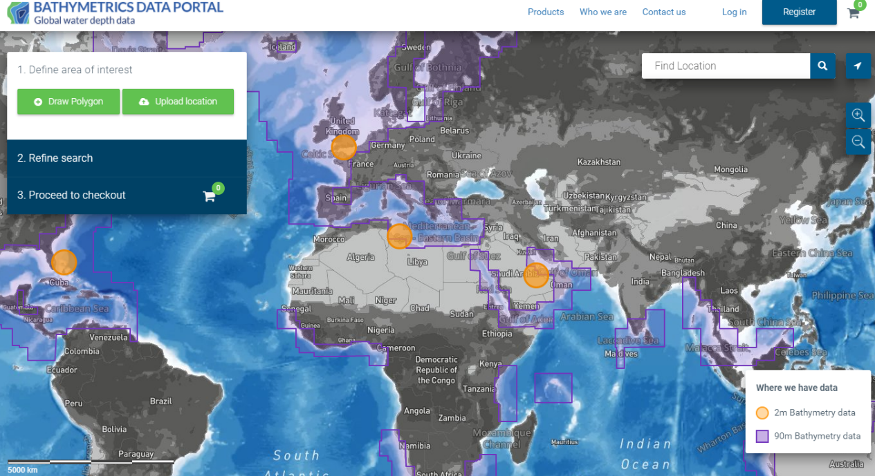
- Immediate access to a Satellite Derived Bathymetry dataset via a web based portal (http://bathymetrics.shop);
- Ensuring that customers always have instant access to an up to date dataset. The service has a staggered maintenance and update approach, with dynamic and changing shallow water regions being updated every 2 years and static regions being updated at least every 5 years;
- Access to additional value-added services such as requesting and delivery of bespoke SDB dataset generation via the Bathymetrics Data Portal;
- Access to additional value-added services and datasets in the future. This is outside the scope of this Demonstration Project.
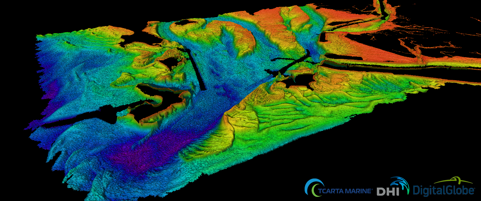
Through an agreement with DigitalGlobe, the service utilises access to WorldView-2 and WorldView-3 imagery to create depth values for every 2 metres, to water depths of 20 metres, where conditions allow.
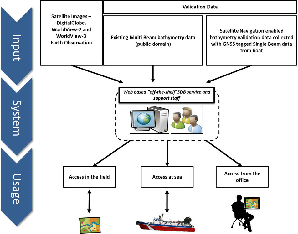
An overview of the system is shown in the image below.
Space Added Value
The development and delivery of our web-based, off-the-shelf, Satellite Derived Bathymetry service to our users requires the integration of 3 space assets:
- Earth Observation data – DigitalGlobe archive of WorldView-2 and WorldView-3, very high resolution imagery is being used to generate the standardized Satellite Derived Bathymetry dataset.
- Satellite Navigation – Global Navigation Satellite System (GNSS) will be utilised as echo sounding water depth data is used for the calibration and validation. Echo sounding water depth data requires the use of satellite navigation for its collection;
- Satellite Communication – The service is accessible while out at sea. Through the use of satellite communication via on-board vessel systems data can be downloaded for immediate deployment.
Current Status
The demonstration project has been completed, successfully passing the testing phase, and pre-operational usage period. A web portal is now available for searching and instant purchasing of bathymetry data: https://bathymetrics.shop
A Satellite Derived Bathymetry work flow has been developed that is efficient, and involves rigorous quality assurance and quality control procedures. All Satellite Derived Bathymetry data is provided with an indication of uncertainty, which is of great value to users.
Alongside 2m resolution Satellite Derived Bathymetry, The Bathymetrics Data Portal also provides instant access to 90m resolution bathymetry data. Customers can therefore access data, even in locations where satellite technology is not viable or feasible.
Prime Contractor(s)