Objectives of the service
LB is a growing health threat. Globally, the disease can be found in at least 80 countries, making it an issue of worldwide significance. If it is not diagnosed and treated promptly, LB can lead to a serious chronic, debilitating disease. LB is caused by a bacteria, Borrelia burgdorferi, which is carried by ticks. Over the last ten years the number of cases reported in Scotland has increased more than ten-fold. Currently there is little accurate information available about the epidemiology of the disease and locations of “hot spots” of transmission, making it difficult for people to know how to reduce their risk of infection.
LymeMAP is a LB identification, mapping and risk management system that includes risk maps, advice and information, incorporated within a smartphone app and web portal. This health information and management tool responds to the needs of health care professionals, outdoor workers, resident populations and tourists by providing stakeholders with a better understanding of the factors affecting tick distribution and LB risk, as well as providing information about appropriate action to take when bitten by a tick.
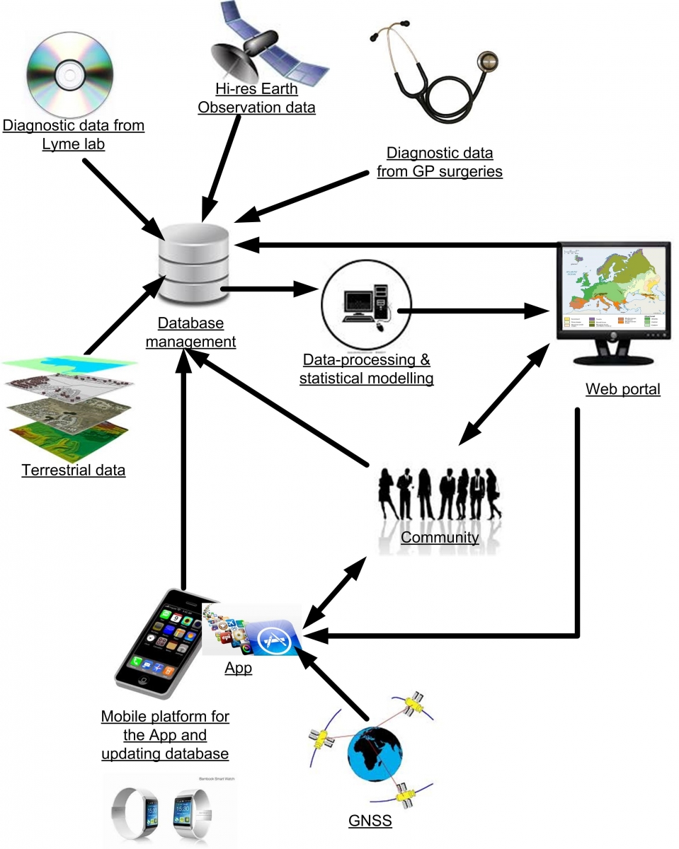
LymeMAP combines data (including EO satellite data, GPS data, Lyme data from Scottish National Lyme Borreliosis Testing Lab, data from General Practitioners, and from end-users) using spatial modelling techniques to produce maps of Lyme risk and vector distributions. Users are also able to report locations of ticks and bites to the central database.
Users and their needs
Health care organisations (Health Protection Scotland and Health Boards), Health care professionals (General Practitioners and other clinicians), and resident and visiting populations (individuals, families, leisure activity groups and outdoor workers) represent the main end users of the service. User needs can be summarised as:
- specifically targeted information about tick avoidance and management for specific occupational health groups and for NHS patient communities;
- reliable predictions of tick distribution and areas of high Lyme disease incidence. These enable identification of infection risk ‘hot spots’, allowing better advice on tick bite prevention, and increased awareness of what to do if individuals are bitten and or show signs of infection.
- a system that enables the Highland population and visitors to view the changing risks during the year;
- a system that allows Users to report the locations of tick observations and tick bites to a central database;
- an end product which is affordable, reliable, contains accurate information and is easy to use.
Targeted Users come from the Scottish Highland population and visitors.
Service/ system concept
LymeMAP is driven by user and stakeholder requirements on one side and by technical expert knowledge on the other, using positive feedback loops from user-provided data to continually improve the information made available to the users. The system is illustrated in the Figure below.
The end service concept is based on integrating several systems with the primary objective of supplying spatially explicit LB-related data to the users with the aim of reducing the disease risk and the resulting financial burden on the health budgets. These systems include:
- a secure central database to house all relevant information including: laboratory and GP disease databases, terrestrial and EO spatial data archives, risk management advice;
- spatially explicit modelling tools using these data to produce information to contribute to a ‘rapidly updated’ LB risk management system;
- Smartphone and web-based dissemination and reporting tools to both provide risk maps to the users, and allow them to report disease related events (such as a tick bite) to the central database, to allow refinement of the risk maps;
- mechanisms to allow user feedback to direct further product development.

Space Added Value
The 2 principal assets that the system will utilise are Earth Observation (EO) and Global Navigation Satellite Systems (GNSS):
- EO data will provide the suite of covariates that is necessary to produce spatial distribution models of disease and vector risk. These covariates are either direct measures provided by the remotely sensed imagery such as altitude or vegetation cover or more distant derivatives such as land use, seasonality or bioclimatic indicators. The source of the imagery is primarily MODIS on the TERRA and AQUA platforms, but may also include Proba-V and Sentinel products that become available during the project lifetime.
- The use of GNSS through mobile platforms and dedicated apps is critical (i) to provide location-specific information on LB risk via the app; (ii) to develop more accurate risk maps through use of geolocated data submitted via the app on factors such as tick presence; and (iii) to allow the users to query the outputs for risk values at their location.
Current Status
Lyme Disease in the Highlands of Scotland has not only become a major medical problem but also has major consequences for the Highland economy, particularly its impact on the tourism and businesses involved in the outdoors. LymeMAP is the proposed solution.
The LymeMAP feasibility study is now complete and the Final Review meeting was held on 12th May 2016. The conclusions are:
- There is a clear need for both an App and Web Portal providing quality assured information
- Potential customers within several user groups could be identified
- The proposed solution is technically feasible
The project has received substantial attention from the media and has already had a significant impact on both professional and public perceptions of Lyme Disease in Scotland.
A roadmap has been developed to implement the proposed services. The consortium is currently preparing the outline proposal for a follow-on demonstration project within the ESA IAP programme
Prime Contractor(s)
Subcontractor(s)


