Objectives of the service
Keeping roads systems in good condition is fundamental for the safety and comfort of road’s users. In many cities, in fact, several roads suffer from the presence of deteriorations of different nature (cracks, potholes, voids and deformations of various types) depending on various causes, such as water infiltration, stress from heavy loads and weather-climatic effects.
The timely detection of cracks and potholes, especially the critical ones, their recording and notification on a dedicated system, are important to prevent the evolution into more serious defects, to enable an adequate maintenance mechanism aimed at guaranteeing the quality of the transport system and, above all, at the safety of drivers.
It is starting from this scenario, typical of big cities as Rome is, that MALIBU solutions rise.
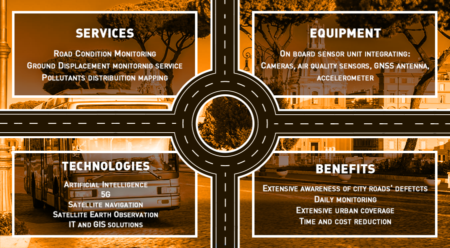
The MALIBU system, however, goes beyond the mapping of roads’ asphalt conditions; hereafter, the main services are presented:
-
Mapping and monitoring the status of integrity of the roads' asphalt. This is possible through a sensor unit installed directly on board a bus during the demonstration phase which, thanks to repeated daily passages on the same route, and thanks to the use of Artificial Intelligence technology and the 5G network, guarantee awareness always in line with the actual state of health of roads' pavement (Service 1).
-
Mapping the roads of the city area via SAR satellite data (Service 2).
-
Qualitative mapping of the air quality along the streets traveled by public transport equipped with sensors (Service 3).
Two more services, thanks to the types of sensors installed on bus, are derived; these are listed hereafter.
Sub-service 1 is a service dedicated to the analysis of the passengers’ flow (at each bus stop) of importance for collateral purposes that can be explored by the user (e.g., for marketing purposes, for the upgrading/remodulation of bus stops).
Sub-service 2 is based on vibrations’ information provided to technicians, which may have impacts on the structural integrity of the vehicle in the long term.
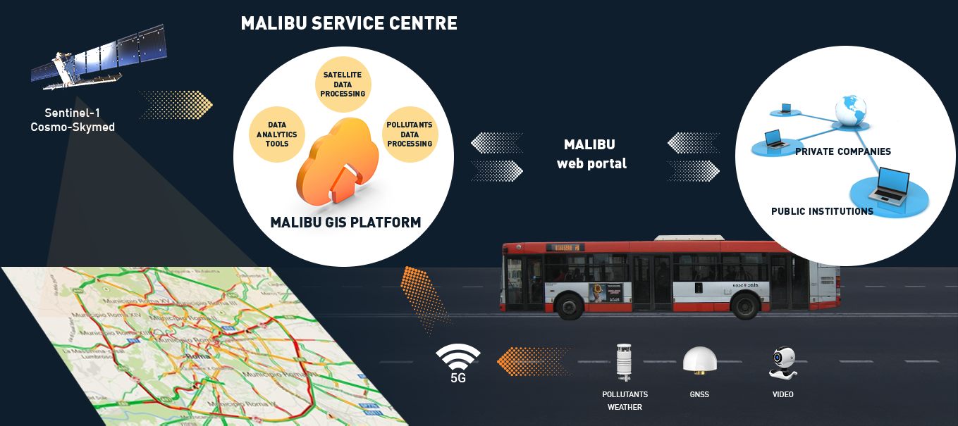
All the services listed above are distributed via a web platform, equipped with i) a content management section, where reports, graphs etc. are stored and visualised, and ii) a GIS section where geospatial information are presented.
Users and their needs
MALIBU is intended to provide services both to the private sector made of companies responsible for the surveillance and monitoring services, generally entrusted by Municipalities through tenders, and to Municipalities.
Users involved in the project are represented by i) AVR Group, a private company responsible, among other activities, for the service of road surveillance and monitoring, and ii) ATAC, the public company dealership for a large part of the local public transport service and the management of supplementary services in the Rome city area. Both are interested on different services and sub-services that MALIBU can provide.
The most cogent needs expressed by the user responsible for surveillance and monitoring activities are, summarizing:
-
Awareness about the status of asphalt roads degradation.
-
Defects’ detection, with a special focus on potholes and cracks.
-
Severity of the detected defects and timely alerts.
-
Defects’ evolution for prompt interventions.
Moreover, the typology of sensors installed on board the ATAC bus, travelling daily across the urban roads, also allows to satisfy secondary types of needs, such as:
-
The extent of vehicle stress due to vibrations the bus is subjected to (caused by the main defects of the roads).
-
Passengers’ flow analysis at the bus stops for logistic interventions and marketing purposes.
-
Qualitative mapping of the distribution of air pollutants along bus routes and bus stops.
-
Qualitative evaluation of the roads’ conditions status.
Besides these services, derived by the on-board sensor unit, MALIBU also offers:
-
Ground displacement service for the mapping and monitoring of slow movements and sinkholes potentially affecting road infrastructure elements.
Results collected during the demonstration phase are distributed via web platform where reports, graphs and geospatial layers can be collected and provided to end users coherently with their possibly diverse workflows.
MALIBU services, in the frame of project execution, were offered to Italian users.
Service/ system concept
MALIBU main service offers to the market of reference a simple, scalable and replicable solution for the detection and mapping of asphalt’s defects mainly in the urban road network, through the use of i) public transportation vehicles that can guarantee an extensive road coverage (as demonstrated during the pilot phase), ii) inspection vehicles of private companies which, making use of public vehicles already operating on the roads, could benefit of the automation of some of the activities.
The equipment, software tools and approaches used are:
-
Sensors installed on board vehicles: high-resolution COTS video cameras, accelerometers and weather/air quality sensors for analysing possible correlation between road anomalies and meteorological conditions.
-
Multi-constellation GNSS receivers for vehicle tracking and geo-referencing of acquired data.
-
non-invasive analysis software tools of the road surface based on cutting-edge Computer Vision techniques (Deep Learning), to automate the process of detecting anomalies.
-
Descriptive and proactive data analysis tools, to provide index with which determine the current road surface condition.
-
Interferometric analysis ttools of SAR images for the mapping and monitoring of slow ground movements.
-
5G communication technologies, necessary to guarantee the throughput and latency necessary to support the flow of data acquired by the sensors installed on board the vehicles towards the processing center and to allow the timely identification of damages requiring prompt interventions.
The picture below shows the operation approach of the MALIBU system.
Space Added Value
The space assets used in MALIBU are Earth observation (SAR) and Navigation.
The EO space asset is at the base of the delivery of one of the three MALIBU services. Information derived by SAR data are used both as a preliminary base of knowledge in terms of awareness on the zones mainly exposed to subsidence and sinkholes phenomena, and to understand if potentially affecting roads’ integrity.
The SAT-NAV space asset, with a special focus on GPS (US) and Galileo (EU) GNSS constellation, provides its added value for the georeferencing and timely fixing of the information acquired by the on-board sensors’ units. In details for:
-
Positioning in a reference system of deteriorations/anomalies.
-
Time correlation between dataset acquired by different sensor units, e.g., accelerometers, camera, and meteorological sensor units.
-
Visualization of processed sensor data on a web GIS platform.
Current Status
MALIBU pilot phase closed after a demonstration period of around four months, started on the 15th of October 2024 and ended at the end of February 2025.
Objectives declared at the beginning of the project were reached: three main services were delivered to end users, plus two subservices and one qualitative index.
Regarding the MALIBU core service, during the demonstrator phase, more than 5.000.000 images have been acquired and processed during bus daily transportation exercise for a total of almost 26500 road defects detected along more than 500 km of bus routes and more than 1700 alerts were delivered to users in near-real time when critical defects were detected, provided both via e-mail and on the web platform.
The system "in motion" on-board the public bus was able to collect data spread on the territory, aggregate them and deliver information and services of different nature to end users.
Prime Contractor(s)
Subcontractor(s)