
Objectives of the service
The proposed “mAPP’ing” activity is a framework for the prototyping of a couple of new-generation Earth Observation products serving directly or indirectly the preservation of marine resources and coastal biodiversity.
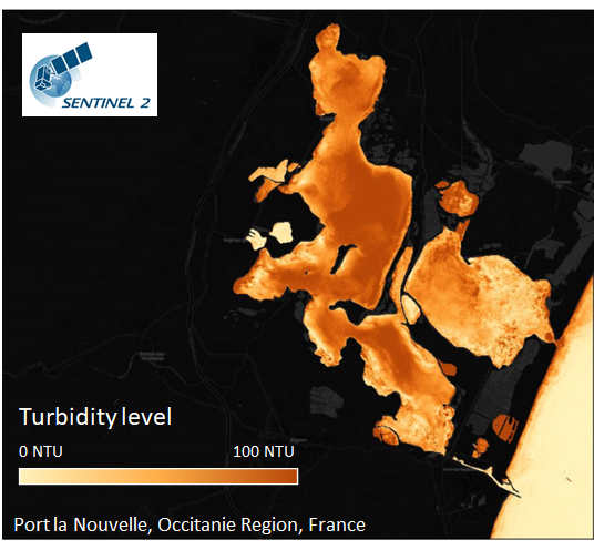
The first topic addressed is destinated to the maritime engineering market (harbour) with a tailored space-based solution designed to support environmental monitoring and mitigate impacts of their dredging activities over coastal water quality. The service is built to provide active support for near-real-time turbidity monitoring during potentially impacting activities that may be responsible for a significant overload in suspended sediments in the water column, affecting water transparency and therefore adjacent marine ecosystems (e.g. coral reefs, seagrass) and aquaculture. Environmental policies are strict with regards to turbidity. Whilst current monitoring and alert systems are based on networks of in-situ turbidity sensors providing accurate real-time information, spatial coverage is lacking. EO based products directly plugged and feeding marine data platforms are a desired evolution of such systems, enhancing spatial assessment of coastal processes affecting turbidity background and real impacts. This would be a new system serving every-day environmental management, before, during and after the end of working operations.

The second topic is related to the monitoring of sargassum events affecting the Caribbean/ Gulf of Mexico area which are responsible of massive landings over the beaches and thus having serious impacts on biodiversity, population health, beach attractivity and at the end, tourism. Recently, regional authorities have raised interest towards a regional monitoring service based on satellite data, coupled to forecasting capabilities supporting a better acknowledgement of sargassum dynamics and anticipation of sargassum landings. This already-existing product is expected to be turned to serve the insurance sector and provides valuable data for the definition of sargassum vulnerability in this part of the world.

Users and their needs
NEAR REAL TIME TURBIDITY MONITORING FOR MARINE ECOSYSTEMS CONSERVATION
 | The proposed case study is the dredging operation at Port-la-Nouvelle, south of France, started in autumn 2019 that will lead to massive extension of harbour infrastructures by 2022. The managing authority is the Occitania Region, who has previously experimented satellite-based services for early assessment of regional turbidity conditions and is now engaged as the main final end user in the project. |
Our service targets to provide independent expert technical assistance to environmental managers from sectors as varied as:
- Harbour industries
- Marine Renewable Energy industries (offshore wind farms)
- Dredging / Coastal Engineering
- Governmental authorities
SARGASSUM BEACHING MONITORING
 | Descartes Underwriting (DU) is an insurance broker specialized in new data solutions (Insur Tech). i-Sea and DU are preparing a new service offer dedicated to insure coastal tourism professionals against financial consequences of major sargassum events. Earth Observation is used as entry data to evaluate sargassum coastal vulnerability and intensity of the sargassum phenomenon affecting every part of the Caribbean/ Gulf of Mexico shores. DU has selected Cancun, Mexico has the pilot test area, where tens of coastal resorts have recently been affected by massive sargassum beachings.
|
Service/ system concept
NEAR REAL TIME TURBIDITY MONITORING
i-Sea developed a turbidity monitoring service for harbours and offshore renewable energy fields, allowing industries and public entities to comply to environmental policies and enrich their work area outlook. We are pushing forward with increasing lines of services and providing Satellite Earth Observation products in support of turbidity monitoring and impact assessment for Coastal Engineering Projects.
Key activities aiming at reducing the impact of coastal engineering projects on marine ecosystems include:
- Satellite data processing to obtain water quality parameters
- Thematic interpretation of coastal sediment dynamics to ensure appropriate understanding of issues and needs. Generation of a new knowledge base through interpretation of the generated data will allow highly valued information to the end user.
We are seeking a systematic automation of the data processing phase, therefore reducing drastically human intervention and processing times.
TURBIDITY FORECAST
i-Sea developed a natural turbidity forecast service for harbours and offshore renewable energy fields, allowing works operators to adjust or delay the schedule dredging operations upon natural turbidity forecasts. This service can forecast natural turbidity 3 days in advance every 6 hours.
SARGASSUM BEACHING MONITORING
i-Sea created a new service evaluating Sargassum beaching risks for the insurance sector. This emergent market targets professionals in the coastal tourism severely affected by massive Sargassum beaching, especially in the Caribbean and Gulf of Mexico.
i-Sea has developed the very first service enabling the evaluation of Sargassum beaching vulnerability, potentially applicable anywhere around the world.
Through the analysis of enhanced satellite imagery, threatened entities will be able to follow Sargassum raft displacements and forecast beaching risks.
Currently there is no other existing insurance coverage solution for this kind of environmental hazard. We are witnessing severe loss of activity for hotels and local economies, and added cost for cleaning beaches in coastal cities.
2 Levels of Service are available:
- Basic service: Diagnosis of position vulnerability to sargassum beachings and definition of adequate insurance premiums
- Crisis Extended Service to be activated for imminent incoming threats: Monitoring mode + alert reporting
Space Added Value
Copernicus Sentinel-2/3 datasets (MSI 10 m, OLCI 300 m) are used for these services on a daily basis to provide real observations of processes and phenomena affecting coastal water quality. Processed using state-of-the-art marine optics algorithms, and in some particular cases machine learning algorithms, satellite-derived products of coastal turbidity and sargassum abundance are then ingested into SINAY’s marine data platform designed for user experience enhancement, and where satellite products may be combined to in situ data, ground truth observations, and modelling forecasts to enhance the system predictive capabilities.
Current Status
The mAPP’ing project has started in March 2020. Since then, very active discussions along with DU have led to the design of the solution they will use short-term to support insurance premiums definition along stretches of coastline injured by massive sargassum landings. Developments and service prototyping are finished and the sargassum landing vulnerability product has been implemented in the web platform. In the meanwhile, DU is seeking for final end users along the Cancun region to be involved in the pilot and who could be early adopters of the sargassum insurance service.

Considering the harbour pilot, involvement of Port-la-Nouvelle authorities and environmental managers has concretely started in April 2020. A dual service was chosen by harbour authorities and implemented. Demonstration is still ongoing. The first product is based on near real time turbidity monitoring spatially wide (from EO data) delivery to help understanding the natural turbidity events detected and contribute to determine the responsibility for field-detected turbidity events. The second one is also based on EO data, that coupled with weather and ocean forcing, can contribute to anticipate turbidity events. The developed services are mostly based on the use of Copernicus Earth Observation infrastructures (Sentinel-2/3).
A demonstration meeting will be held at the end of September to showcase the solution products to our end-user.
Prime Contractor(s)

Subcontractor(s)
