Objectives of the service
In maritime operations in the harsh arctic environment, it is often beneficial to have fast access to good quality earth observation and met-ocean data.
The earth observation data can come from many satellite sources with different access points, formats, delivery timelines and ordering deadlines. Ordering processes are often complicated and time consuming. In addition, optimal utilization of the data, requires knowledge, skills, good communication and software tools.
When satellite imagery is used for maritime operations, weather information is an important part of the analysis. It is therefore important that the relevant imagery and met-ocean information can be accessed and analyzed in a common easy-to-use interface. The interface must also be resilient in a low-bandwidth communication scenario.
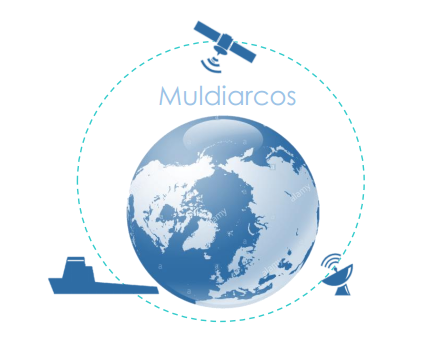
The Muldiarcos project has integrated ordering and delivery of formatted satellite imagery in a common, robust interface with relevant met-ocean data from both non-commercial and commercial sources.
Users and their needs
Two main user categories have been involved during the project, offshore oil and gas and commercial shipping represented by the cruise operators.
The offshore oil and gas industry is under quite heavy pressure both from a price but also from an environmental political perspective. Total service costs is therefore a critical issue and cost-effective solutions to obtain and serve the customers need to be established. The benefit for the offshore industry will be economically by operating more effectively, but also socio-economically by documenting use of additional services and information to allow for safer and more environmentally feasible operations. Viking Supply Ships has been the key end-user for this market segment.
The Arctic and Antarctic cruise market is growing and in addition to an increasing need for updated and reliable information for operations safety in or close to ice, this customer segment also uses the information for planning of the cruises. The delivery of the service to the cruise market has been an important activity in this project and Hurtigruten Group is defined as a key end-user for this market segment.
The input from the end-users has been essential to understand the demanding operational environment. The implemented functionality has also been strongly influenced by the end-users, and the two phases of pilot trials has been important for identifying areas of improvement during the project.
The key users for the demonstration project are both Norwegian, but they operate on a global scale.
Service/ system concept
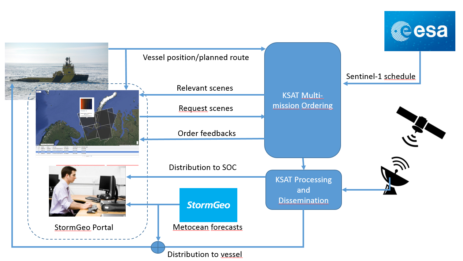
The MULDIARCOS solution has integrated existing service offerings from KSAT and StormGeo into an end-to-end service chain. The chain is based on an integrated use of navigation and Earth observation where the vessel position and planned route is the baseline for providing access to data and information.
KSAT has ordering, downlink and processing capabilities for all the commercial and free SAR satellites in orbit today. SAR satellite imagery from these sources can, in addition to be used for detection and monitoring of sea ice, be used for environmental monitoring (oil spill detection) and increased maritime domain awareness (vessel detection) on a global scale.
StormGeo has both a met-ocean web interface, Vortex, and a routing on-board solution, StormGeo On-board/BonVoyageSystem (BVS). Vortex has mostly targeted Marine activity in the Oil & Gas segment, but also recently the Offshore Renewables market. BVS has mainly been used by the shipping industry, with focus on low bandwidth adoption of data and less focus on high-resolution services, but by improving content and functionality it can also be used for vessels supporting other types of marine operations like exploration/drilling, cable & pipeline lay and cruise traffic in the Arctic.
This project has enabled a streamlined handling of multi-mission satellite sources in both the Vortex and BVS solution. By making satellite information provided by KSAT more accessible, easier to order and better displayed in relation to other arctic risk factors, the operational picture becomes more complete and it will be faster and easier to make critical operational decisions.
Space Added Value
The space assets utilized in the implemented service have mainly been earth observation data from SAR and optical satellites. The main goal has been to demonstrate a streamlined end-to-end ordering and delivery process of imagery from a variety of satellites. Although Sentinel-1a/1b have been the most important imaging sensors in the demonstrations, commercial SAR sources have also been utilised to demonstrate the complete sensor suite normally used in the targeted market.
Satellite telecommunication has been used to transfer the data to vessels in remote locations. Depending on availability at the time of demonstrations, the satellite communication solution best suited for the vessel operations was utilized for communication with the vessel. The satellite imagery was formatted according to the available communication bandwidth and related cost.
Satellite navigation was an important part of the vessel operations. The demonstrations utilized the vessel positions and planned route to evaluate and plan satellite scheduling. In addition, satellite AIS information was important to analyse vessel traffic and ice routing in the operations area, and vessel positions at the time of satellite imagery will be indicated to ease the image-to-ground referencing.
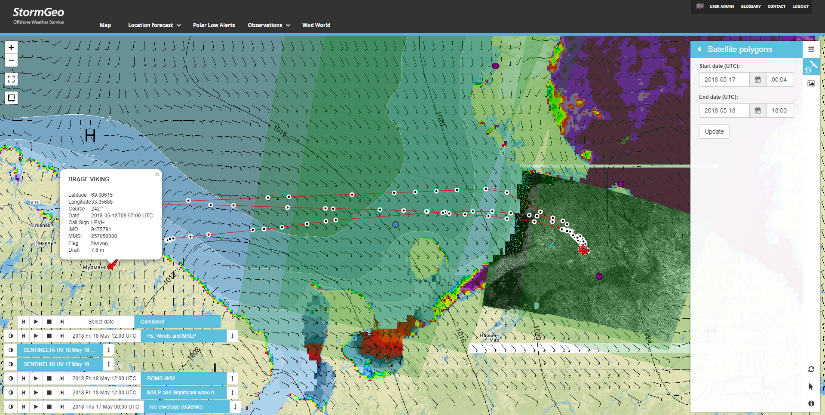
The following screenshots shows how the MULDIARCOS service was utilised during the phase 1 pilot demonstration. The vessel “Brage Viking” transported supplies between the Prirazlomnoye offshore platform in the Pechora Sea and Murmansk.
Current Status
The Final Review Meeting for the MULDIARCOS project was held in October 2019, and the project has been successfully finalised.
The service demonstrations performed during real operational scenarios have verified the increased efficiency both for the end-users and data providers. The ability to access and do analysis of weather information, satellite data and vessel traffic information in a single interface represent a significant improvement for the users.
Continued improvements to the overall service should focus on added functionality to facilitate more advanced analysis in the user interface, increased robustness of the service in scenarios with very low-bandwidth or absent lines of communication, and establishment of baseline levels of service according to the requirements of the different market segments.