

Objectives of the service

Maritime operators face numerous challenges, including the lack of an efficient alert system warning them for dangerous weather.
MWI’s Alert service aims to:
- Enhance passengers and assets safety,
- Help maritime players mitigate risks proactively,
- Save costs,
- Ensure operational continuity and security.
MWI carried out a Kickstart project that enabled it to detect dangerous weather areas at sea. This feasibility study also served to clarify users demand and thus refine our vision for MWI Alert service. MWI is currently working on hazardous zones dangerousness in order to avoid sending too many ‘false’-alerts and to successfully quantify the risk.
Users and their needs
MWI primarily targets the following market segments:
- Yachting & Superyacht
- Offshore energies
- Shipping & Cruising
- Complex maritime transports
- Commercial ports
- Maritime events & races
- Insurance companies
Most of the actors need:
- Highly accurate forecasts, both short and long term to manage their operations and anticipate future trends,
- Real time and short-term weather alerts in the areas where they have assets,
- Mitigating risk with tools that give them simple keys to understanding complex situations
We are working extensively internationally. We are developing our services with the aim of offering them to a global market.
Service/ system concept
Our MWI Alert system will be available for the customer through our Forecast and Routing web applications. When a customer subscribes to an offer that includes MWI Alert services, they will have the following information available on the MWI web platform:
The system will continuously monitor satellite images and data to provide live alerts near the coast but also offshore. Our tool automatically detects convective systems on those data, qualify their dangerousness (risk of big waves, gusts, strong wind, etc.), anticipate their evolution and correlate it with the customer position (or extrapolated position) in order to provide a personalized alert.
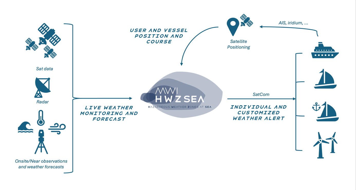
With MWI Alert service, customers will be able to make decisions that will enable them to secure passengers, assets and goods, save huge costs associated with unnecessary downtime, and reschedule operations that have been temporarily prevented.
Space Added Value
Space assets are involved at every step of the process.
- Geostationary Satellites (Meteosat second and third generation, GOES-R, GOES 18, Himawari):
They provide frequent updates on cloud development and brightness temperature, allowing for continuous monitoring of storm systems. Lightning imager onboard will provide critical real-time data for storm tracking. - Polar-Orbiting Satellites (NOAA-20/NOAA-21, Suomi NPP, Sentinel-3, Sentinel-1, SWOT):
These satellites will provide high-resolution snapshots of atmospheric conditions, including vertical profiles of temperature and humidity, which are critical for understanding storm dynamics over remote regions, particularly oceans. - SatNav provides us with AIS data and satellite position we use to locate our clients at any time.
- The weather, current and water temperature models we use are based on satellite observations.
- Finally, we use SatCom to send our forecasts and alerts to our customers.
Current Status
|
Achievements |
Work currently in progress |
Activities about to start |
||
|
Test of convective zones detection with our current customers of our MWI web applications. |
Summary of the progress made on the HWZSea project. Detailed analysis of critical issues encountered and planification of demonstration project to put this tool in production. |
Implementation of the tool in production with a demonstration project. |
||
