
Objectives of the service
Aviation weather services are usually based on numerical weather prediction models, with an updating cycle of several hours and a computational grid resolution of a few kilometres. The low resolution and high uncertainty margins of the weather forecasts imply large time margins to avoid severe weather and to ensure safe landing and take-off of aircraft at airports. This causes delays for air traffic, and significantly lower service efficiency and throughput for such airports where severe weather conditions occur frequently.
The first objective of the micro-weather service for aviation (MWS-A) is to provide high-resolution nowcasts of weather, which means forecasting of the development and trajectories of severe weather objects (e.g. convective storms and wind shears) with high spatial and time resolution from now to a few tens of minutes ahead. This helps to minimize time margins and improves service efficiency of the airport. The second objective is to monitor and predict the positions and trajectories of aircraft within the airspace and time window. The final objective is to make projections to the future and predict potential hazards by combining the weather nowcast and aircraft data, built as a service to the air traffic control, and from there to aircraft to enable safe landing and take-off, with shorter delays and loss of operability.
In the demonstration project, the MWS-A service was built for the Air Traffic Management (ATM) at the airport.

Users and their needs
MWS-A is used as a support tool for air traffic control (ATC) operations. One of the main objectives of the demonstration was to assess the efficacy of MWS-A for mitigation of the impact of severe weather to landing and departing air traffic at airports.
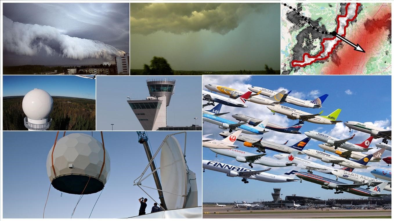
Challenges for airports due to adverse weather conditions:
-
Demand-capacity balancing between departing and arriving traffic. Adverse weather phenomena disturb the runway operability and thus the flow of air traffic.
-
Uncertainties in the estimated in-block times, and additional flight time due to delays in landing. When aircraft need to avoid dangerous weather phenomena, flying around it, changing landing runway, or joining holding pattern or any other way, it delays the landing and degrades the predictability of landing times and thus in-block times. In-block times are a vital element for efficient use of airport infrastructure and ground personnel. It has also a crucial impact to flight connectivity of air passengers.
-
Safety, especially during final approach when aircraft fly at low speed close to the ground.
Benefits of MWS-A:
-
No last-minute changes of runway assignments and estimated in-block times, leading to smoother airport operations.
-
Weather hazards during final approach are avoided - safe landings
-
Improved performance and better throughput of airport
-
Improved passenger comfort and satisfaction
The MWS market entry is planned in Baltic / Nordic part of the European geographical area. As the main demonstration site is Helsinki-Airport (ANSP and Airport Operator), the first focus for expanding the service is in the neighbouring airspace and airports, including Estonia and Sweden.
MWS-A is beneficial for all airports. Medium-size and large airports will gain significant benefit from safer and more efficient air traffic flow and capacity management. Smaller airports may also focus on safe and predictable operations for all kinds of airspace users, including U-Space.
Service/ system concept
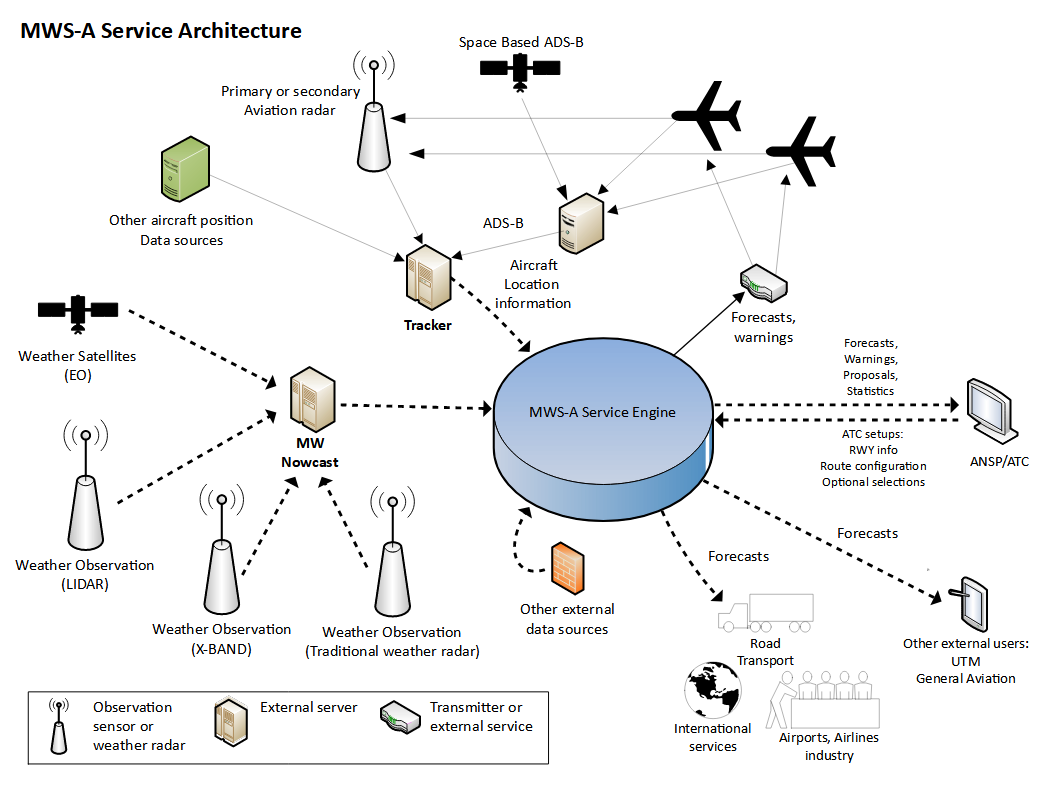
MWS-A ingests the data of C-band and X-band weather radars and also from weather lidars, whichever are in use and available at the airport. The data is processed in an optimized way to achieve the highest possible resolution to identify and make nowcasts of important weather objects. In parallel, MWS-A ingests positions and dynamical data of aircraft, applies advanced algorithms to the combined data, and generates up to 40 minutes future projections to see potential encounters between severe weather phenomena and aircraft.
Input Data
-
High-resolution weather data from available radars/lidars
-
Real-time aircraft positions (e.g. radar or ADS-B)
-
Aircraft landing and departure trajectories
Data processing
-
Trajectory prediction of aircraft and weather objects
-
Predictions of weather object and aircraft encounters
User Interface
-
Messages and alerts to ATC in standard format
-
Display showing the real time airspace situation, and chosen future prediction interpolated to the desired time instant
Space Added Value
The integrated weather forecasting-nowcasting sub-system of MWS-A exploits both space- and ground-based assets and will be built as a collaboration of Vaisala and the Finnish Meteorological Institute (FMI). At present, the FMI already provides weather forecasts that utilize data assimilation with observations of weather satellites. The weather model and forecasts obtained using the satellite data provide a large-scale picture of weather that will be integrated as a background information source for MWS-A, either through the FMI’s open data portal, or using interfaces at the Fintraffic ANS’s system. They are used for early warning of up-coming hazardous weather phenomena beyond the prediction time and spatial windows of the radar-based high resolution micro-weather nowcasts of MWS-A, and also by the ATC for optimizing the flow of approaching air-traffic already before entering the near airspace. Within the critical airspace near airports, the new radar-based nowcasts of MWS-A will be used. MWS-A performs as magnifying glass enhancing spatial and temporal resolution. It provides high resolution short-term forecasts of convective clouds and associated wind shears, and other similar phenomena that affect the flight paths of aircraft at low altitudes.
Current Status

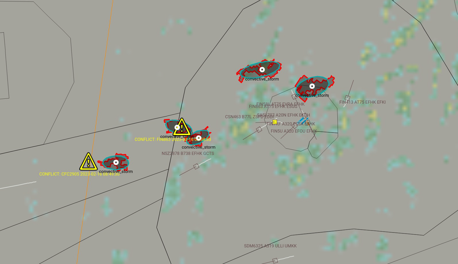
The MWS-A demonstration project started in November 2020. The pilot trials of MWS-A were conducted at Helsinki-Vantaa airport in the spring of 2023 and the final review of the project was held successfully in September 2023. As a conclusion, the service was found relevant as well as useful by the stakeholders involved (Fintraffic ANS, Isaware, Vaisala, and the Finnish Meteorological Institute). The Air Traffic Control of the Helsinki-Vantaa airport is very keen on using MWS-A in the future, and the board of directors of Fintraffic ANS have made a decision to take MWS-A in further test use at Helsinki and Tampere-Pirkkala Airports. After the test period in Finland, the ANSP organisations in the western and southern neighbour countries will be approached as the first step of international market entry.


