
Objectives of the service
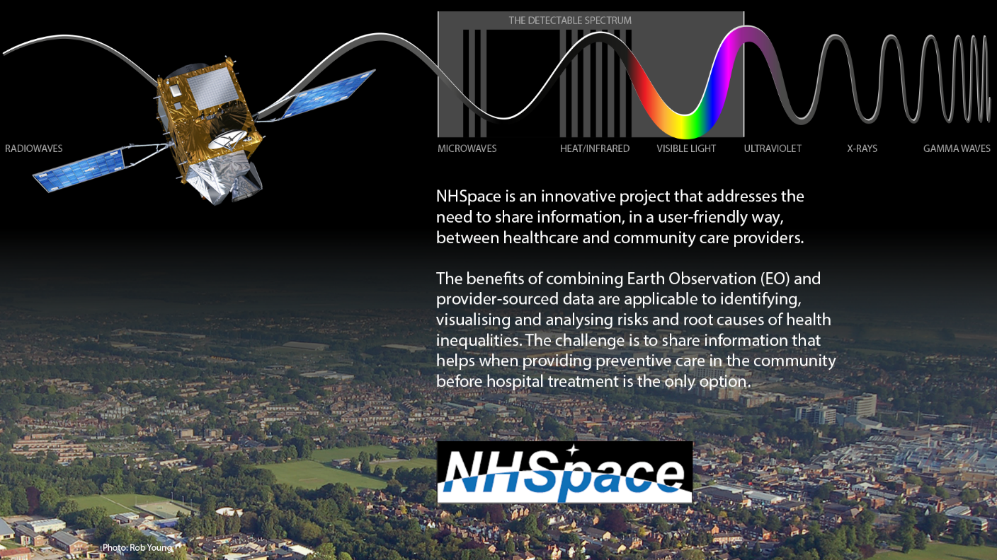
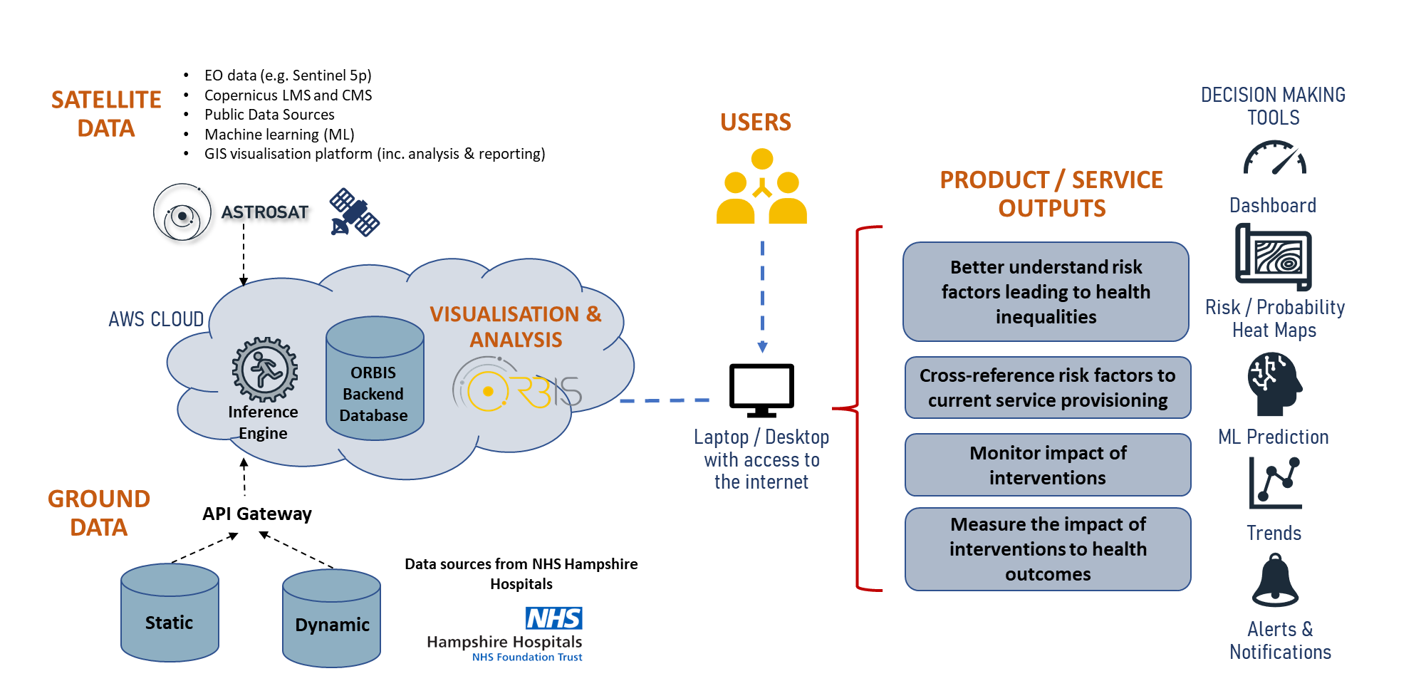
Health inequalities cost the NHS €5.6 billion per year. To reduce this bill, it is paramount that health authorities better understand how population demographics evolve over time, and the risk factors leading to significant health inequalities. It is not enough to lengthen life, the challenge is in lengthening healthy life, and population health strategies are at the core of that. To help solve these challenges, Astrosat are offering an online application allowing users to analyse and visualise a range of geospatial data targeting health inequalities by combining a variety of ground and space datasets with advanced analytics. This allows users to gain insights on population demographics and better understand correlations to the risk factors causing health inequalities at a community level. The visualisation tool enables primary care services, acute hospital trusts and Integrated Care Systems (ICSs) to:
-
Better understand the risk factors leading to health inequalities at a local level.
-
Cross-reference risk factors with service provisioning to enable a more tailored and fit-for-purpose service based on the needs of the community.
-
Monitor and understand the implications of intervention measures to aid decision making.
Users and their needs
The solution is aimed at Acute Hospital Trusts and Primary Care settings in the UK National Health Service, and is being developed with Hampshire Hospitals Foundation Trust as a key stakeholder and active project participant. The pains and gains identified by stakeholders include:
Pains
-
Patients’ health needs not being successfully captured
-
Health Service commissioners lack clarity about health-inequality root causes
-
Service provision is reactive, not preventative
-
NHS over-stretched with demands that could be shared with ICS partners
-
Data is plentiful but limited in scope, and not easily accessible or user-friendly
Gains
-
Shift focus from reactive to root-cause and move towards funding preventative care
-
Enable appropriate interventions and monitoring the impact over time
-
Assess whether it is more appropriate for another public body to take ownership of a particular inequality or risk factor e.g., presenting evidence of transport poverty issues to local or central government
-
Evaluate the effects of intervention measures by service commissioners
-
Tailor the provision and delivery of services that best meets local needs; for example, through the relocation of services or delivering them differently.
-
Encourage and empower communities to better understand how they can help themselves, taking ownership of their own health with appropriate precautions and interventions.
Service/ system concept
NHSpace brings together data from a wide range of sources to provide as much information as possible on the drivers of health inequality. This involves firstly, adapting and enhancing existing data products to target these drivers, and secondly, the development of new data products that combine space and ground-sourced data to help fill in some of the gaps in available data sources. In particular, space data is valuable for targeting drivers of health inequality in the following categories:
-
Transport, access, and isolation
-
Housing quality and fuel poverty
-
Living environment, including air pollution and green space access
-
Weather and climate related risks
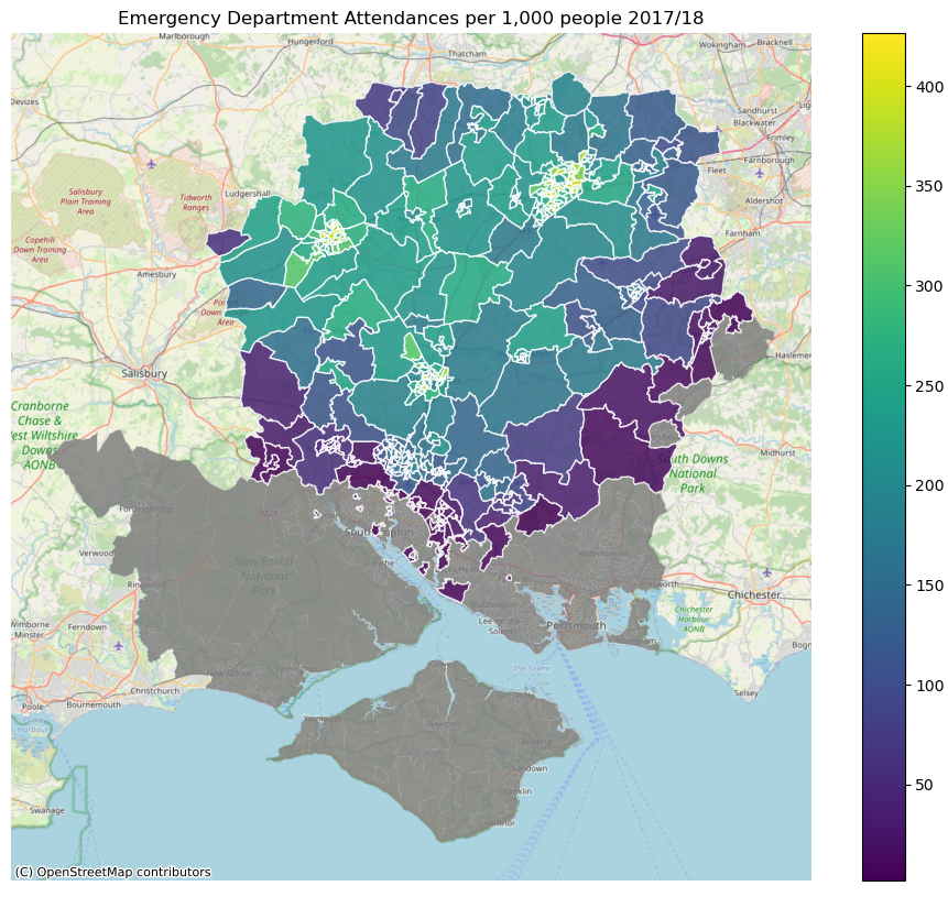
Space assets provide vital data sources for many of the algorithms used to assess and monitor the root causes of health inequalities. Prior experience with data surrounding population health, deprivation and poverty has shown that the complex web of causes and effects requires a broad range of metrics from diverse sources. In both ThermCERT and Isolation Plus, Astrosat successfully demonstrated the use of satellite-derived data to target areas in which people are more likely to experience specific aspects of vulnerability or deprivation, such as fuel poverty, transport poverty and isolation.
Space Added Value
NHSpace uses Earth Observation (EO) satellite data from the following sources:
-
EO derived land use maps from the Copernicus Land Monitoring Service identify green space, residential, commercial, and industrial districts within a local area.
-
Air pollution data from Sentinel-5P provides monitoring of pollutants known to be hazardous to health (such as SO2 and NO2) and can be combined with ground-based data on other hazardous pollutants (such as PM10)
-
Satellite-derived digital elevation models from ESA (TerraSAR-X, TanDEM-X) or NASA (SRTM, ASTER) are used in combination with land use maps and additional ground-based datasets to develop indicators of terrain-related challenges to transport and exercise facing those with restricted mobility.
-
Optical and thermal multi-spectral imaging from Landsat is used in our fuel poverty models, and also as an indicator of building age.
-
Satellite-derived weather observations from the Copernicus Climate Data Service are used for development of localised risk indicators for exposure to hot and cold weather
Current Status
User-Engagement / Requirements Gathering
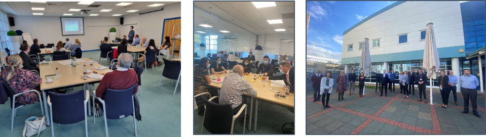
30+ contacts made (12+ organisations: NHS, local government, third sector), using one-to-one interviews, and sessions on data and security/governance. Workshop held at Basingstoke and North Hampshire Hospital 25 October 2022. Regular meetings with HHFT and wider stakeholders
Space data products
Five innovative health-related space-data products investigated. Data products are developed using Sentinel-3 and Sentinel-5p data from Copernicus Hub (SciHub), and Landsat data from NASA Worldview. The data products also make use of landcover data from Copernicus Land Monitoring Service based on data from the Sentinel-1 and Sentinel-2 missions, as well as environmental ground-based data.
Technology
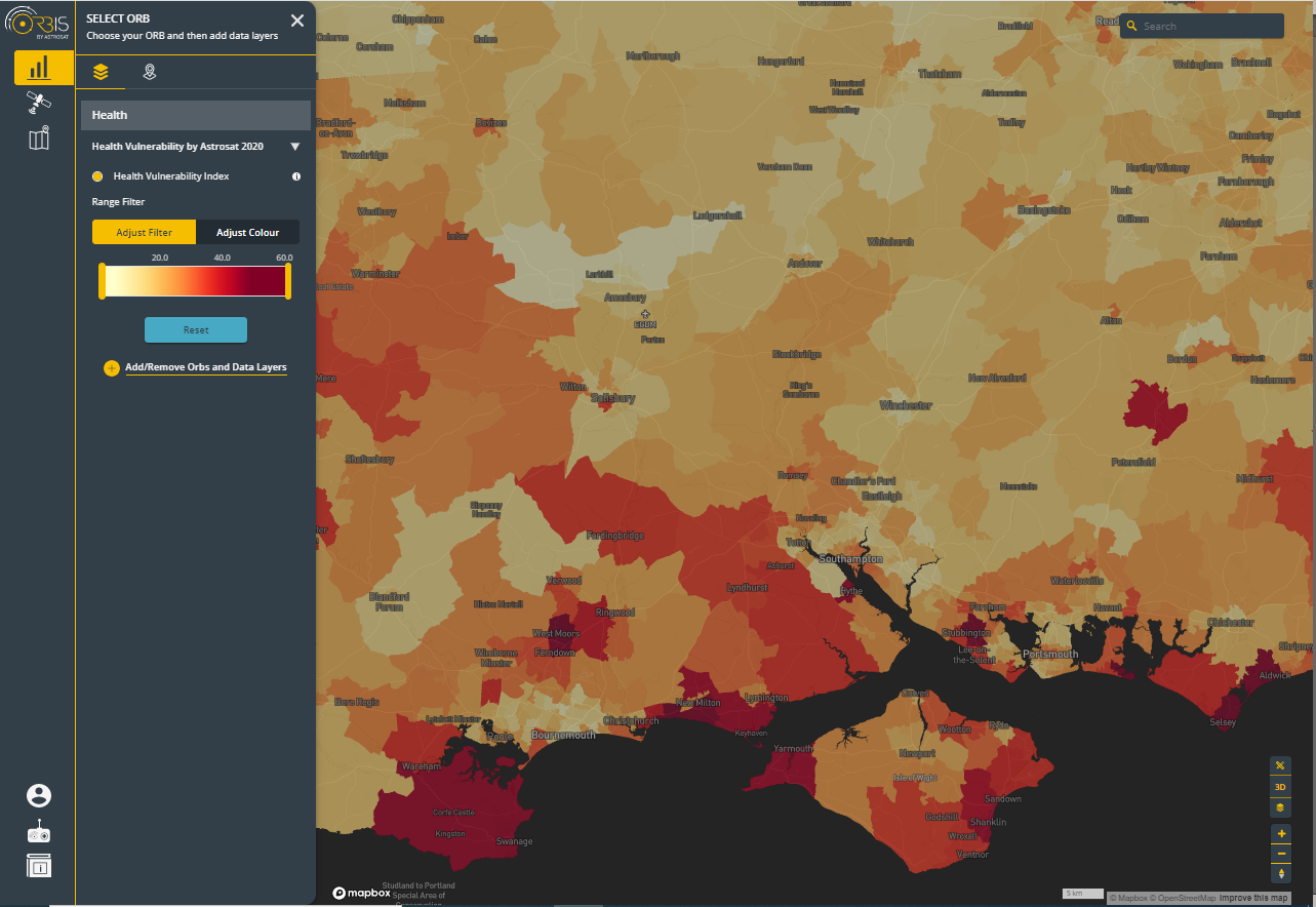
NHSpace core technology platform demonstrated to stakeholders (to support user-requirements elicitation), and concepts for new data-analysis tools.
Health-specific data sources accessed
Hospital data has been provided for analysis by HHFT and visualised in the NHSpace core platform.
Project development
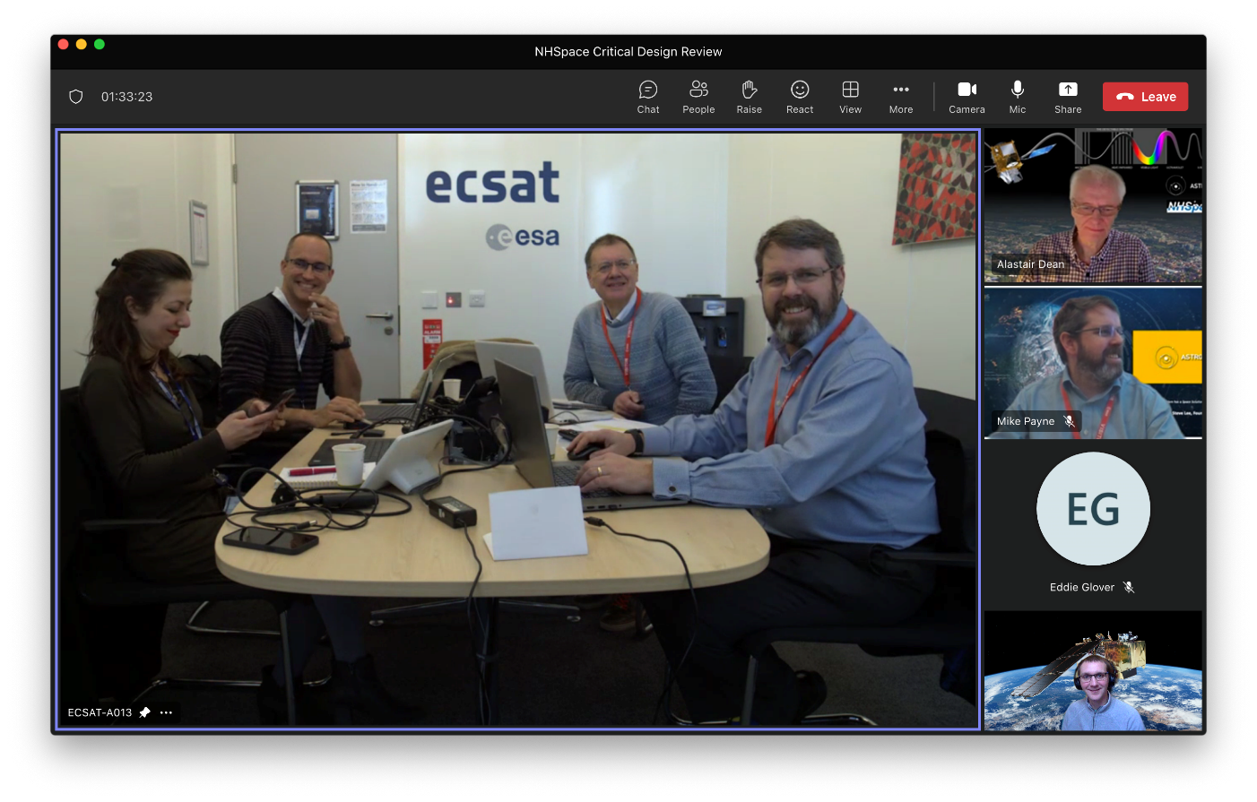
The Critical Design Review (CDR) was successfully held at ESA ECSAT Harwell on 7 February 2023, during which Astrosat demonstrated the products of stakeholder engagement and requirements gathering. Astrosat also demonstrated a prototype NHSpace platform with newly developed space-derived data-products (designed to fill gaps in knowledge about environmental precursor risk factors of ill-health and health inequalities), and new data-analysis tools. The Final Review meeting took place on 14 February 20213 and marked the end of the project Phase 1. The proposal for a project phase 2 will be worked out in the following weeks in order to prepare for the full development of the NHSpace solution, followed by some trials.
Prime Contractor(s)