

Objectives of the service
The objective of this project is to demonstrate the commercial and technical feasibility of providing archives of high-resolution satellite imagery, augmented by property datasets, to real estate lawyers, title insurers, and property surveyors.
Many questions in real estate law have a historic dimension (e.g. rights acquired through prescription and adverse possession, lawful use and development etc). Currently, there is no readily available or realistic way for a real estate lawyer to “look back in time” and make enquiries of a historical nature. Currently, a real estate lawyer might look to solve the problem via a lengthy investigative process involving statutory declarations or manually acquiring aerial photography. Separately, other segments of the property industry, e.g. title insurance, have to understand a similar number of questions to the real estate lawyer.
This project is therefore demonstrating the ability for users to be more informed at the outset of a property transaction and, crucially, be able to use satellite imagery to “look back in time” to understand legal issues affecting the use and development of property. Additional datasets (e.g. highways) and advanced techniques (e.g. Optical Character Recognition to extract key dates from old legal documents) will augment the service offering.
Users and their needs
Initially, target market users are commercial real estate lawyers, title insurance underwriters, property developers and surveyors. Expansion opportunities exist throughout the wider real estate industry.
These users value both the immediacy and reliability of information in a real estate transaction. Therefore, several problems experienced by a real estate lawyer, a title insurer, or a surveyor can be solved by providing:
- Archives of high-resolution satellite imagery, reliably time stamped;
- Contextual information sourced from HM Land Registry and local authorities;
- An intuitive platform and user-interface that can allow for reports to be created and instantly shared.
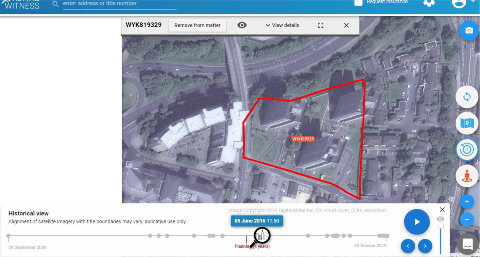
Example of archives of historic satellite imagery being displayed alongside property boundaries
Service/ system concept
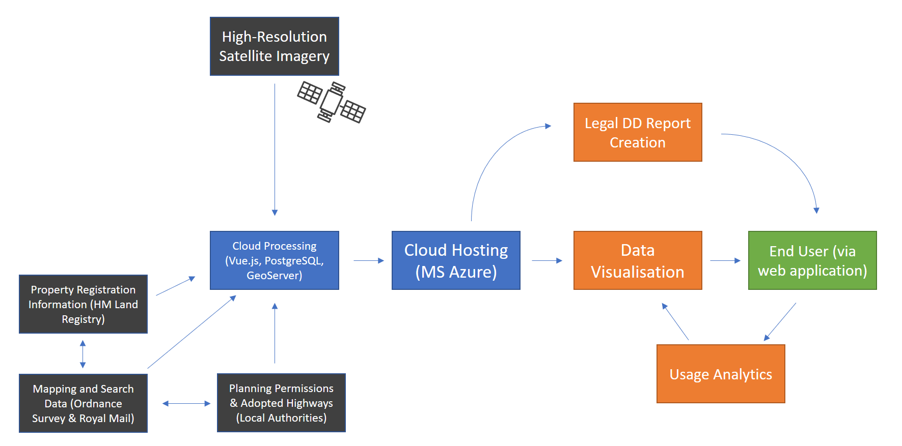
The service constitutes a web-based application combining archives of high-resolution satellite imagery, information from HM Land Registry and Ordnance Survey, and data held by Local Authorities visualised into a user-friendly interface (as shown in high-level system architecture diagram below).
The service is designed to allow a user to be capable of switching between these data sources and downloading, storing, and sharing documents and imagery that they rely upon whilst conducting their work in Orbital Witness.
Project activities also cover the development of collaboration tools to allow multiple users to work with the same information, and report generation features to create notes and outputs with the satellite imagery as a base layer.
The final service will also include user behaviour tracking and usage analytics features to increase the iterative product intelligence and progress towards product market fit that can be gained during the demonstration phase of commercialisation.
In addition, machine learning techniques in the form of OCR can extract key dates and times from old legal document scans, or AI techniques to spot legal risk.
Space Added Value
Orbital Witness is using archives of high-resolution (sub-1m) optical satellite imagery. This provides enough clarity for real estate professionals to be able to spot important detail such as, e.g. a change of use at a site, a structural change to a property, or a boundary movement.
The historical dimension within the archives of satellite operators will become a reliable legal indication of the state or use of a property at a given point in time. The space added value of this satellite imagery provides the first standardised view for real estate professionals to visualise historic development of a site.
Meanwhile, the archives of satellite imagery provide an instant manner to look at the history of a site and avoid lengthy investigative legal enquiries.
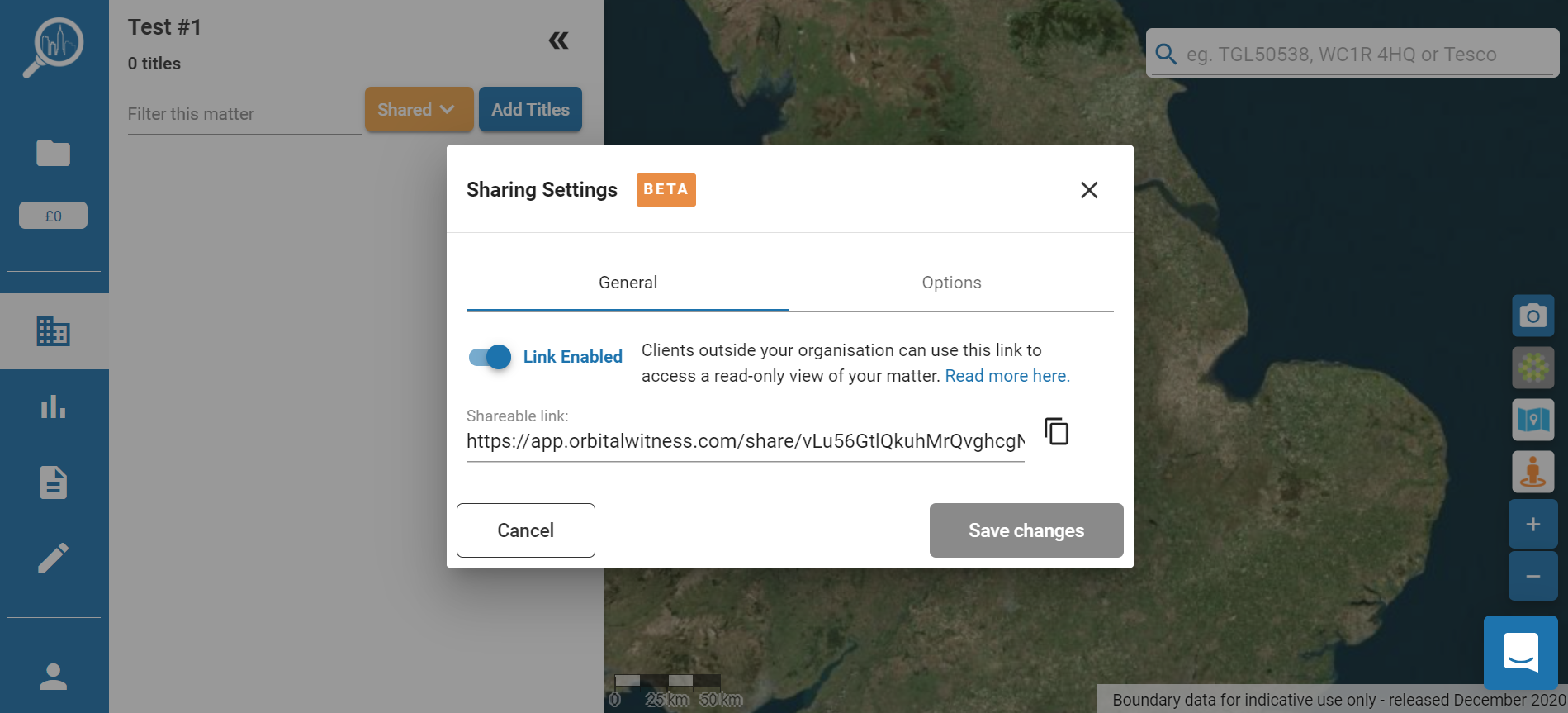
Product snapshot demonstrating ability to share content via a generated URL, with backdrop of satellite imagery.
Current Status
The project has successfully concluded, and the pilot demonstration activities validated the integration of satellite imagery archives and complementary datasets to production-ready real estate intelligence platform. Orbital Witness is already a commercial project with the first customers adopting the platform even before the end of the project in several different real estate verticals (primarily in the two main project focus areas of real estate lawyers and title insurers).
The completion of the CCN enhanced the offering of the Orbital Witness product to real estate lawyers, whilst also exploring the potential for commercial exploitation amongst insurers and surveyors.
Prime Contractor(s)
