Objectives of the service
Water managers all over the world are confronted with huge challenges related to climate change. Floods and drought hazards resulting from increasingly severe weather conditions cause worldwide economic damage, loss of nature, increased political and societal tensions, despair and ultimately the loss of lives. The lack of proper information on water availability has long been one of the most challenging obstacles in water management. HydroLogic developed, with ESA support, the successful and actively used OWASIS Soil Water Service (SWS). This service focuses on providing access to real-time water availability information. SWS has proven to be of added value to the water managers.
The frequent use of the SWS resulted in the need to better understand the actual water demand. Water managers are experiencing more frequent water shortages and droughts and related damages. Hence it is increasingly important to optimally distribute the water among users. Timely and reliable information about current and future water availability and water demand is needed to optimally distribute the available resources. The Water Demand Service provides real-time user group-specific and geographically varying water demands. The service is based on historical and forecasted water levels and precipitation, satellite based evaporation data and hydrological models.
Users and their needs
This project demonstrates the improved Soil Water Service and the new Water Demand Service. These services provide state-of-the-art information on water availability and water demand to water managers in the Netherlands and South Africa.
The key customers segments targeted by our services are:
-
Regional water authorities: are responsible for the regional water system, to foresee all stakeholders in the area with enough and good quality of surface and groundwater.
-
National water authorities: are responsible for managing the main rivers in the country, and the allocation of water among the regional water authorities
-
Provinces: are responsible for nature conservation and restoration.
-
Added-value providers (B2B): add value to available information products by combining multiple data sets and models to provide their customers the best available solution. They can use the SWS and WDS and combine it with to generate added value for their clients.
Service/ system concept
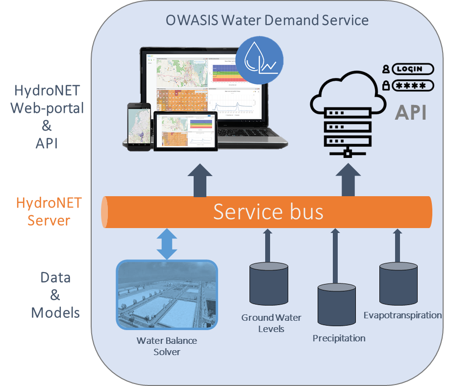
The service will be developed using the price winning HydroNET platform. To do so, the required hydrological data sources will be connected to the HydroNET server. On the HydroNET server, algorithms and models are used to calculate the soil water storage and the water demand. The information is presented to the end users in interactive maps and graphs through a regular web-browser, accessible via desktop, tablet or mobile phone. For more advanced users the information can be accessed through the API.
Space Added Value
Remote sensing technologies (Earth Observation) have proven to be extremely useful and essential in acquiring relevant data for the Soil Water Service (SWS) and will continue to be for the Water Demand Service. SatEO provides the necessary transboundary data source at the required level of detail for the services to be used in operational context.
• SatEO based evapotranspiration imagery, as made available by SAT WATER, is used as a forcing to the hydrological model underlying the SWS and WDS. This innovation was introduced in the OWASIS Demonstration Project - usually a hydrological model calculates the evapotranspiration based on static land use data - and has shown to be of critical importance to the quality of the SWS.
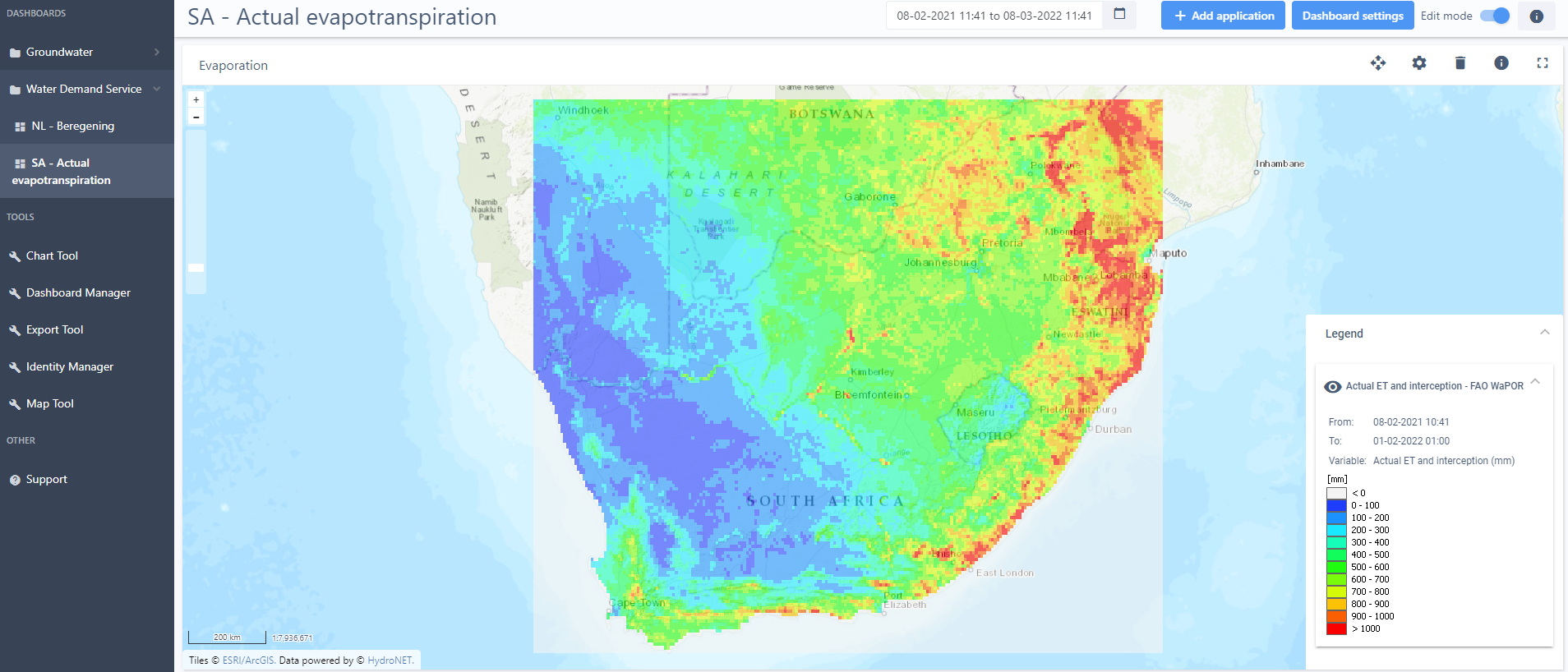
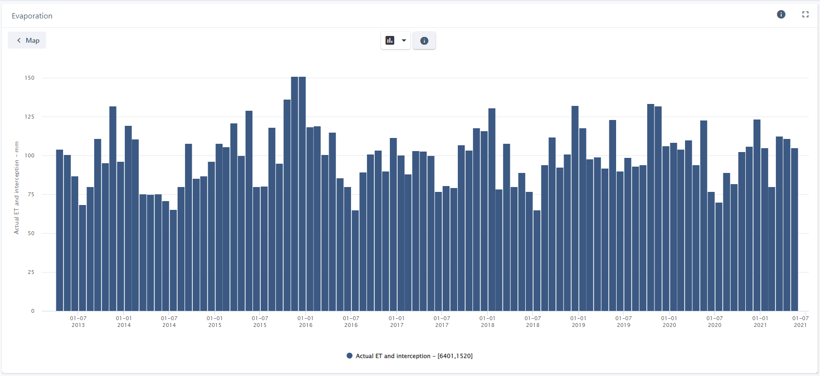
• The project makes use of WaPOR database as made available by the UN-FAO (http://www.fao.org/in-action/remote-sensing-for-water-productivity/en/). This database provides SatEO based evapotranspiration information for Africa and the Middle East. The use of this data will be demonstrated in South Africa and can be used for upscaling to the continent.
• Weather forecasts are of pivotal importance for creating a window of opportunity for end users. The weather drives all atmosphere land interactions including the crop water use. Having access to reliable weather data is therefore of key importance. The process of generating weather grids strongly relies on input information from a variety of satellite datasets including satellite derived precipitation and evaporation estimates.
A broad range of satellite imagery is used in the process to generate the weather forecasts and actual evapotranspiration.
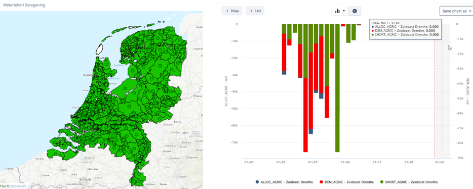
Figure 1 displays one of the configured dashboards. On the left panel an overview of the current status of water availability for irrigation purposes is displayed. A green color indicates that the water availability is sufficient to provide the water demands. On the right panel more detailed information of a random area is displayed. It shows the demands and availabilities of water for irrigation purposes over time, which in turn are used to calculate the status as displayed in the overview map.
The second development during the project was the integration of globally available hydrological information in HydroNET which can be used by water managers for mitigative reduction of drought impact (Figure 2 and Figure 3). By including globally available information in the Water Demand Service the scalability of has drastically improved.
Current Status
Achievements
-
February 2021: Project kick-off
-
April and May 2021: User interaction with Dutch and South African stakeholder to gather User Requirements
-
June 2021: Successful BDR and CDR
-
July 2021: User interaction with Dutch stakeholders
-
March 2022: Successful completion of SAT and start of pilot phase
-
May 2022: Launch of Dutch OWASIS website (https://www.owasis.nl)
-
June 2022: Dutch stakeholder session on pilot
-
September 2022: South African stakeholder session on pilot
-
October 2022: Successful completion of pilot phase
-
November 2022: Interactions with Dutch and South African stakeholders on pilot outcome
-
March 2023: Successful completion of project
Prime Contractor(s)