Objectives of the service
Pemberton’s Biodiversity monitoring tool paints a dynamic canvas of the natural world with every available colour and brush in the paintbox, using Earth Observation data from satellites, phones, drones and much more.
We have lost 69% of global species populations since 1970, and biodiversity loss has become one of the most significant factors in destabilising our climate. In the UK, the government seeks to recover biodiversity through natural capital schemes such as Biodiversity Net Gain (BNG). These biodiversity projects span over 30 years, opening them to risks such as mismanagement, negligence, misrepresentation, natural disasters, and unanticipated changes threaten the success of the project’s ability to deliver the intended outcomes. Thus, there is a need for transparency, accountability, and verification in biodiversity projects.
Current methods rely on ecologists manually carrying out detailed ground surveys in person which typically costs around £5,000 per site each time (Environment Analyst, 2019). This is not scalable and has led to a shortfall of over 10,000 ecologists in the UK. Our solution scales the measurement and monitoring of biodiversity through transparency, automation and digitalisation. This demonstration project is being conducted in partnership with Sainsbury’s, Ordnance Survey, and West Berkshire Council.
Users and their needs
-
Financial Industry (e.g., banks, pension funds, insurance): Financial institutions use biodiversity data to evaluate risks and investment returns associated with sustainability and biodiversity. They aim to get reliable data and reporting assistance.
-
Food Industry (e.g., supermarkets, food manufacturers): Companies in the food sector rely on biodiversity data to assess the sustainability of their supply chains and to meet regulatory and consumer demands for responsible sourcing and environmental stewardship.
-
Corporates: Corporations across various sectors utilize biodiversity data to monitor their environmental impact, maintain compliance with sustainability standards, and enhance their corporate social responsibility (CSR) initiatives.
-
Landowners: Landowners use the data to understand the ecological value and sustainability of their land, making informed decisions about land use, conservation, and environmental impact mitigation.
-
Environmental Organisations (e.g., rewilding organisations): These organisations leverage the platform's data to track biodiversity trends, plan rewilding efforts, and measure the success of restoration projects, driving their conservation goals.
-
Farmers: Farmers contribute data through the QA App by documenting the environmental impact of their agricultural activities, sharing real-world observations that enrich the platform's biodiversity data.
-
Ecologists: Ecologists contribute high-quality, verified data on biodiversity, helping to build a robust, reliable data set that informs research, policy, and land management decisions.
Service/ system concept
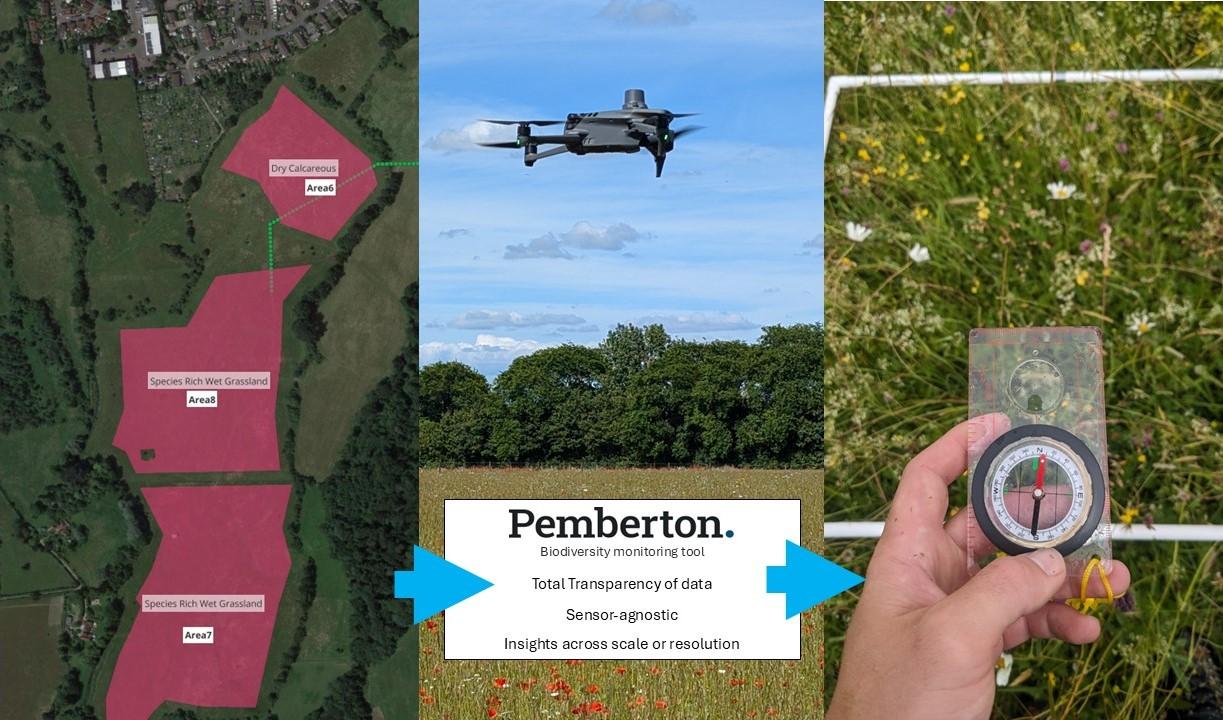
Pemberton’s Biodiversity monitoring tool is a comprehensive system that allows users to monitor, report and verify flora which essential for healthy ecosystem creation. Pemberton have designed a digital platform which provides non-technical insight on the condition of nature, powered by trustworthy and transparent data. The automated AI data pipeline can process satellite imagery, drone imagery, ecological data, or other useful information into analysis ready datasets.
Users have the option of self-service access to the Data-as-a-Service (DaaS) portal, regular reports and consultation services, or a mixture of both the DaaS access and consulting advisory services. Additionally, users can obtain training and guidance on how best to use the Pemberton Biodiversity Portal and how to interpret the data.
Space Added Value
This is a new and interesting way to use space-based assets to collect and share data that can help and act as a market-making solution to improve human knowledge and understanding, which improves global biodiversity in the long run. Space-based imagery from 4 band Satellite data from Planet and Sentinel 2 is fed into this project's larger scale algorithms to provide routinely updated information on changes over time. The Copernicus hub is a freely available data source for accessing ESA satellite mission data from its Sentinel programmes.
Current Status
Pemberton has completed our ESA funded biodiversity demonstration project, and we would like to extend our thanks to everyone at the European Space Agency, the UK Space Agency, and Lloyd’s of London for their support in bringing our technology and products to an exciting stage ahead of 2026.
You can download our Biodiversity White Paper at the link below. We also invite you to sign up for updates as we continue our journey toward becoming an MGA or cover holder, helping accelerate green finance through insurance solutions complemented by wrap-around services and explainable AI.
Prime Contractor(s)