Objectives of the service
The interdisciplinary approach proposed by the POMERIUM project will be applied to the test site of Rome, UNESCO World Cultural Heritage. The smaller area of interest (AOI) within this boundary will represent the test areas for the foreseen scenarios that the project aims to investigate.
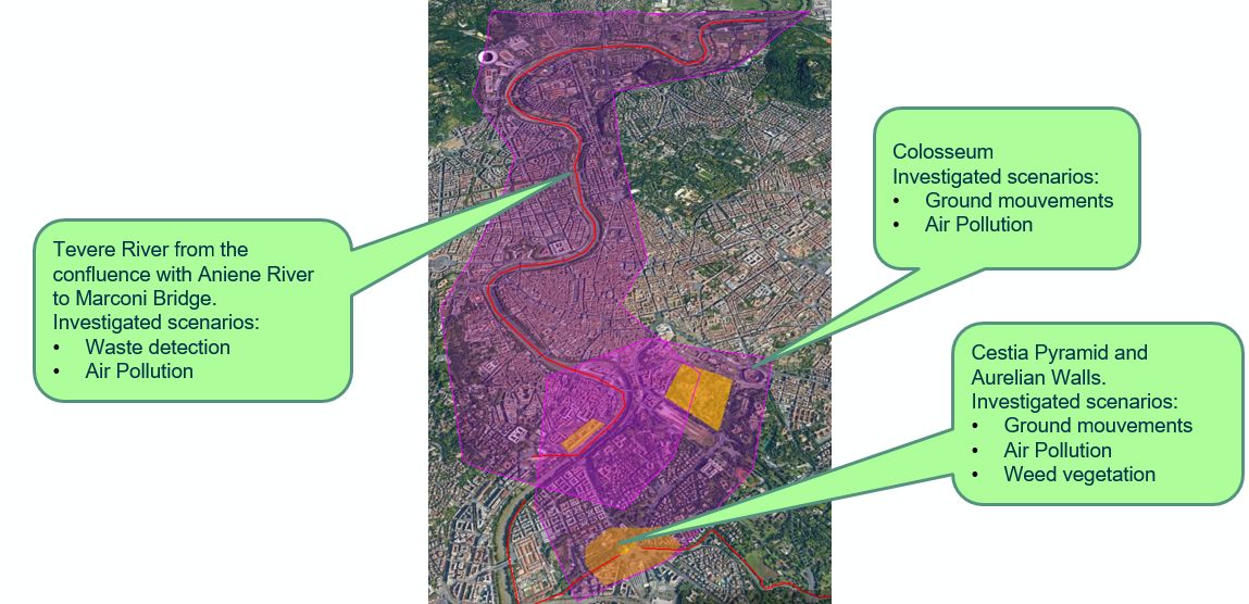
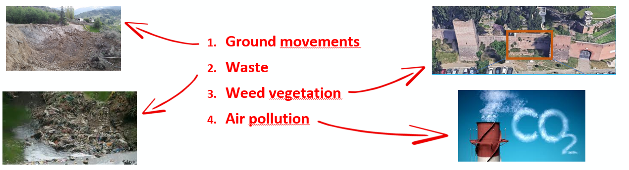
The Pomerium System aims to support managers of the site in their ordinary and extraordinary prevention and maintenance activities, by giving them access to a wide set of data and services in a simplified and centralised way. The scenarios considered and investigated by Pomerium are exemplified in the following figure:
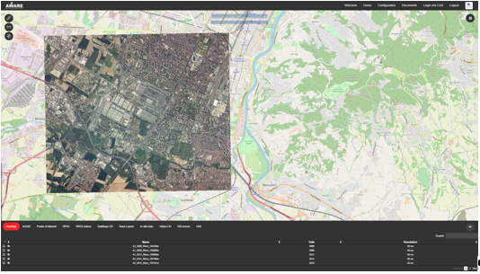
Each scenario will beneficiate of a common web platform in order to store, maintain, and analyse different kinds of data. E-GEOS will offer the availability of its AWARE (Agile Watching of Assets and REsources) platform as a unique point of access to the collected information, able to allow easy data research (it integrates the instruments to visualise and analyse interferometric data, raster images, RPAS videos, change detection analysis and so on) and so to enable the user to perform integrated analysis on the context or on single elements of interest. AWARE also allows the user to upload his own alpha-numeric and cartographic data, to add value and information contents to the already present dataset.
Users and their needs
The key customer segments targeted by our service are:
-
Central and Local Authorities responsible for CH: they are the main customer’s segment addressed by Pomerium; in fact, in all Countries the CH conservation and management is committed to Public Entities with precise competences on the territory of competence.
-
Professionals and CH experts: they often working as consultant for Public Entities or operating on CH.
-
Scientific Institutions (such as the Project Partner CISTeC) working the area of CH management are additional beneficial users of the service.
In particular, the Reference Users of Pomerium are:
-
Sovrintendenza Speciale Archeologia, Belle Arti e Paesaggio di Roma (territorial Public Entity depending from Ministry of Culture (MIC)
-
Parco Archeologico del Colosseo (dedicated Public Entity depending from Ministry of Culture)
-
Soprintendenza Capitolina di Roma (territorial Public Entity depending from Rome’s Municipality).
The main benefits of the proposed system for addressed users are related to the unification and standardisation of the knowledge about CH.
Since the responsibilities of CH management are often fragmented, this involves a fragmentation in the ownership of the data and often a difference in their format and a general difficulty in disseminating the content and in exploiting the derived information. The fact of making the use of existing knowledge of CH a common factor through a single access point, increases the decision-making and reaction capacity for interventions on the assets.
Furthermore, the fact of interacting through a single system, potentially standardized with a central character, facilitates or development of skills and methodologies of action and common transversal analyses between the different players at stake again in favour of a correct management of the asset.
Service/ system concept
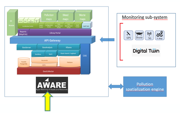
Pomerium is conceived as a unique modular system giving access to a significant collection of relevant data about the investigated CH and to a set of services able to support the Managers’ responsibilities. The allowed users may use the system to achieve a better knowledge of the status of the CH to ask for dedicated services (one or more) to satisfy their exigence. The main innovation point is the integration of monitoring and prediction technologies that, at present, are available on the market as singular services, without any operational and scientific integration between them. A further important key point is the availability of the last generation cartographic platform AWARE as a unique point of access to Pomerium data and services.
Space Added Value
Pomerium will use the following Space Assets:
-
Data from VHR SAR constellation Cosmo SkyMed. Such data represent the input to the INSAR processing chain, applied for the elaboration of displacements maps foreseen in Stability scenario. This methodology can produce very high precision results (millimetric accuracy) on wide areas and with a limited effort.
-
Data from VHR optical satellites. Optical VHR satellite data may be used in combination with other remote sensing data (mainly RPAS) to track the changes in soil use in the Waste scenario.
-
Satellite connectivity between on field devices and AWARE (when 4G/5G network is unavailable).
Current Status
The demonstration project concluded successfully in September 2022.
The collection of User Requirements (UR) and the definition of the high-level System Requirements (SR) have been completed.
During the UR collection phase, the following meetings have been held with the Reference End-Users:
-
15th and 23rd October, 2020 with Soprintendenza Speciale
-
21st October 2020 with Parco del Colosseo
-
16th December 2020 with Sovrintendenza Capitolina.
Furthermore, on 20th January 2021, a Technical Note containing a description of the project and a questionnaire aiming at collecting the UR has been distributed to the end-users on the website and the answers have been collected and analysed.
The project website (public and private area) is online and continuously kept updated.
The method and format of the data ingestion by AWARE (RESTful web service exchanging JSON formatted request/response) have been defined. The web services for data transferring from on-site acquisition stations to AWARE have been also developed.
The IoT acquisition stations and sensors to be used within the project during the pilot and as reference for the service have been defined. The procurement has been also completed. Four Acquisitions Stations for Pollution (equipped with sensors for physical and chemical parameters) have been installed at Colosseo and Piramide Cestia target sites since July 2021. One Acquisition Station for Wind/Meteo has been installed at Colosseo since August 2021. Three Acquisition Stations for Stability have been installed at Mura Aureliane target site starting from mid-April 2022. So far, approximately 4.7 million records have been acquired. Several flights have been done on all the target sites (Colosseo, Piramide Cestia, Mura Aureliane, Fiume Tevere, …)
The AWARE Platform has been deployed in production, and the IoT Acquisition Stations and the Drones are publishing on it the data they acquire in near real-time using 4G/5G network.
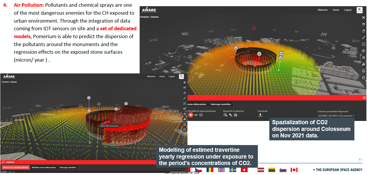
All the foreseen processing chains of the different data acquired on-site are also active on AWARE, in particular the modelling of the pollution and the modelling of the regression effects in exposed materials such as marble and travertine (see an example in figure below).
Several Communication Events have been held. In particular:
-
A Press Conference at the Italian Ministry of Culture on 14th June 2021 for the “Presentazione dei Progetti ESA 5G for L’ART e del MoI ESA- MiC per il monitoraggio e conservazione dei beni culturali immobili”.
-
A Live Demo of the project installations at Colosseo target site on 10th March 2022 to the VII Commission of the Italian Senate.
-
Presentation of the project at LPS 2022 on 26th May 2022 in Bonn, Germany.
-
Presentation to AIT Conference in Bologna, 22nd-23rd September 2022.
-
Presentation to Earth Technology Expo 2022 in Florence, 5th-8th October 2022
The training for the End-User on the use of the AWARE Platform has been conducted within April and May 2022.
Prime Contractor(s)

Subcontractor(s)