
Objectives of the service
DataCosmos is Open Cosmos’s multi-satellite data platform that combines high resolution satellite imagery and advanced visualisation tools to provide detailed insights for better decision making. The platform allows tasking the OpenCosmos satellites to receive actual data, integration of third-party data, consulting the catalog for archived data over the world, and executing insight applications using satellite images as inputs to generate useful information for decision making.
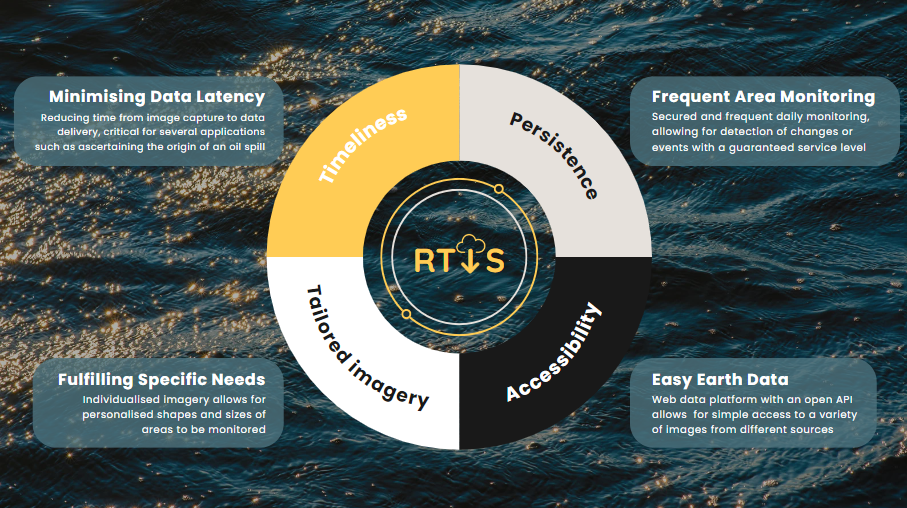
The primary objective of this project is to enable DataCosmos to generate near-real-time images and insights which can be used for monitoring oil spills and sea state conditions. Our service aims to solve the following key issues from the customer:
-
Rapid delivery time: Minimising data latency.
-
High revisit: Regular monitoring of locations.
-
Accessibility: User-friendly platform for data and insights information access.
Users and their needs
Taking in account the capacities of the platform mentioned before, the targeted user communities for DataCosmos are segmented across the value chain (images, insights development, end users), each benefiting from the platform’s unique capabilities.
Data Provision/Resellers
These users are spread across various countries, including Spain, Portugal, Peru, Paraguay, and Ethiopia. These users require access to diverse satellite data sources through a single platform, the ability to develop and deliver custom algorithms and applications, and the integration of existing applications to add value.
DataCosmos addresses these needs by offering a unified platform that aggregates satellite data from multiple sources, providing easy access to a wide range of datasets. It enables these users to develop and deploy custom algorithms, enhancing the value of the data they offer to their clients. Furthermore, DataCosmos allows for seamless integration of existing applications, enabling resellers to extend their service offerings and meet specific client needs.
Data Analytics Companies
They operate globally, with examples including NAX and Orbital EOS in Spain, VITO in Belgium, Carbon Space in Ukraine, Rezatec and Kayrros in the UK, and agriBORA in Kenya. These companies often specialise in specific domains, such as agriculture, or diversify across various sectors. They rely on satellite data for analytics and generating actionable insights.
DataCosmos supports these companies by providing access to high-quality satellite data tailored to their specific domains. The platform allows them to either specialise in niche areas or diversify their offerings across multiple sectors. With its powerful analytics tools and integration capabilities, DataCosmos helps these companies generate actionable insights, enhancing their service delivery to clients worldwide.
Multinational Corporations
They are found across various countries, including Spain with companies like Acciona, Red Eléctrica, and Técnicas Reunidas, needing reliable data integration and analytics. These corporations also require engagement and support due to their organisational complexity.
DataCosmos meets these needs by delivering robust data integration capabilities, ensuring that satellite data is seamlessly incorporated into their existing workflows. The platform’s advanced analytics tools provide actionable insights that drive decision-making across different business units. Additionally, DataCosmos offers tailored support and engagement strategies to navigate the complexities of large organisations, ensuring successful implementation and ongoing support.
Governments
These users can be found in countries such as Spain, Portugal, Peru, Paraguay, and Ethiopia. They need to provide services to national and regional organisations, rely on reliable and timely satellite data for policy-making and operational decisions, and coordinate with internal data analytics teams.
DataCosmos provides these governments with the reliable and timely satellite data crucial for informed policy-making and operational decisions. The platform’s ability to integrate with national and regional systems ensures seamless data flow and collaboration. Moreover, DataCosmos facilitates coordination with internal data analytics teams, offering tools that enhance their capabilities and support the execution of government initiatives.
Challenges:
-
Ensuring low-latency, high-resolution data delivery.
-
Tailoring solutions to diverse user requirements.
-
Engaging with large, complex organisations and governments.
-
Maintaining accessibility and ease of use across different user expertise levels
Service/ system concept
Oil spill monitoring:
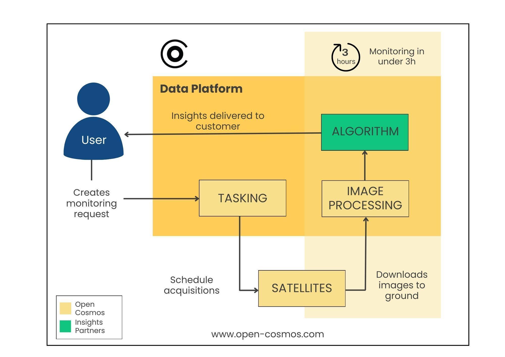
For oil spill monitoring, we aim to deliver high-resolution imagery within three hours of an oil spill, identifying area, volume, and possible source. Regular monitoring utilises Sentinel-2, Sentinel-1, and Landsat-8/9 satellites, while low-latency monitoring leverages Open Cosmos satellites like Menut, Platero and Hammer.
Water turbidity monitoring:
For sea state monitoring, we continuously monitor sea conditions such water turbidity to automate maintenance and improve reliability around desalination intakes. Regular monitoring employs medium-resolution data from Menut, Platero, Hammer, Sentinel-2, and Landsat-8/9. Radar imagery from Sentinel-1 detects water leaks in pipelines.
The capabilities provided by our service include timely, detailed satellite images for quick response and analysis, a continuous data feed for regular assessments and immediate action when anomalies are detected, and the integration of various data sources to offer a comprehensive view of environmental conditions, enhancing decision-making and operational efficiency.
Space Added Value
The Data Cosmos platform integrates a range of space assets to provide comprehensive, timely, and cost-effective monitoring solutions. Currently used satellites include Sentinel-1, Sentinel-2, Superview-1, and Landsat-8/9. During the project, additional satellites such as Open Cosmos Menut, Platero, Hammer, and others will be incorporated.
Added Value of Combining Space Assets:
-
Persistence and Timeliness: By combining data from multiple satellites, we ensure frequent revisits and timely updates, crucial for applications like oil spill monitoring and sea state analysis.
-
Cost-Effectiveness: Utilising existing satellites and integrating IoT data minimises the need for an extensive constellation, reducing costs.
-
Enhanced Monitoring: Different sensors and satellite types (e.g., optical, radar) provide complementary data, improving detection accuracy and reliability.
Example Pilots:
-
Oil Spill Monitoring: Regular monitoring with Sentinel-2, Sentinel-1, Landsat-8/9, and low-latency monitoring with MANTIS, Menut, and Hammer data ensure timely oil spill detection.
-
Sea State Monitoring: Sentinel-2, Landsat-8/9 for regular monitoring and Sentinel-1 radar imagery for detecting water leaks, supplemented by MANTIS, Menut, and Hammer.
This multi-source approach offers significant advantages over current methods by improving revisit rates, data accuracy, and cost-efficiency.
Current Status
The RTIS has concluded the project tasks and pilots’ execution, reaching 90% improvements in delivery time in both images and insights, enabling near real time response to critical situations throughout the world.