Objectives of the service
Local authorities and civil protection agencies often start acting when an emergency has already happened and are not able to act beforehand due to missing knowledge of the event itself. With our integrated Safety Alert and Flood forecasting Engine for Brooks and Creeks (safeBACK), we will provide a service that is able to automatically generate and distribute alerts to authorised users. These alerts include a probabilistic flood forecast for water bodies of interest and the expected water levels. Real-time measurements of the water
level, precipitation forecasts over different time intervals, Earth observation data and forecasts of expected water levels are combined and included in the service to enable users to get an overview of the flooding situation. This increases the readiness for action of local authorities and civil protection agencies.
Users and their needs
safeBACK users, including local authorities, civil protection agencies, and emergency responders, need reliable, real-time information to make quick, informed decisions in flood situations. They require accurate alerts and forecasts that allow for early action to minimize risk and protect communities. Their needs include easy access to up-to-date data on water levels, precipitation, and flood risks, along with clear guidance on potential impacts to streamline response and preparedness efforts. safeBACK addresses these needs by delivering timely, integrated flood alerts and forecasts, enhancing their ability to respond effectively before and during emergencies.
Service/ system concept
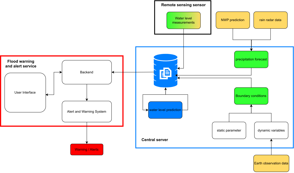
There are three major components involved in our technical solution: Flood warning and alert service, central server, and remote sensing measurement device. The flood warning and alert service will be an application provided to the user and consists of a frontend, backend, and an alert message system, which sends alerts to authorised receivers. The central server is the heart of the service, which gathers data from different sources, pre-process, and stores the data. The central server also performs all computations to get the required parameters and information for the service. The central server has different interfaces, and can download data from external sources (e.g., Earth Observation data, numerical weather prediction (NWP) data, rain radar data) and the remote sensing measurement device with Global Navigation Satellite System (GNSS). The remote sensing measurement device is the third component, which provides the required water level data for the service.

Space Added Value
The service leverages satellite positioning and remote sensing for monitoring small waterways. Satellite Earth Observation data establishes boundary conditions for each brook or creek, considering unique geographic characteristics to estimate flooding potential. Land cover is evaluated using Corine products from the Copernicus Global Land Service and updated as needed. Additionally, soil moisture data from the Copernicus Global Land Service and ESA’s SMOS satellite are integrated to assess flooding risks, with updates provided regularly. Satellite telecommunications ensure connectivity for alerts and sensor data in remote areas. Accurate flood prediction depends on analyzing the land cover and soil moisture of each catchment area using reliable Earth Observation data. GNSS aids in determining the precise location of sensors.
Current Status
After a successful User Requirement Workshop we are now going forward with defining the technical architecture and Mock-Up accordingly. Also, we are currently working on our business and marketing strategy. So if you are interested, please contact us!


