Objectives of the service
This feasibility study examined the use of HAPS for end-user services, specifically for maritime services to support regional agencies including coast guard, outer border management and security. It identified a HAPS solution that could significantly improve and expand their awareness capabilities across large maritime areas.
Today, these agencies have limited situational awareness and currently rely on expensive use of planes, helicopters, boats, which are limited in range and satellite data to patrol vast areas. Consequently, they’re not able to fully enforce or protect these areas whether saving human lives, mitigating oil or chemical spills, fisheries protection, security threats and other illicit or trafficking activities.
The findings of this study indicate that using lighter than air HAPS (airships) that can carry existing sensor equipment could significantly improve maritime awareness and at the same time deliver large operational cost savings. An airship carrying advanced cameras, sensors as well as maritime VHF receivers, would provide permanent coverage and deliver high resolution, detailed assessments of crafts and objects of interest of almost any size. This largely automated capability would significantly reduce total search hours flown, saving hundreds of millions of euros every year whilst also boosting their operational abilities to save more lives and better protect key maritime areas.
Users and their needs
This study focused on EMSA, Frontex, SatCen and Member State coast guards’ operating needs. Through interviews, these stakeholders have identified clear needs for:
- Increased maritime awareness delivered in a more holistic infrastructure in which data sources can be integrated across platforms and data types, typically within a GIS framework
- Long-endurance capabilities with a lower price point than existing solutions
- Long-range ISR (Identification, Surveillance and Reconnaissance) capabilities at high NIIRS (National Imagery Interpretability Rating Scale) level
- Relay solutions for controlling and communicating with RPAS as well as relay of maritime VHF data
- All weather and night-time and IR ISR capabilities
The services are intended for key Mediterranean states that form the outer maritime borders of the EU including Spain, France, Italy and Greece.
Service/ system concept
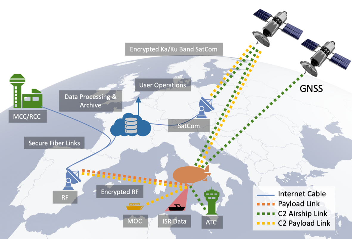
Sceye developed the CONOPS shown that delivers persistent, wide domain of awareness services through the use optical data and the relay of radio communications, which together enable detailed, real-time situational information to be provided to end-users. This will be in the form of GIS-grade information, such as the position of ships derived from their broadcast data layered with optical input to accurately position and validate the craft’s identity, vectors and other features of interest. The sensor data is delivered to a data processing centre through ground-based communications receivers as well as satellites, on high-speed links. Processed data will include auto-tracking of potential threats, which may be identified by their lack or incorrect transmission of position correlated with size or unusual behavioural traits. These services will provide users with significantly deeper awareness over sovereign areas whilst reducing the use of craft and personnel and operating risks.
Space Added Value
Service capabilities rely on the use of existing space-based infrastructure for their operation. Position, Timing and Navigation (PNT) services and satellite communication services (SatCom) allow secure command and control (C2) and payload data links to be established and pilots to remotely fly HAPS craft to any location on the globe.
Satellite communications will be used for:
- C2: By relaying HAPS C2 communications from ground control centers, HAPS can be deployed and remotely piloted beyond radio line-of-sight (BRLOS) for global HAPS missions. Remote sensing data collected by HAPS’ payload can also be relayed via satellite communications back to ground operations when in BRLOS conditions.
- Backhaul: Satellites will be used to relay the data from mission payload equipment and communications devices (4G/5G/Broadband) between the gateways and the HAPS forming one element of a hybrid architecture
Satellite navigation will allow HAPS to be piloted without using ground-based navigation systems. Navigation services will also be used for providing Earth observation payloads with precise geo co-ordinates, as spatial accuracy is critical for end-user services.
Satellite payload equipment – a large spectrum of instruments that have been funded and developed for data collection missions can now be quickly and economically deployed (essentially as COTS) for new commercial missions given Sceye’s large payload capacity.
Image and signal processing – Sceye will leverage the rich ecosystem of highly specialised data processors funded and developed for a growing range of space missions. Sceye will consume a range of their services within its product sets to deliver a new generation of products to customers. In addition, Sceye will use the existing large datasets acquired from Sentinel/Copernicus/Landsat and others to enrich and improve the quality of product offered in market.
The high temporal, spectral and spatial resolution data captured by HAPS sensors will enhance established value-add services that exploit data captured by existing Earth observation satellites such as the Copernicus Sentinels.

Figure 1: Earth observation data from Copernicus in support of user operations and services
Calibration / Validation: Additionally, the ability of LTA HAPS to return to base after a multi-month mission means they are ideal platforms to support satellite sensor testing (Calibration/Validation) ahead of deployment to space. Future missions include The Earth Explorer - Fluorescence Explorer (FLEX) and Copernicus Sentinels.
Current Status
The successful completion of this feasibility study has provided the basis for Sceye to proceed with developing a formal Maritime Services Demonstration program for ESA and agency customers.
The study successfully established sufficient technical, operational, services capability to enable the development of a detailed demonstrator program. Detailed program plans are now underway that include flight, payload services, mission equipment, data processing which together will show the viability, superior capabilities and cost efficiencies of HAPS as a platform for Maritime Services.
The proposed demonstration services are a key milestone in Sceye’s own demonstrator program which is both set to make aviation history and progress type certification for LTA HAPS which naturally benefits the wider communities in HAPS, Space and Services.
Prime Contractor(s)
Subcontractor(s)