Objectives of the service
Throughout the project, there will be an integrated advanced solution managing wide green areas (e.g., Nature reserves, urban parks) with a significant reduction of events such as fires, crime (assaults, robberies, drug dealing, prostitution, eco-terrorism, vandalism …) and other administrative offenses (illegal building, illegal dump, etc...).
The solution improves protection of environmental resources with an overall better usability of green areas by citizens. This is possible through the continuous Satellite vegetation health monitoring that, in turn, allow for a more effective and focused green maintenance. Citizens also have direct services accessing open data generated by the proposed solution (e.g., meteo data, video as per end user requirements).
Users and their needs
The target market typically consists of local/central public administrations and private organizations managing large green areas where crime, administrative offenses and fire have a social and economic impact and management prompts to increase citizen usability. Green areas may be natural reserves, archaeological sites, urban parks and forests.
The addressed target market is mainly Italy, Europe and America.
Focusing on early fire detection systems, “in 2017 wildfires, burnt over 1.2 million ha of natural lands in the EU and killed 127 people among fire fighters and civilians.
The European Forest Fire Information System estimated losses of around 10 billion euros caused by these fires. The fire weather danger is expected to increase in Europe due to climate change, and will be increasingly characterized by extreme fires destroying vast areas with long-term impacts.
Italian actual market of early fire detection systems is estimated at 90M€/year that can be scaled proportionally at over 400M€ / year in Europe considering burnt areas and country available budget. The market size of the overall solution is much wider considering the additional functions for crime, offenses, green health monitoring and citizen signalling.
Service/ system concept
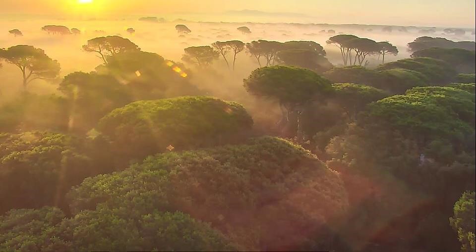
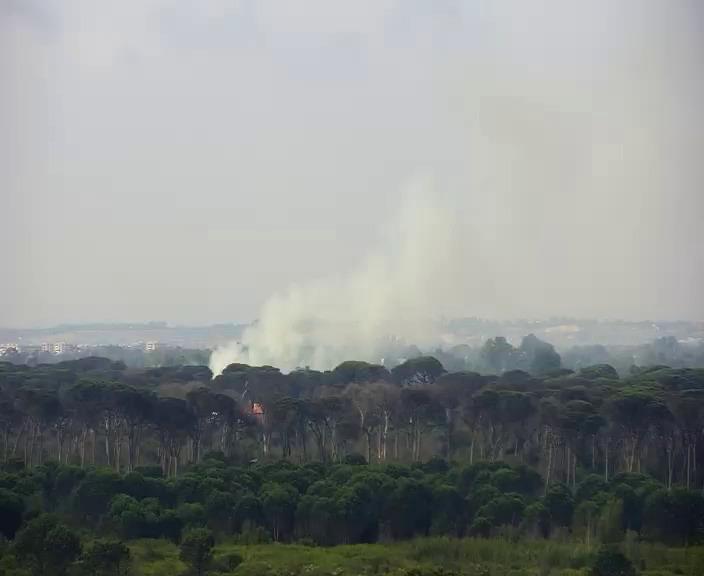
The project is focused on Law Enforcement and Emergency Response along the Castel Fusano Pine Forest reserve, through the monitoring and prevention of fire and illegal actions in forestall areas.
This is obtained through the design and following deployment of breakthrough technologies and assets as:
-
Satellite assets (earth observation) for fire prevention
-
Autonomous Drones
-
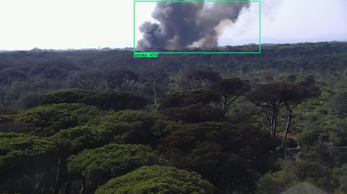
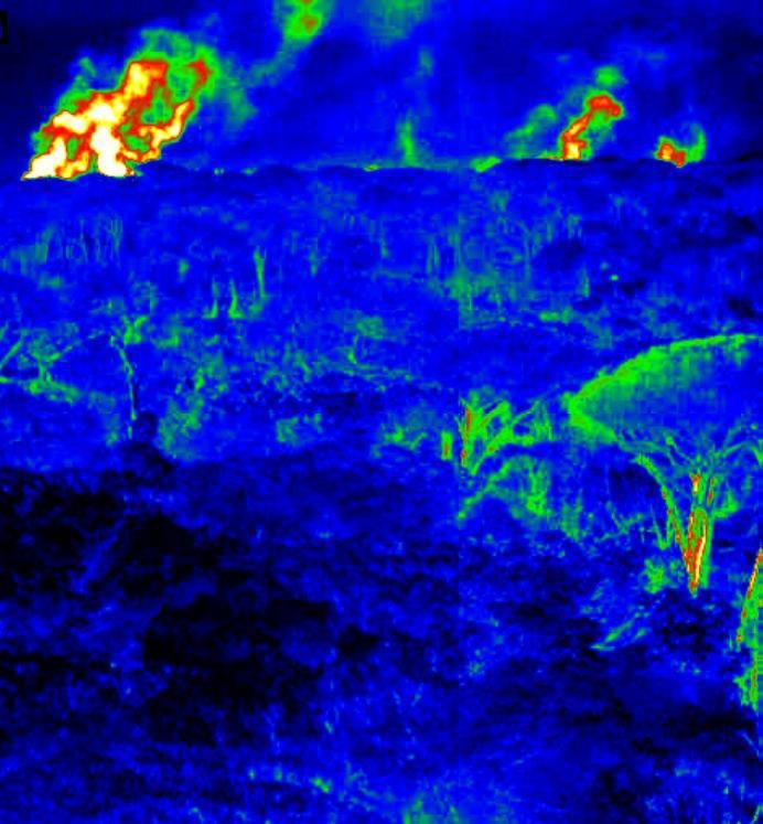
High resolution based integrated IR-Visible, AI Powered fire detection systems
-
AI powered Security Gates with plate readers
-
5G communication
-
Dedicated algorithms (AI based).
-
Distribute control rooms for stakeholders
The relevant architecture depicted in the picture below.
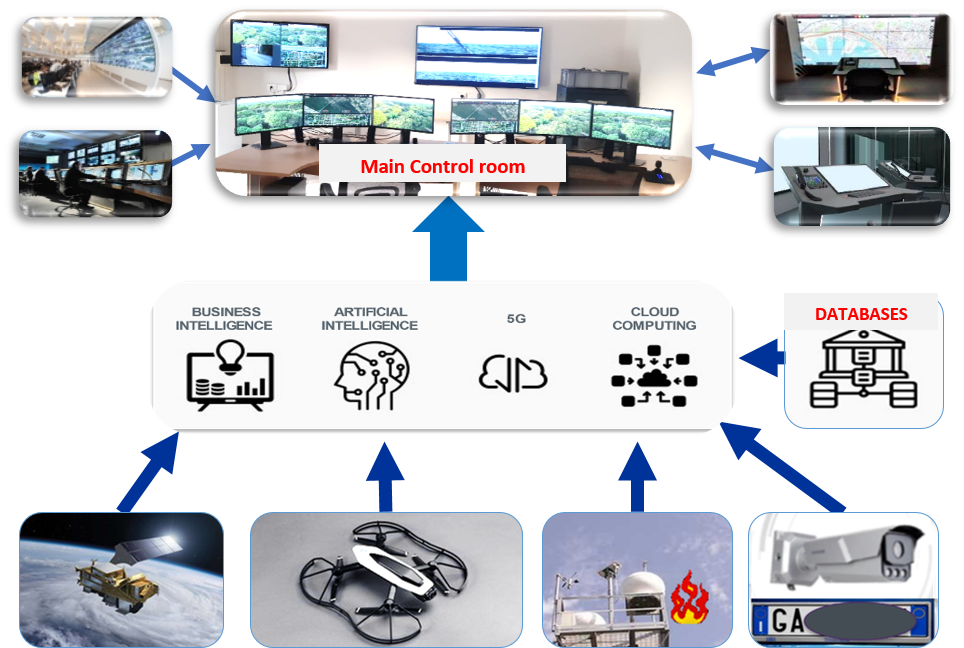
Artificial intelligence and big data analysis are used to collate, filter and correlate information from a range of different sensors and other sources to present police forces with a real-time overview of the situation in the park, supporting rapid and high-quality decision making and interventions.
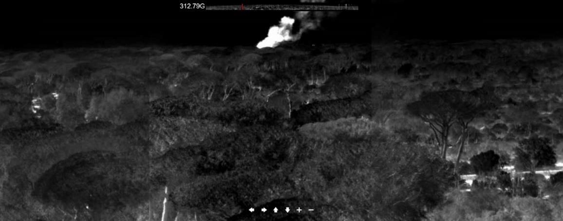
Drones will patrol and collect imagery, even at night, while audio-video sensors are able to automatically detect critical events such as gatherings, gunshots and calls for help. Optical license-plate reading systems are able to recognise non-compliant vehicles. Meanwhile, firefighting systems are able to detect even very small outbreaks of fire up to 15km away and communications networks including narrowband (TETRA) and broadband (LTE and 5G) technologies are employed to coordinate interventions.
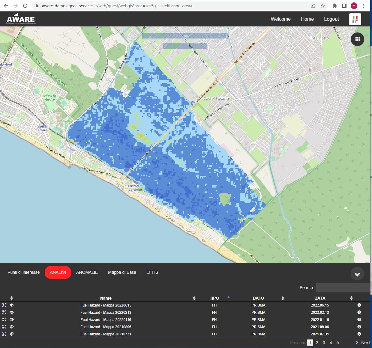
Security is supported from Space, with PRISMA earth observation satellite helping to monitor the area’s forests, spot illegal activities and provide backup communications in the event of problems with the ground-based network.
PRISMA satellite is able to use Leonardo’s hyperspectral instrument to carry out a chemical-physical analysis of the area from 615km away, providing information on the health of vegetation and allowing operators to generate a fire risk model for the area.
Space Added Value
The proposed integrated solution exploits the PRISMA (Hyperspectral Precursor of the Application Mission) asset, fully funded by the Italian Space Agency (ASI). Prisma is an Earth observation system with innovative electro-optical instrumentation that combines a hyperspectral sensor with a medium resolution panchromatic camera.
This offers the scientific community and users many applications in the fields of environmental monitoring, resource management, crop classification, pollution control.
In this specific use case, Prisma is used with a focus on the purposes of forest analysis to assess pre-fire environmental conditions and to derive data for fire prediction.
Regarding the characterization of pre-fire environmental conditions, the multiple and narrow spectral bands of hyperspectral remote sensing allow high precision approaches to determine the fuel conditions compared to the broadband multispectral one.
In particular a fire risk map integrates three different layers: ndvi (normalized difference vegetation index, plant health, chlorophyll etc), ndwi (norm diff water index, water content), ndti (norm diff tillage index, sensitive to lignin, in turn an indicator dry matter).
Prisma is a scientific precursor of a second generation Prisma operational satellite whose requirements are being studied, (e.g., revisiting time, spatial resolution, bands etc) just to make it more suitable for applications. Prisma is a near polar sun synchronous, 30 m spatial resolution, and it passes on average 2 times a month, if tasked to acquire a specific area, it can double the passing frequency, but with different camera angles. Prisma is the only hyperspectral satellite currently operational.
The calibration, validation and product development (and processors) activities involve the whole national supply chain.
Space communication an 5G is also focused to obtain a resilient and effective ICT infrastructure. In general, the various sensors connected to the network requires two out of three main features of the 5G, that is, real time mission critical services and sufficient data bandwidth in order to convey high quality images. All those features have to be supplied with high reliability. Video data from camera requires very high-quality resolution in order to detect small details associated to fire smoke at very long distances (> 20 km). This requires high data bandwidth from the various camera. At the same time, cameras have to be managed with pan, tilt and zoom at very low latency in order for the operators to have the correct feedback for fire localization and tracking. Drones have similar requirements since they convey very high-quality videos to be supplied in quasi real time in order to ensure the proper command piloting management. Cameras are also spread over the territory and wired connection are hardly feasible. The scenario is also challenging because in case of natural events such as fire or storms, conventional communications are not guaranteed.
Satellite communication and 5G may address all these requirements in order to cope limits of radio relay and fiber optics. Satellite guarantees a reliable and resilient link when conventional communication is not available, while new generation wireless communication (4G and more 5G) assures an enhanced data bandwidth with real time performances required in mission critical services.
The Ses5G experiments a multimedia hybrid network leveraging benefits from a mix of different communication technologies. Due to the area constrains, the backbone may only leverage radio relays for the backbone of the main cameras. A resilient configuration is then implemented using satellite comm, 4/5G, redundant radio relays and VPN over fiber connections over possible. 4/5G is also used for communication on network elements in communication critical areas. Cyber security is enforced by router-firewalls to secure the single network “island”.
The overall SES5G network is a hybrid network suitable to assess Sat, 5G, fiber and radio relay communications in a critical environment thus assuring real time, high data throughput and reliability.
Current Status
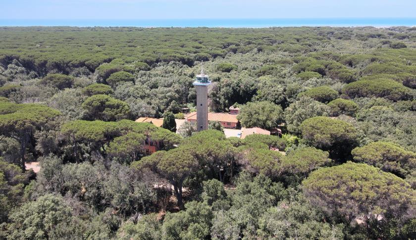
Responding to urgent customer response, the whole firefighting service has been operative starting from 15 June 2021 and it has been providing 24/7 service for the whole summer 2021 and 2022 firefighting campaign in the national natural reserve of Castel Fusano. The system includes: a fully redesigned and renewed control room, satellite data, autonomous drones, ground fire detection sensors with weather stations and visible-IR high-resolution cameras, thermal based detector and AI enabled smoke detection on visible streams. 3 mobile control rooms. Several service demonstrations have been performed at high level (Operational Director, National Civil Protection, Rome Mayor, Regional Fire brigade Director, Rome Local Police and Civil Protection Directors).
The area monitored by the system has not experienced significant events due to the prompt detection and management. Thanks to the high-resolution sensors, the solution is able to detect fire events occuring 20 km away and beyond.
The Final Review was held in July 2023.
As future steps, a Contract Change Notice (CCN) is intended and is proposed to cover the development of additional features such as new AI algorithms that will concern the crime prevention and reduction and a new telecommunication subsystem using the best radio coverage and the increased bandwidth available.
Prime Contractor(s)

Subcontractor(s)