
Objectives of the service
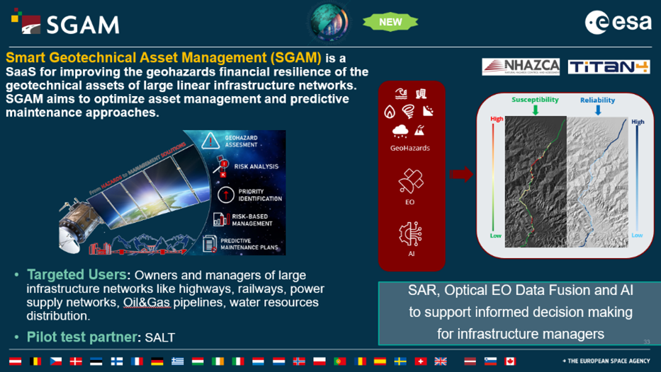
SGAM is developed and optimized to perform hazard and risk assessment on geotechnical assets which are key elements for the efficiency of many ground-based activities and their systematic management. The system aids users who need to monitor many infrastructures simultaneously and over large areas, aiming at supporting the definition of appropriate risk mitigation and maintenance plans. This is achieved through the analysis of large-coverage EO data and their integration with field measurements and inventory maps through Artificial Intelligence algorithms. The objective of this project is to create a standardized and industrialized service (Saas) that automatically assess multiple geohazards susceptibilities and the involved geotechnical assets, thus also supporting the definition of predictive maintenance plans.
SGAM is primarily addressed to the entities in charge of transport networks operation and maintenance management, who are the key target of the Demonstration Project. However, SGAM applications can be extended to any linear infrastructural network, such as Oil&Gas pipelines, aqueducts and assets related to the water supply networks, electric power distribution networks, etc.
Users and their needs
Users’ needs can be summarized as follows:
-
Multi-risk assessment, based on different geohazards and adaptability to climate changes
-
Technological improvements on predictive maintenance methods
-
Scalability and flexibility of predictive maintenance methods
-
Optimization of maintenance costs through an effective assessment of maintenance needs, based on quantitative and reliable data
-
Risk-based maintenance strategies
Service/ system concept
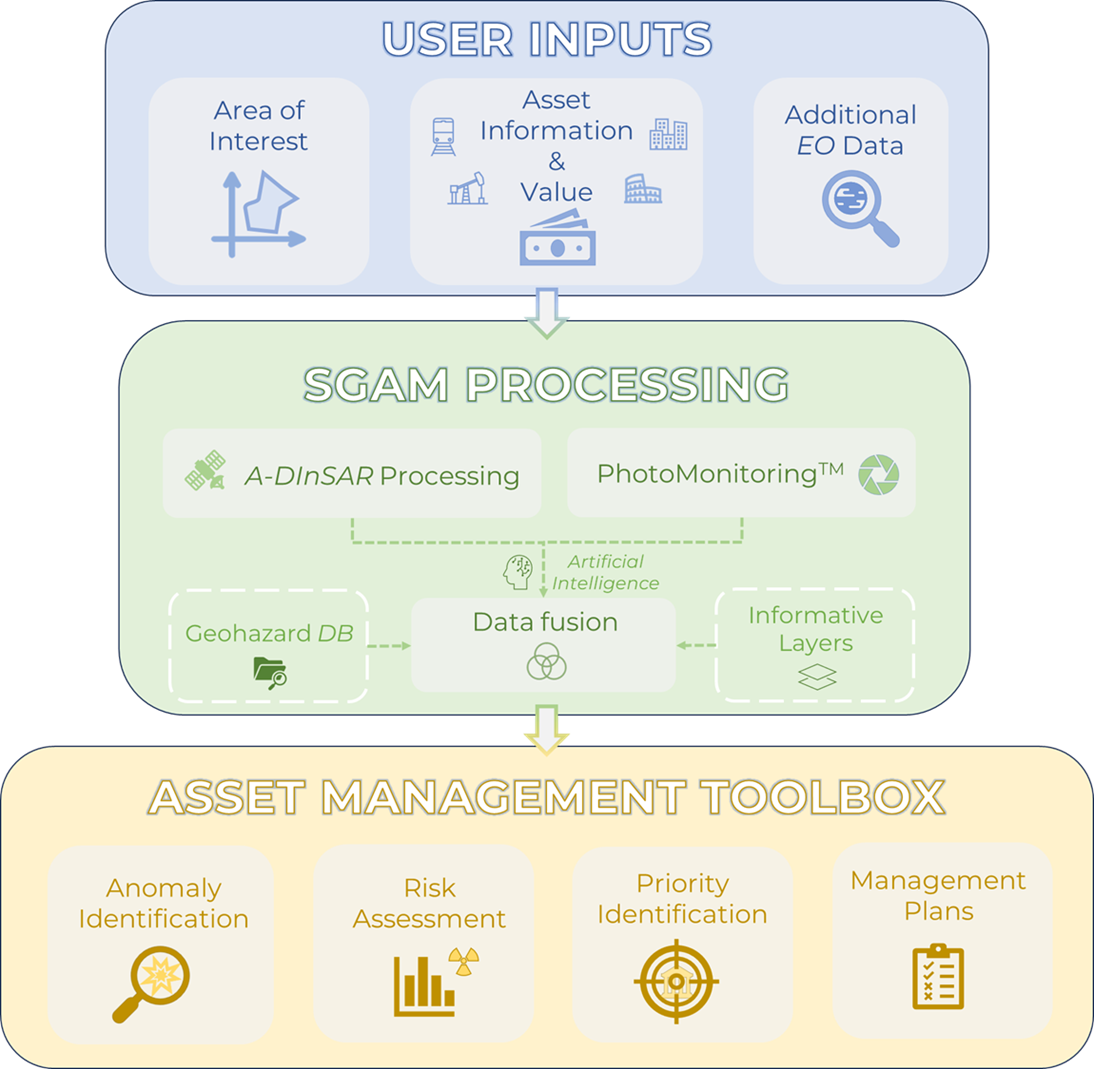
SGAM is provided through a web-based platform that runs a cloud-based Software as a Service (SaaS) and with API for the connection to the system. The users shall provide their Area of Interest. The system features two automatic processing chains (A-DInSAR module, PhotoMonitoringTM module) for the analysis of EO data. The results from the automatic analysis modules are integrated with Informative Layers and data from a Geohazard Database, and post-processed with an AI-driven Data Fusion module.
The outputs of SGAM are:
-
automatic identification of geohazards and susceptibility assessment;
-
automatic assessment of the interference between geohazards and the involved geotechnical assets;
-
segmentation of the infrastructural assets based on a priority assessment.
The output of SGAM provides users with simple and direct information that helps them prioritize and manage maintenance operations on key assets.
Space Added Value
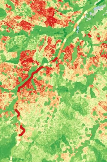
Space assets offer a great opportunity to thoroughly investigate large areas with remarkable precision, enabling the implementation of infrastructure management strategies based on up-to-date monitoring data, which helps prioritize actions effectively.
One of the greatest advantages and distinctive features of Earth Observation data is the possibility to use it for historical analyses, leveraging the vast archives of imagery available from previous decades, allowing to understand the geotechnical and geomorphological behaviour of the AOI and assess if it that may affect the infrastructures.
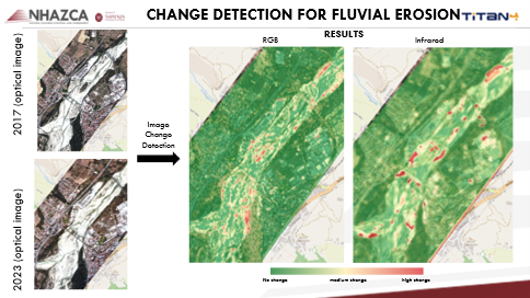
By combining and integrating A-DInSAR (Advanced Differential Interferometric Synthetic Aperture Radar) and PhotoMonitoringTM techniques, a comprehensive representation of the phenomena under investigation is achieved. Specifically, the InSAR technique enables the precise measurement of displacements in unstable areas with millimeter-level accuracy. Meanwhile, the PhotoMonitoringTM technique facilitates the identification of areas affected or potentially affected by events such as floods, fires, collapses, and more. In this way, the geospatial information provided by EO data can be suitably matched with any other ground segment spatial data, for their integration in SGAM.
Current Status
The Demonstration Project has been successfully completed with the Final Review of November 28th, 2024. SGAM got positive feedback by Pilot User, for the several implemented functionalities. Specifically, the fusion of data using multiple information from geohazard databases and A-DInSAR and the results achieved by PhotoMonitoringTM on fluvial areas close to the asset, have been particularly appreciated due to the exhaustivity of the outcomes.
Regarding the business aspect, the Demonstration Project allowed us to:
-
build up a first and serviceable prototype of SaaS, allowing to get sound and consistent feedbacks from potential customers;
-
secure the first contracts with relevant customers;
-
expand the dissemination of SGAM with large Italian companies managing highways and railways, with several ongoing meetings and possible signing of Proof of Concept;
-
define a digital marketing strategy, outline an editorial plan and updating the Business Plan with two solutions, differentiating for large and small customers, because of their different needs;
-
design and register the new SGAM logo, for supporting the brand awareness increase worldwide.