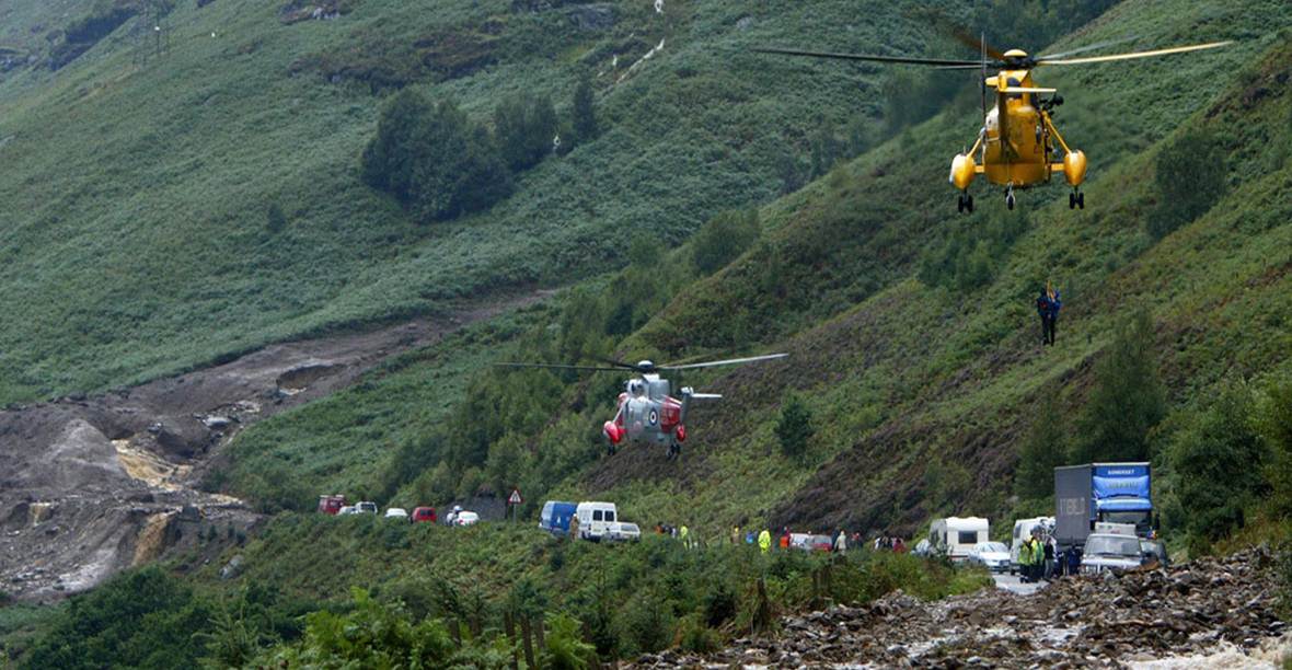
No one needs to be reminded that natural hazards abound. As we well know, areas with unstable geology, for example, are prone to rock falls and landslides, with potentially severe human and economic consequences. Whereas the effects of landslides and subsidence upon communities in mountainous and coastal areas is well known, less well recognised is the danger of unstable terrain to the transport infrastructure across wide areas of Europe.
In view of this, what tools and technologies, both on location and from space, do we have at our disposal to understand and mitigate these kinds of risks? Are there ways of identifying and monitoring unstable areas which are both effective and economically viable? Can business models be developed for offering these monitoring services to transportation infrastructure operators and other stakeholders in a cost-effective and sustainable manner?
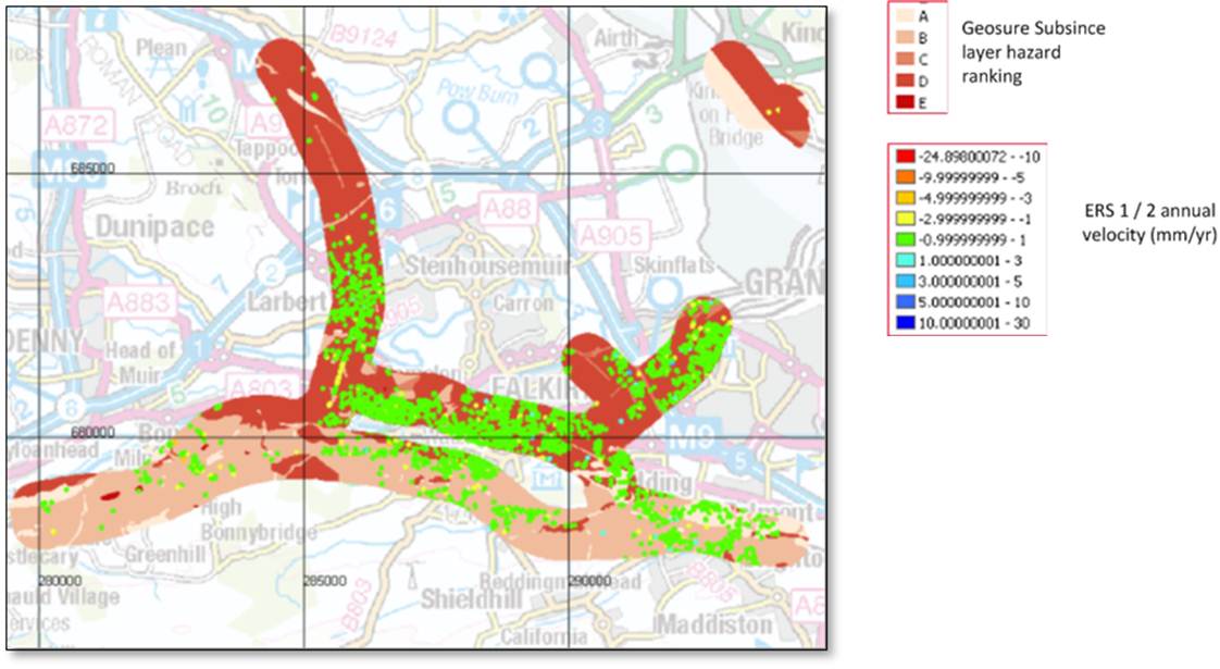
To answer these questions, two feasibility studies have recently been completed within the framework of ESA’s ARTES 20 programme. The goal of the Live Land study, led by CGI (United Kingdom), was to investigate whether the development of a suite of integrated data services could reduce the disruption and cost associated with landslide and subsidence hazards on transport networks in Scotland, managed by Transport Scotland (road) and Network Rail (rail).
Similarly, the MATIST project, led by Gamma Remote Sensing and Consulting (Switzerland), set out to examine the viability of a combination of individual technologies to provide ground motion information in the mountainous regions of Switzerland and Austria, notably the dense rail networks of the Swiss Federal Railways (SFR) and the Austrian Federal Railways (OeBB), as well as the main road network of Austria (Asfinag).
The two teams focused on whether satellite imagery, known as Earth Observation (EO) data, deployable Global Navigation Satellite System (GNSS) equipment, and satellite communications to relay in situ observations into a central management system for understanding ground motion of and around transport infrastructure is technically feasible and could provide economic benefits to end-users on a regional or national level.
Traditional tools, such as photogrammetry, and point-based local monitoring equipment, work well for specific locations, but are labour-intensive and costly to deploy. The challenge faced by the teams was to come up with techniques for monitoring potential hazards across wide areas with acceptable frequency and accuracy. One promising approach is to use maps produced by satellite Synthetic Aperture Radar (SAR) interferometry to identify potentially hazardous slopes, followed by repeat monitoring of these locations using an array of tools, with the comparatively expensive technique of near-real time in situ monitoring of unstable formations deployed only where considered critical.
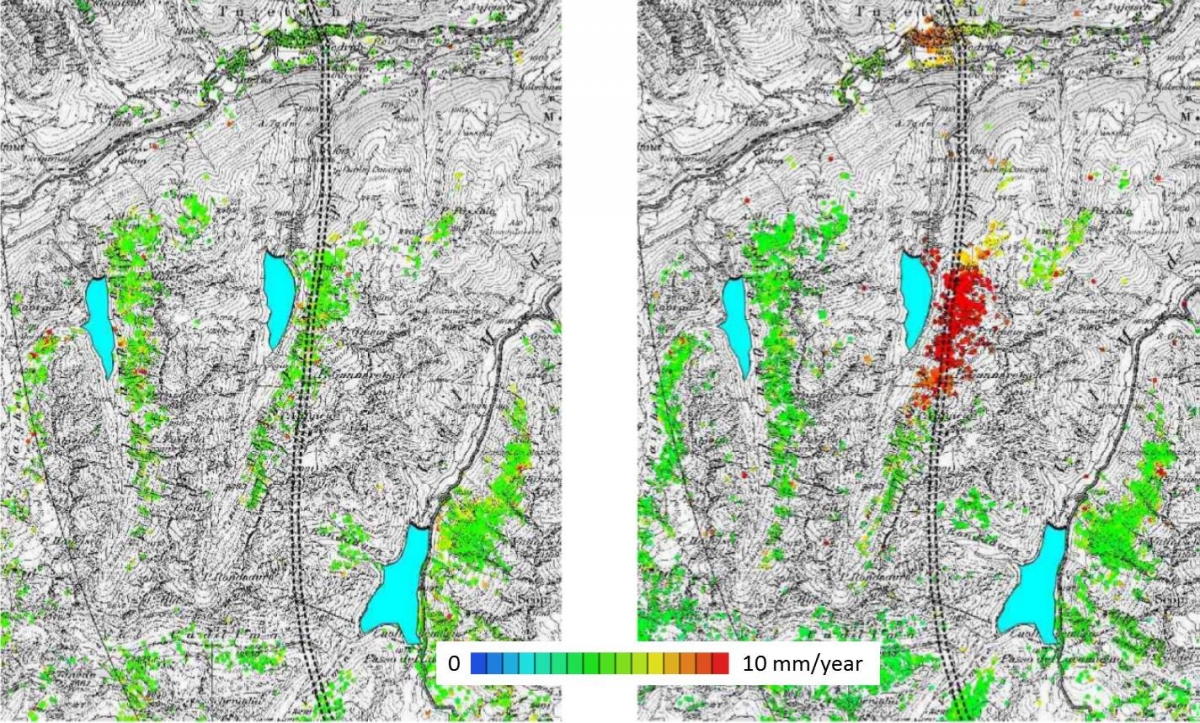
“By taking regular observations, we can now measure very small displacements across large areas,” explains Rafael Caduff of Gamma Remote Sensing and Consulting. “When we detect sudden changes in motion velocity, this indicates to us a potentially high-risk situation and that the site needs to be monitored more closely.”
“There is no single technical solution for solving the problem of monitoring natural hazards, says Rob Postema, ESA ARTES 20 Technical Officer. “But these two projects demonstrate how combining techniques such as EO data, GNSS positioning, in situ monitoring, and satellite communications results in a powerful toolset for tackling a whole range of geological challenges, enabling us to monitor ground motion risks across much larger areas with acceptable frequency.
“Both project teams worked with real users facing genuine risks from unstable geology, and upon completion of the projects, these organisations began developing concrete plans to continue using these monitoring services,” he adds.
“In coming years, I expect to see a great many more innovative applications which make use of earth observation data and satellite services for keeping a watchful eye on phenomena of ground motion and the associated risks,” Postema says.
"Live Land has been a key opportunity for CGI," observes Geoff Busswell of CGI. "ESA's role in initially engaging with the users and funding the initial feasibility study based on their requirements has been critical in enabling CGI to robustly analyse the feasibility of possible solutions. The Agency' s expertise in overseeing feasibility studies through to demonstration and operational phases has been extremely important in helping the CGI consortium to put a sustainable future vision in place for Live Land".