Objectives of the service
The objective of the services is to provide bespoke satellite-based analyses to support the management practices of Transmission and Distribution System Operators (TSOs and DSOs, respectively).
A safe, secure and reliable supply of electricity is vital, therefore the electrical grid is a crucial infrastructure. TSOs have to control the safety of the infrastructures through regular monitoring and maintenance. In wooded areas, vegetation can quickly become a threat to the network safety: a tree falling on high voltage lines or a pylon, vegetation growing underneath the power lines or branches coming too close to them. Non-authorised activities that occur in the Right Of Way (ROW), i.e. the strip of land immediately below and adjacent to a transmission line, can also pose severe risks to the infrastructures. The cost impact of traditional change detection and vegetation management services is significant. Therefore, the challenge for the TSOs is to guarantee maximum safety while striving on saving costs.
For this purpose, GMV developed pioneer services to leverage Earth Observation (EO) data and state-of-the-art Deep Learning algorithms to provide measurable and objective information on the status of the corridors along the power lines.
Users and their needs
GMV’s services are targeted at Transmission and Distribution System Operators of electricity across Europe.
The services were designed to meet users' needs, identified through conversations with the stakeholders involved in the project, i.e., nine TSOs who are members of ENTSO-E, the European Network of Transmission System Operators for Electricity.
Users have expressed the need to:
-
ensure the continuous supply of power.
-
ensure the safety of infrastructure and operators, through efficient monitoring of the network at a limited cost.
-
guarantee smart scheduling of maintenance tasks.
-
decrease the risk of network failure by efficiently managing vegetation along power lines.
-
be aware of activities that occur in the ROW.
-
rapidly deal with the impacts posed by disasters.
-
smoothly integrate new services into their work practices.
Service/ system concept
The vision for the services is to provide users with accurate information about what is happening or has happened, and the status of the vegetation in the ROW of the high voltage power lines.
The three services aiming to address the needs of the TSOs are:
-
Vegetation Management: large scale monitoring and prioritisation support for vegetation management activities (e.g., pruning, clipping) in the ROW.
-
Change Detection: detection and alert of anomalies (e.g., man-made objects, disposal of vegetation) in the ROW.
-
Disaster Management: fast provision (few days) of geospatial information in support of post-disaster management activities, immediately following a disaster impacting the energy network infrastructure.
The services strive to contribute to ensuring a secure and reliable supply of electricity, while reducing costs and enhancing management efficiency, by complementing traditional management of the energy network infrastructure with digital mapping, monitoring and change detection based on satellite observations.
During the project, several pilots were run with the users to showcase the services and the final products.
Space Added Value
The services make use of multi-source datasets where Earth Observation (EO) data are the key asset, mainly but not limited to Very High Resolution (VHR) and high resolution satellite optical imagery.
For the Vegetation Management service, GMV developed a cutting-edge model that exploits Deep Learning approaches to predict the height of vegetation from monocular satellite optical images. This model is the core of the Vegetation Management service, and the three final vector products rely upon it:
1. Average Vegetation Height for border zone areas: this thematic map provides the average vegetation height on a span level, by classifying it into several categories that can be defined by each TSO.
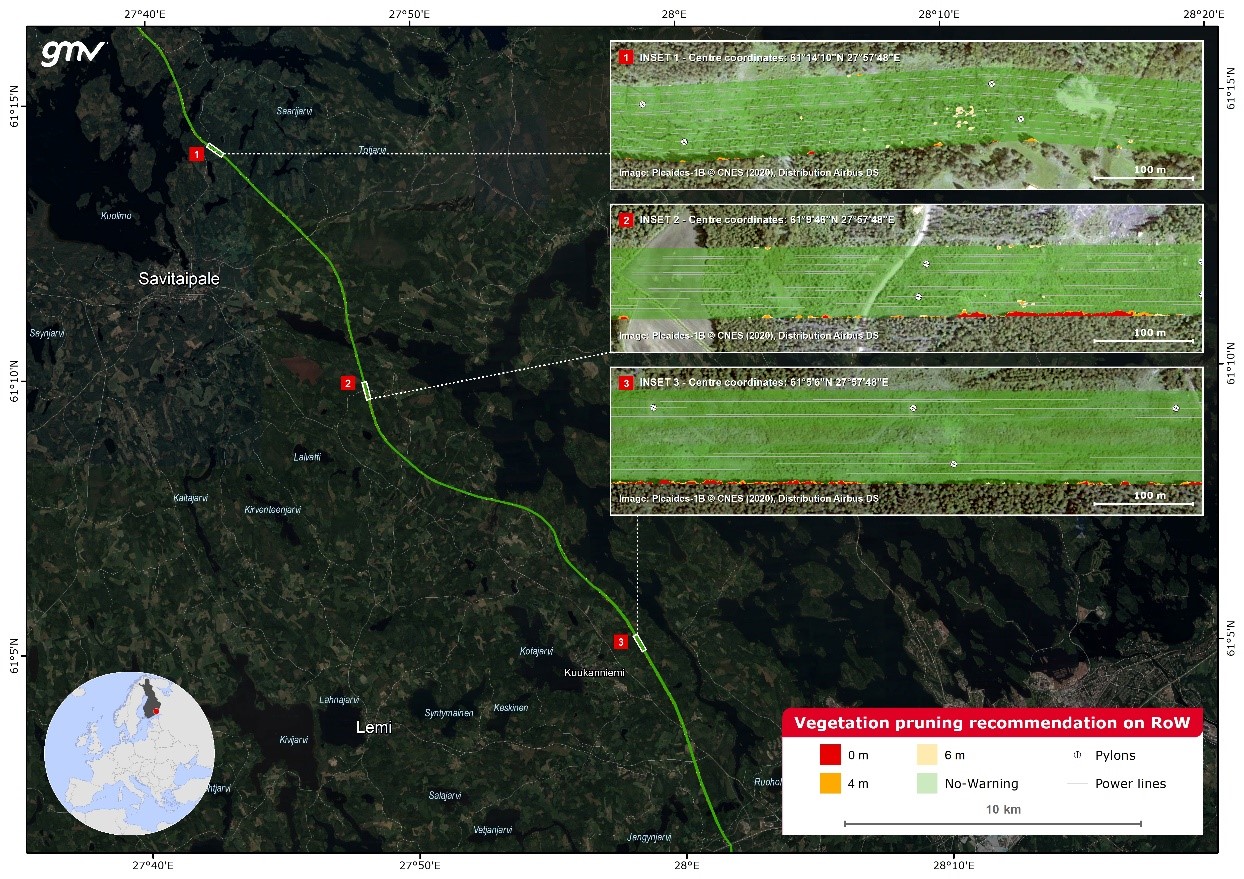
2. Vegetation Pruning Recommendation for ROW: the thematic map in the image below shows the distance between the top of vegetation and the conductors, by classifying it into several categories, based on the vegetation management practices of each TSO (base map © Google Maps).
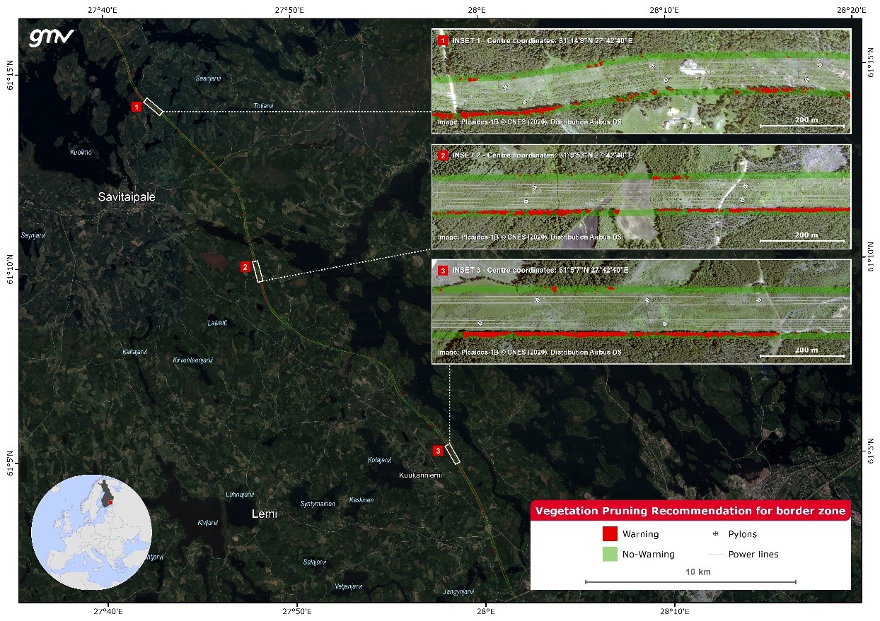
3. Vegetation Pruning Recommendation for border zone areas: this binary map (see figure below) identifies the vegetation exceeding a height threshold set by the TSO ("Warning" class; base map © Google Maps)
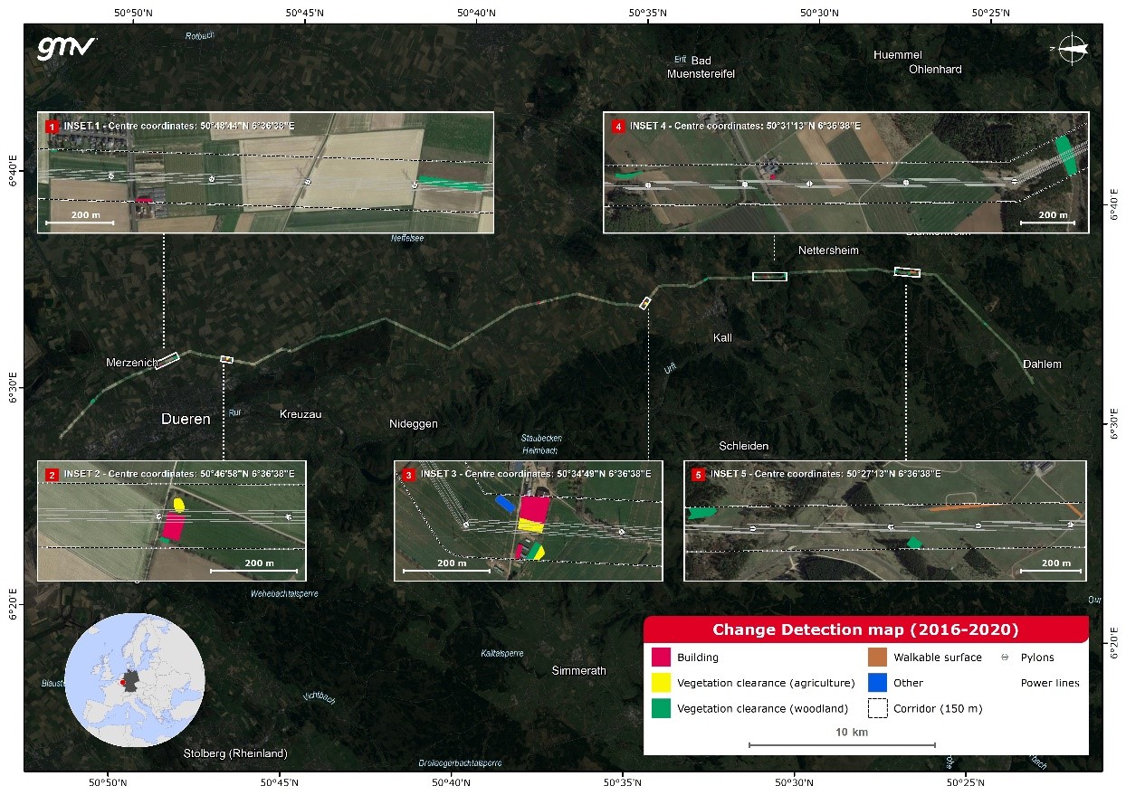
The Change Detection map is the main product of the Change Detection service: this thematic vector map identifies unnatural changes that occurred between T0 and T1 within the ROW. Changes are then classified into several categories, such as construction sites, buildings, roads, etc. The following figure provides an example of the changes detected while running one of the pilots in Germany (base map © Google Maps).
The Disaster Management service entails an urgent preliminary analysis to identify and assess damages over a given location in response to a user’s request, triggered by a disaster event. The Annotated cartographic disaster image product comprises the information extracted from the analysis of satellite imagery (vectors and annotations), supported by a descriptive text on the type and scale of the damage.
It is worth highlighting that the products can be fine-tuned to match customers’ work practices, like the width of the ROW, height thresholds, change detection classes, and so on.
Current Status
The project was the demonstration phase of a previous ESA feasibility study and kicked off at the beginning of February 2022.
Thanks to the project activities and the collaboration with the users, GMV enriched its service portfolio with three new services that aim to support stakeholders in monitoring and managing linear infrastructures. Five pilots in different European locations were run during the demonstration phase, yielding promising results and positive feedback from the involved TSOs. The pilot phase concluded positively with a Final Meeting with all TSOs in June 2023.
GMV will start the rollout of the services by preparing marketing material and having follow-ups with TSOs.
Prime Contractor(s)