

Objectives of the service
Spatialise empowers stakeholders to make data driven decisions for sustainable land use and soil health, reducing soil depletion and supporting resilient ecosystems.

Spatialise provides transformative insights to measure, monitor, and optimize soil health, addressing the critical challenges of modern agriculture. With an increasing global population, farmers are faced with the challenge to enhance yields and mitigate the environmental impact of unsustainable practices, which degrade soil quality, reduce biodiversity, and threaten food security.
A sustainable future for agriculture depends on tools and insights that enable regenerative practices and efficient land management. Key to this transformation is monitoring critical soil properties, including Soil Organic Carbon (SOC), pH, Nitrogen (N), Phosphorus (P), Potassium (K), and Bulk Density (BD). These metrics are essential for assessing soil fertility, water retention, carbon sequestration potential, and overall soil biodiversity. Additionally, precise data on these properties supports optimized fertilizer application, reducing inputs, minimizing environmental harm, and improving yields.

Traditional measurement methods rely on physical soil sampling, which is costly, time-intensive, and often impractical in remote areas. Furthermore, soil samples only provide point specific data. Spatialise overcomes these barriers with an innovative, turnkey solution that leverages satellite data and advanced machine learning to remotely and accurately measure these essential soil properties. This service provides a comprehensive view of soil health and tracks changes over time, delivering outputs as tonnes of CO₂ equivalent (CO₂eq) per hectare and actionable insights into pH, N, P, K, and BD. By achieving ≥80% accuracy, reducing costs by up to 90%, and delivering near real-time results, Spatialise enables data-driven interventions that enhance productivity and sustainability.
Users and their needs
Spatialise serves diverse groups across agriculture, sustainability, and the food sector, tackling challenges in soil health, sustainability management, and Monitoring, Reporting, and Verification (MRV). The key customer segments include:
-
AgTech Platforms, Food and Fashion companies, and Traders: for Supply Chain Resilience
-
Integration of soil health data (e.g., Soil Organic Carbon, pH, Nitrogen, Phosphorus, Potassium, Bulk Density) into field, crop, and practice management tools.
-
Support for crop sourcing decisions and precision agriculture machinery platforms, including variable-rate application and farm management solutions.
-
Compliance with sustainability standards like Corporate Sustainability Reporting Directive (CSRD) reporting.
-
-
Ecosystem Service Providers / Project Developers: for Risk Management & Financial Return
-
Soil as an asset for monitoring, reporting, and verification to achieve corporate carbon and sustainability goals.
-
MRV for carbon credit initiatives and sustainable business models for soil sampling organizations.
-
Soil health predictions as asset evaluation and asset portfolio performance.
-
-
Governments and NGOs: for Monitoring & Evaluation of Impact
-
Selection, monitoring, and evaluation of regenerative agriculture initiatives to drive policy development, assess progress, and determine remuneration.
-
By addressing these needs, Spatialise empowers stakeholders with actionable data, insights and tools to advance sustainability and improve agricultural practices across diverse sectors.
Service/ system concept

Spatialise provides a focused solution for monitoring and analyzing essential soil properties. Our platform offers cutting-edge capabilities through three core services:
-
Interactive Dashboard: Easily visualize and analyze data with our user-friendly interface.
-
Customizable Data Integration: Access raw data and insights seamlessly via our API.
-
Comprehensive Reporting: Receive tailored, standardized reports to meet your specific needs. What makes Spatialise stand out:
-
Global coverage: soil property data at a detailed 10-meter resolution, with over 80% accuracy, backed by robust accuracy metrics and regulatory documentation.
-
Enhanced Accuracy: optimised soil sampling strategies and calibration ensure reliable results.
-
Field-Specific Insights: obtain granular data for individual fields, anywhere in the world.
-
Proven Reliability: developed with peer-reviewed methodologies and trusted by industry leaders.
At its core, Spatialise combines machine learning and Earth Observation (EO) data to deliver scalable, precise soil property models. By integrating ground-truth sampling with satellite-derived predictors, our platform enables soil property estimates tailored for diverse landscapes. These soil property reports include baseline metrics, prediction accuracy, and required compliance documentation, supporting effective carbon accounting and sustainable land management.
The only thing we need from you is your project data, such as field locations and soil samples, to unlock actionable insights. From there, our platform handles everything—data processing, modeling, and generating insights—so you can focus on making informed decisions.
With Spatialise, you gain a science-backed, robust solution that builds confidence in your decisions, empowering effective carbon management globally.
Space Added Value
Spatialise leverages advanced satellite technology to transform the monitoring of critical soil health indicators, including soil organic carbon (SOC), nitrogen (N), phosphorus (P), potassium (K), pH, and bulk density (BD). By integrating in situ soil samples with satellite-derived environmental covariates, our platform provides a detailed and accurate understanding of soil health dynamics. Utilizing 120 variables derived from high-resolution multispectral Earth Observation (EO) data—such as Sentinel-1, Sentinel-2, Landsat-8, MODIS, and others— Spatialise captures spatial and temporal variations in these key soil properties with exceptional precision.
This innovative approach significantly reduces monitoring costs and minimizes reliance on extensive soil sampling, enabling scalable deployment globally. Spatialise data for SOC and its extended capabilities for NPK, pH, and BD monitoring deliver frequent, reliable, and actionable insights. Built on the robust Google Cloud Platform, Spatialise models provide precise predictions tailored to specific years, regions, and soil depths.
By leveraging a wide array of satellite assets, Spatialise delivers a cost-effective, reliable, and scalable solution, redefining traditional soil health monitoring methods and advancing sustainable land management practices.
Current Status

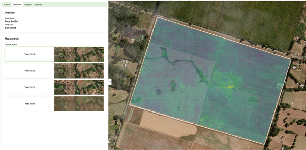
Spatialise has successfully completed the SOCMo 4 RegAg demonstration project. As an outcome of the project, a commercial soil-health monitoring service has been developed, tested, and demonstrated with users in real agricultural environments. For instance, complete Dutch provinces in preparation of the EU Soil Health Law. The service provides (in-)field-level and variation estimates of Soil Organic Carbon, tests with extended soil properties, and related indicators to support regenerative agriculture, carbon programmes, and agribusiness operations.
Prime Contractor(s)
