
Objectives of the service
The main objectives of the services consist in decision support services based on Satellite Communications, Earth Observation data and other space assets to support smart grids management and electricity grid maintenance.
In particular, the system aims to answer the following general goals:
1. Grid reliability and stability
2. Grid optimized used of energy mix (renewable energies, EV, batteries) taking into account different and new opportunities (prosumers and/or aggregators new business opportunities)
3. Grid O&M optimization
4. Assessment of final customers electrical consumption
5. Back-up network systems to allow secure and reliable inter-TSO/RSC (Regional Security Coordinator) data exchange.
Users and their needs
The services address the following stakeholders:
Distributor System Operators (DSO):
The services involve better smart-grid monitoring and management, optimizing together the several elements of the energy-mix such as renewable-plants, e-vehicles and charging stations, storage, consumption.
Additionally, the services involve better grid electricity infrastructure monitoring and management, supporting O&M activities.
Transmission System Operators (TSO):
The services involve better grid electricity infrastructure monitoring and management, supporting O&M, and secure and reliable data exchange and communication capabilities.
Through ESA’s support, the following entities are involved in the project:
- ENTSO-E, the European Network of TSOs, representing 43 TSOs.
- Enel Global Infrastructure and Networks S.r.l (Enel Group), a multi-national power utility, with a presence in 37 countries.
User needs
- Ensure grid stability
- Ensure secure grid
- Ensure power lines infrastructure stability
- Monitor Electric Consumption to detect non-technical losses
- Ensure backup O&M communication and data exchange
- Optimize ticketing services
Related operational challenges
- Manage different grid elements to optimize grid behavior
- Manage impact of new energy ecosystem elements (ex: e-vehicles, storage, charging stations, demand and response capabilities)
- Minimize vegetation-related-risks
- Minimize ice-related risks and costs
- Minimize lightning-related risks and costs
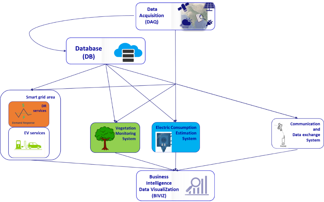
- Electric Consumption Estimation
- Communication backup
- Optimize planning of inspections’ activities, reducing costs; archiving outcomes and lesson learned
The targeted users are European area based, with multinational companies involved.
Service/ system concept
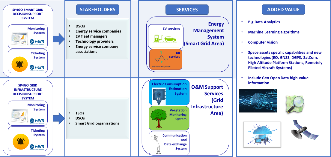
Two solutions are envisaged for the specific needs in the two areas: a Smart Grid Decision Support System (DSS) and a Grid Infrastructure Decision Support System (DSS). Each DSS is furtherly broken down into two main components, one focused on the monitoring and managing (what is currently happening), and one focus on the ticketing (what to plan for the future), as reported in the picture: it shows a recap of main input, outputs and users and added value of the services envisaged.
The services can be distinguished by their goal:
- Grid energy management optimization (demand/response, e-mobility)
- Vegetation monitoring
- Electric consumption monitoring
- Satellite backup platform for data and communication exchange
Space Added Value
The following space assets and technologies are envisaged for the integration in the targeted services:
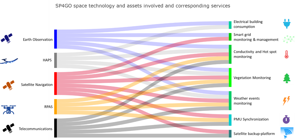
Data from Earth Observation satellites are used in the services as a remote and reliable source of data: archive data are used for energy assessments; quasi real-time data are used for monitoring and for forecasting as a necessary data-inputs.
Telecommunications satellites are used for the specific needs of creating a satellite backup platform for communication and data exchange of O&M operators. The satellite trunk involved in the creation of the backup platform also includes the ground station (gateway and hub) and the VSAT terminal.
Satellite navigation data are used to pinpoint the geolocation of O&M crew operators mobile-phone users, and for geo-positioning RPAS and HAPS acquired data when high-resolution data are needed, and for the calculation of the geo-position of the lightnings.
Current Status
The consortium successfully completed the study proving the commercial and technical feasibility of the proposed solutions. The consortium has conducted several rounds of interviews with different users and stakeholders including companies outside the initial list of entities involved who have shown interest in the services, especially in the vegetation monitoring and in the services related to the smart grid. Mock-ups have been created to help promote the services with prospective stakeholders. Currently, the focus is on preparing a proposal for a demonstration project based on the findings and lesson learned and on developing a partnership with those who have an interest in participating in the pilot itself