Objectives of the service
STEMBOT offers the following services to owners of tree nurseries, orchards and vineyards:
Tree nurseries
Automated stock assessment through tree trunk diameter measurements at one meter height allows for automated size categorisation of each individual tree. With each measurement, a geotag is included, which facilitates easy localisation of the specific tree on the parcel. Additionally, the physical condition of each tree is captured in several images including one image of the roots, one image of the trunk and one image of the canopy. Automated stock assessments reduce the measurement time per hectare greatly and allow the workers to focus on less repetitive jobs. Accurate and reliable sizing of the tree inventory allows nurseries to set an exact pricing of their product and reduces profit loss due to wrong measurements.
Vineyards
Plant-specific mildew detection and treatment to reduce the use of fungicides on vines. This method enables spraying in vineyards only when the disease is just starting to emerge and when plants are not yet suffering from it. Geotagging of the infected plants provide localisation data for treatment. Compared with preventive spraying, this service reduces the cost of fungicides by up to half while improving environmental conditions.
Orchards
Plant-specific disease detection and treatment to decrease the cost of pesticides while improving environmental conditions. Additionally, the robot service also helps to count flowers in spring which gives valuable insights towards yield estimation. Consequently, fertilising, harvesting and logistics can be planned better in advance.
The measurement data retrieved in each sector is visualised in a mobile/desktop application interface. Additionally, the ground data can be aggregated with earth observation satellite data and provide further field insights such as drought and disease mapping. Next to the graphical representation of the collected data, the application can be integrated with a business’ Enterprise Resource Planning (ERP) software to store, manage and interpret the data across the various departments.
Users and their needs
The service focuses on tree nurseries, vineyards and orchards in Belgium and the neighbouring countries France and The Netherlands.
Tree nurseries
Measurement campaigns carried annually in tree nurseries are time-consuming and create a lot of stress just before the start of the sales season through autumn and winter. Tree nurseries would benefit from automated measurements of tree trunk diameters, geotagging the measurements and automated image capturing of the physical appearance of each individual tree.
Vineyards
Viticulture is one of the largest consumers of agricultural chemicals per surface since the risk of an economical loss is generally very large in vineyards. Nonetheless, the content of copper in the soils (which decreases the yield and fruit quality) becomes critical and, through European directives, the sector has committed to get rid of pesticides by 2035. To reach this goal one of the needs is a detection and localisation method for emerging diseases on vines. Such measurements facilitate individual plant treatment with precision spraying systems or UV treatment systems.
Orchards
Orchards are facing real challenges to make their businesses economically sustainable. The price of the fruits is determined at an international level and it is generally difficult for the farmer to remain competitive. Orchard farmers need to save cost by reducing fertilizers and pesticides and optimise harvesting operations. To achieve this, a detection and localisation method for emerging diseases and a measurement system for counting flowers in spring is desired.
Service/ system concept
STEMBOT provides a robotic service to tree nurseries, vineyards and orchards using lightweight versatile robots and satellite data to perform different tasks autonomously including:
-
Monitoring growth progress
-
Measuring essential plant parameters such as fruit counts, drought levels, tree trunk diameters and nitrogen levels
-
Detecting diseases and fungi
-
Carrying payloads, such as UV treatment and variable rate spraying systems, autonomously to reduce manual labour
In tree nurseries, the service offers automation of the yearly stock assessment. In this service, tree trunk diameters are measured at one metre height from the ground and automatically categorized per size. Location data of each measured tree is included. Diameter measurement accuracy is 2 mm, which is well below the range in classes (e.g., 8/10 cm class), and the location accuracy of each tree is within 0,5 metre. Additionally, the physical condition of each tree is captured in several images including one image of the roots, one image of the trunk and one image of the canopy. The service is on-demand (usually one or two stock inventories per season) and scalable to different operation sizes ranging from small tree nurseries of 10 ha up to large 100+ ha operations. Depending on the terrain of the parcels, the speed of measurement is around 0,5 hectare per hour.
In orchards, the service offers plant-specific disease detection. If desired by the customer, a variable rate spraying system implemented on the robot platform, can immediately treat the infected trees. The robot service also helps to count flowers in spring which gives valuable insights towards yield estimation. Consequently, harvesting labour and logistics can be planned better in advance. The service is on-demand and scalable to different operation sizes ranging from small orchards of 10 ha up to large 100+ ha operations. Depending on the terrain of the parcels, the speed of measurement is around 0,5 hectare per hour.
In vineyards, our service offers plant-specific mildew detection. If desired by the customer, a UV treatment system and/or a precision spraying system implemented on the robot platform, can immediately treat the infected vines. The service is on-demand and scalable to different operation sizes ranging from small vineyards of 10 ha up to large 100+ ha operations. Depending on the terrain of the parcels, the speed of measurement is around 0,5 hectare per hour.
Tree nurseries, orchards and vineyards are challenging environments, which also explains why the mechanization has not reached the same level as in other agricultural sectors such as large crops cultivation. Challenges in tree nurseries include reduced GPS accuracy because of the canopy covering. Parcels are split by roads and buildings and are often uneven and muddy. Obstacles such as tree branches and fallen trees occur frequently. Orchards are usually located on flat terrain on which the soil is covered by cover crops such as grass. Vineyards on the other hand are usually located on slopes with a dry, rocky terrain.
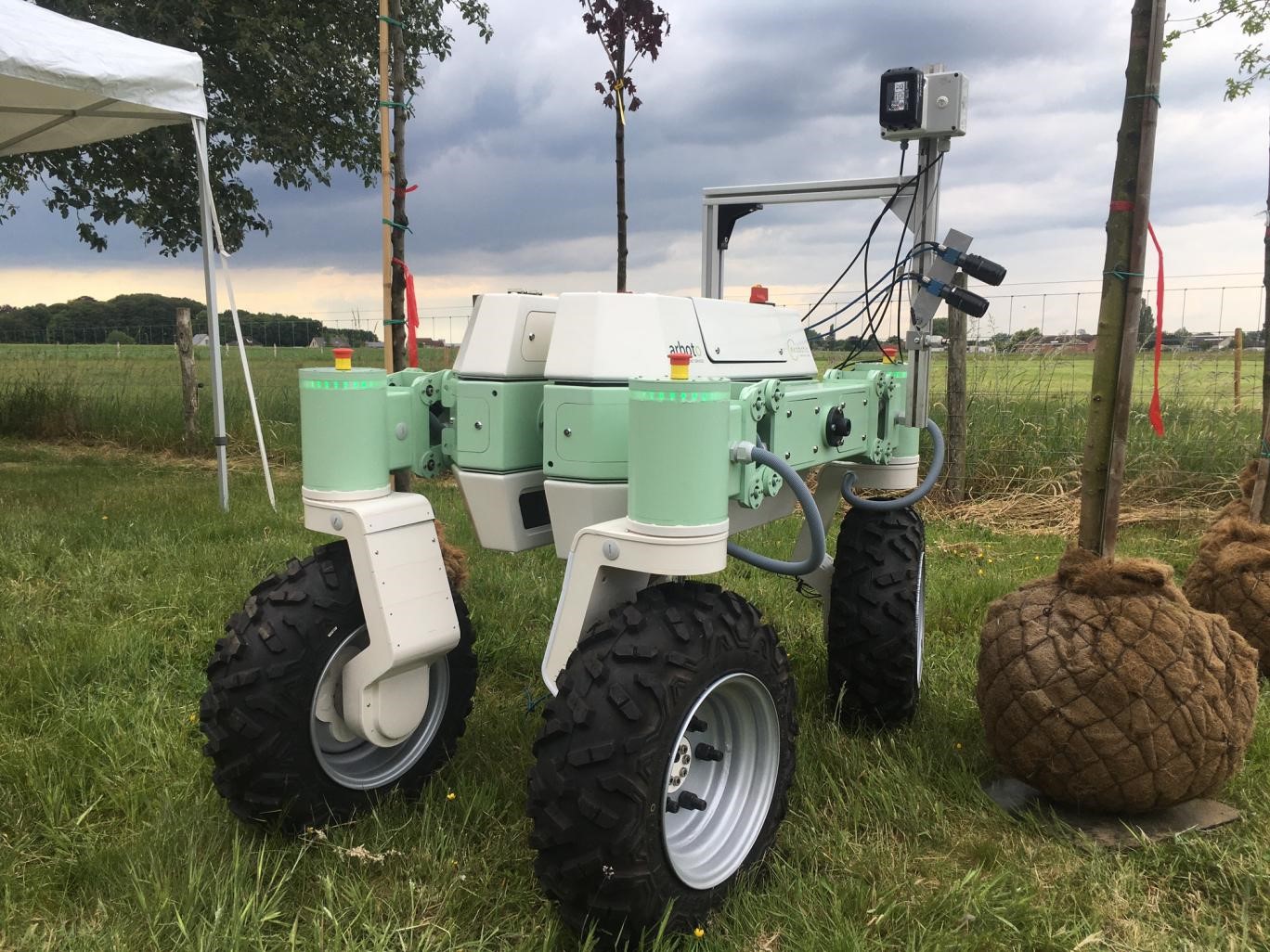
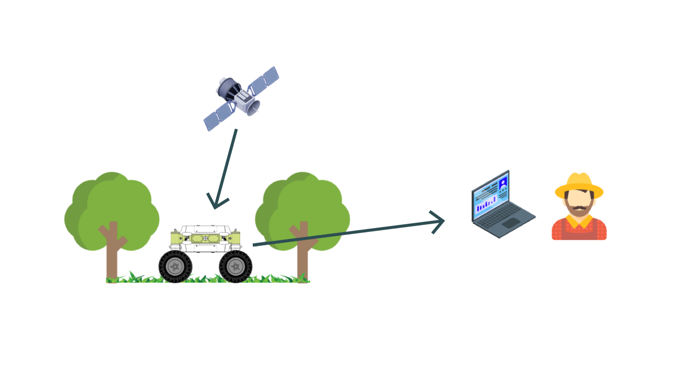
To fulfil the purposes of the service, a ground robot is an important actor in the system. It allows for precise measurements on the ground, such as tree trunk diameter measurements, drought level mapping, fruit counts and disease detection. In order for the robot to work autonomously and safely on rough terrains, challenging specifications have to be met, including obstacle detection, platform stabilisation and the ability to navigate in sub-canopy environments where GPS-signals are often quite weak.
Individual plant parameters should be localised precisely on a map for a coordinated action. Plant-specific monitoring requires a high accuracy in the positioning system. GNSS (Global Navigation Satellite System) satellites allow for precise geotagging of the measurements.
All the information is gathered and presented to the user via a single software platform where farmers can monitor all the results and history of their own field. A desktop/mobile interface and connection with ERP software is a crucial element to provide data qualitatively and ergonomically to the farmers.
Space Added Value
Currently, pesticides and other chemicals are applied homogeneously on a field or parcel level. To scale down these treatments to a plant level and allow a reduction of chemicals, different plant parameters must be identified and localized precisely on a map for a coordinated action, which requires a high accuracy for geolocation. Thanks to Galileo and other constellations, an accuracy close to one centimetre can be reached in open field. In bushy environments this accuracy cannot be achieved. However, relying on multi-constellations Global Navigation Satellite Systems (GNSS) and Real-Time Kinematics (RTK) corrections enable working at a plant level rather than at a row level.
Exobotic Technologies also evaluated if some of the most challenging monitoring tasks encountered in orchards, tree nurseries, and vineyards, namely the prediction of tree diameters, could be achieved from satellite images. With commercial satellites like WorldView-3 providing high resolution images up to 30 centimeter per pixel in panchromatic, it was evaluated if the most challenging monitoring tasks encountered in orchards, tree nurseries and vineyards could be achieved from satellite images, which is to predict tree trunk diameters. However, it was shown that prediction of tree trunk diameters from satellite imagery is not technically feasible at the moment.
Current Status
A robot and monitoring algorithms to compare the performances of ground and satellite data for horticulture monitoring tasks were developed. Using different vision sensors and techniques of Machine Learning, the ground system showed that it can determine plant-specific parameters, such as tree trunk diameters, with an accuracy close to manual measurements. Using multi-constellations Global Navigation Satellite Systems (GNSS), Real-Time Kinematics (RTK) corrections and unsupervised machine learning algorithms, it can cluster the measurements and assign them to a plant.
Our main nursery partners in this project show great interest in the automation and accuracy of the measurement system for tree trunk diameters. Especially the speed of measurement is a great advantage. The cost per hectare for measurements might still be too high for some farmers to consider switching to our measurement system. Most farmers would agree to a price of 200 €/ha. There were also doubts about the geotagging functionality in the context of harvesting. Feedback from the farmers indicate that they prefer a visual in-field method of tagging the trees. With this method, a harvesting team can then quickly observe where trees of a specific diameter are located in the parcel. The robot platform was perceived as ‘trustworthy’ and ‘safe’ to navigate through the rows and on the uneven terrain without hitting trees or other obstacles.
Exobotic Technologies plans to carry out an end-to-end in-field demonstration of this service to obtain more feedback about the operational service from the farmers.