
Objectives of the service
The services combine snow, weather and ground movement from various sources, such as automatic weather stations, weather forecast, satellite data and GNSS technology. We provide insights into hazards, risks and monitoring related to avalanche activity, snow, and ground movements by integrating data, hardware, software, and multidisciplinary expertise. The system uses data from the EU Copernicus programme, particularly SENTINEL-1 Synthetic Aperture Radar (SAR), to deliver three essential services.
Authorities responsible for avalanche risk management face significant challenges due to reliance on manual observations, high operational costs of traditional monitoring systems, and limited spatial coverage—especially in remote or mountainous areas. Historical avalanche records are often incomplete or unavailable, and high-resolution large-scale avalanche inventories are rarely accessible.
Due to climate change, knowledge of snow water equivalent reserves is becoming increasingly important, and the maps/data currently available are outdated and inaccurate. Additionally, monitoring snow-related ground movements is lacking, particularly in mountainous or isolated regions.
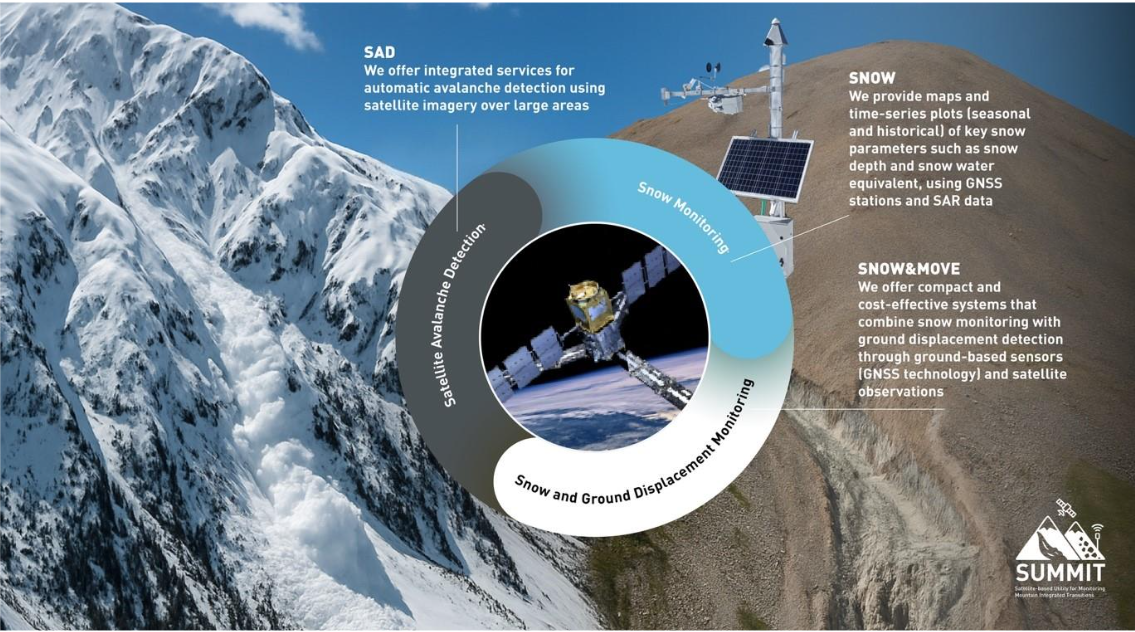
The SAD service provides an automated avalanche activity detection over large areas, the main goal is to improve forecasting accuracy, reduce manual workload and allow near-real time and historical avalanche activity reconstruction.
The SNOW solution provides high-resolution maps and timeseries of key snow parameters, including snow water equivalent, snow depth and wet snow conditions, integrating satellite data, GNSS technology, automatic weather stations, and weather forecasts to ensure high spatial resolution, high data frequency, and improved accuracy.
SNOW&MOVE is a compact and cost-efficient solution that combines snow monitoring with ground displacement detection based on GNSS sensors and satellite InSAR observations. The system integrates snowpack and ground movement monitoring, even in remote areas, supporting risk assessment and infrastructure planning. This combined approach increases data quality, lowers operational costs, and simplifies management by unifying snow and terrain monitoring under a single system.
Users and their needs
The user community involves:
National and international avalanche forecasters, public agency (mainly in Italy), private avalanche monitoring companies (in Europe), ski resorts (mainly in the Alps), construction companies in remote avalanche-prone areas (EU and beyond), hydropower and water supply companies (mainly in Italy), hydrogeological monitoring agencies/utilities (Italy and Europe), and spatial data service companies.
-
Avalanche forecast validation:
improve local forecasts using post-event data; challenge: >80% reliability vs. manual observations.
-
Avalanche monitoring in remote areas:
characterize activity for infrastructure design; challenge: limited data, manual verification needed.
-
Identify active release zones:
optimize artificial triggering system placement, saving time and cost; challenge: simulations lack precision.
-
Automated avalanche database management:
update registries for hazard mapping; challenge: maintain data reliability.
-
Snow maps for water resource management:
high-res maps and timeseries data for hydropower and water supply; challenge: validation via observations and simulations.
-
Wet snow condition for wet avalanche danger prediction:
high-res maps and timeseries data for public agency to improve wet snow avalanche forecasting.
-
Snowmaking management for ski resorts:
detailed maps to optimize snowmaking; challenge: comparison with other systems.
-
Monitor snow-influenced landslides:
forecast landslide acceleration due to snow changes; challenge: integrate snow and ground data.
-
Monitor snow and ground in remote areas:
detect snow and movements in poorly monitored zones; challenge: field and simulation validation.
Service/ system concept
The information provided varies depending on the service and user type. The main option is a dashboard displaying avalanche activity analysis results on a map, along with measured or simulated snow and weather parameters and ground displacements. These outputs can be shown both as point values and spatial layers on interactive maps. Alternatively, users can access raw data via API services for integration into their own platforms.
The system allows users such as forecasters, public authorities, ski resorts and private companies to monitor, analyse and plan based on avalanche events, snow and ground displacement information.
At a high level, the architecture consists of three main components: (1) data collection from satellites, sensors, and models; (2) data processing and analysis using cloud infrastructure; (3) user access via dashboard or API.
The goal is to deliver accurate, up-to-date, and easy-to-interpret information that supports decision-making in risk management, infrastructure planning, and resource management.
The system includes a computational backend that processes satellite, GNSS and snow-weather station data. It stores results via web services in databases, manages access through authentication, job schedulers and APIs, and delivers clean, ready-to-use outputs to the user interface.
Space Added Value
The project uses several space assets: Copernicus Sentinel-1 and Sentinel-2, COSMO-SkyMed and Galileo. These are key to enabling near-real-time monitoring and historical reconstruction of avalanche activity and spatialize snow/ground movements.
For satellite avalanche detection (SAD), Sentinel-1 SAR images are used to detect changes in backscatter and emissivity, identifying avalanche paths via pre/post-event comparisons and RGB composites. SAR-polarimetry enhances detection capabilities.
For snow and ground monitoring (SNOW/SNOW&MOVE), cost-effective, multi-frequency GNSS stations (tracking Galileo and GPS) provide precise point measurements of snow parameters and ground movement. These are integrated with data coming from automatic weather data, weather forecast, SAR data from Sentinel and COSMO and to improve spatial coverage and accuracy. Sentinel-2 optical data are used to map snow extent, detect surface features, estimate SWE and identify protective forest areas.
The combined use of SAR, optical, GNSS data and corner reflector observations allows for higher accuracy, broader coverage and lower cost than traditional ground-based systems, giving a significant competitive advantage over existing methods relying only on field sensors or non-integrated data sources.
Current Status
The project successfully passed the Design Review phase at the end of February 2026 and is currently in the stages of development/validation, in preparation for the Acceptance Test scheduled for September and for making the services operational ahead of the next winter season (2026–2027).

