Objectives of the service
The SUPER feasibility study investigated two potential services to Urban Air Mobility (UAM) stakeholders that are based on a same concept, 3D-MUP (3D-Mapping for UAM Planning). 3D-MUP allows aggregating various data sources, including Satellite Earth Observation (SatEO) and Satellite Navigation (SatNav), in UAM infrastructure planning, to support the integration of UAM services into public transport and the planning and monitoring of UAM operations. These two services are:
-
UAM Strategic Planning Service: introduces 3D urban zoning to facilitate aerial vehicles integration with other public transport means and support planning of the vertiports and their network;
-
UAM Operations Support Service: supports the identification of new obstacles, adverse weather areas and possible route planning or linking different existing vertiports.
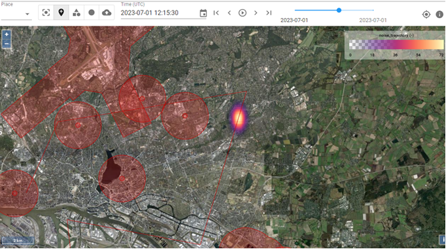
The services can be accessed through a Geographic Information System (GIS) that allows end-users to add layers of information to a map of an area of interest (i.e. a city or its surroundings).
Users and their needs
The primary users of the 1st service are city council or local authorities, as well as infrastructure providers, that need a tool for the strategic planning of UAM infrastructure and to facilitate aerial vehicles integration with other public transport means. In details, they need:
-
Information about current and planned transportation infrastructure (roads, airports, trains, local transportation);
-
Information about landscape and land use patterns in the urban and exurban area
-
Socio-economic information on the area;
-
Projections on how the population will develop;
-
The combination of the above in order to plan vertiport locations, air corridors, access to air corridors and thus to define three-dimensional air-route plans.
The 2nd service is intended for infrastructure or aerial vehicle operators that need a way to plan and monitor their own transport services through the identification of new obstacles, adverse weather and possible route planning or linking different existing vertiports, through information such as:
-
VHR EO data with various time horizons, to support flight planning from strategic planning of routes several weeks or months in advance to individual flight planning with recent information;
-
Micro-weather forecast (urban wind and weather effects) for safe and cost-effective high-density operations.
-
To demonstrate the conformance of their operations with noise emission requirements or flight restrictions.
-
To optimise flight routes.
Service/ system concept
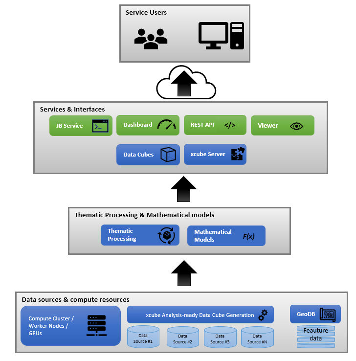
Solutions to find, access, and harmonise heterogeneous data from distributed sources are readily available but may need extensions to include novel data sources. Likewise, there are different options for visualisation, analysis, and processing of information as well report generation and interfacing to end-user environments. While dedicated applications like xcube viewer may offer substantial tailoring and a seamless integration with its versatile back-end xcube server, a full-fledged GIS would excel with its extensive functionalities, which may even be further extended by plugins. For some approving authorities, the usage of a specific, own system may be mandatory, in which case the integration of additional data would be the main task. Moreover, expert users may benefit from the access to an interactive processing environment like a pre-configured Jupyter Hub to leverage Python’s data science ecosystem for the development and execution of complex analysis and processing workflows.

Space Added Value
UAM will benefit in two ways from satellite-based information (at least). First, the aim of introducing SatEO (archived and near real-time data) is to provide diverse geospatial, environmental, weather and mapping information used for improved planning of infrastructure and flight corridors, and second the combined use of environmental information from SatEO with positional data from SatNAV technologies provides fast communication means and allowing frequent observation of critical urban and intra-urban areas.
Integration of space data, data from drones and other background data, with numerical models for nowcasting and forecasting, and applying AI methods to extract information improves both, planning and operations, leading to smarter use of urban infrastructure and reducing congestion. It will lead to better traffic management as well as fulfilling stringent requirements to ensure safety in urban areas.
For both services proposed in SUPER, relying on satellite data services provides users with a constant and up-to-date stream of information, that current technologies such as online mapping tools or aerial photography do not offer.
Current Status

SUPER has consulted about 50 representatives from various stakeholder groups across Europe, including city authorities, competitiveness clusters, eVTOL manufacturers, vertiport developers, aviation institutions and air navigation service providers. The objective was to present them the services under assessment, understand their potential interest in these services and identify their requirements and constraints.
This led to the definition of the services and of the underlying systems required to connect with EO and SatNav data sources, aggregate them in a data cube and allow end-users to interact with the data overlaid on maps. This task was supported by a comparative analysis of available public and commercial EO and SatNav services that could provide the input information required by the services investigated in SUPER.
In parallel with this definition work, the viability of the proposed services was assessed from a financial point of view, but also from a non-financial perspective including political, social, technological and environmental factors.


