Objectives of the service
The aviation sector is gradually supporting GNSS-based landing procedures that can provide high precision positioning at lower costs than ground based infrastructures (such as ILS and GBAS). These procedures are diverse and under certain conditions can offer precision levels matching those of a Category I precision approach. The susceptibility of the GNSS signal to interference originating from various sources, including Space Weather ionosphere perturbations, points toward the need for GNSS monitoring and performance assessment.
The SWAIR service provides early warning, forecast and performance assessment of GNSS signal, at a local level, for the Air Navigation sector. SWAIR aims to increase confidence of air operators in using EGNOS and GNSS signals. It addresses the problem of intentional and unintentional interferences (e.g. jamming) and Space Weather events which can influence the performance and reliability of a variety of positioning systems. SWAIR also assesses the sources of GNSS signal vulnerability in order to develop mitigation activities. The product furthermore addresses the problem of the peripherical boundary of EGNOS (such as the Lisbon airport) and GNSS landing without SBAS coverage (e.g. Azores islands/ Madeira).
Users and their needs
The target users of SWAIR are entities taking advantage of the benefits brought to the aviation sector by GNSS and being directly or indirectly affected by the GNSS signal degradation due to Space Weather and other factors. The users of SWAIR generally represent the following aviation sectors:
-
Air navigation service providers (ANSP);
-
Airports;
-
Civil aviation authorities (CAA);
-
Airlines.
Air navigation service providers are entities responsible for providing air navigation services and managing air traffic at a specific territory or country. Their needs may be summarized as follows:
-
real-time operational monitoring of GNSS signal quality to assist air traffic controllers;
-
real-time alerts about ongoing and predicted GNSS discontinuities of various origins, including Space Weather events;
-
periodic GNSS performance assessment;
-
monitoring of GNSS interference causes.
Airports with independent air traffic control centres need the operational GNSS monitoring and alerting service, to be able to make decisions based on the GNSS signal being up to international quality standards, required for use in approach procedures.
Civil aviation authorities, as statutory authorities in each country that oversee the approval and regulation of civil aviation, need to:
-
oversee the GNSS signal performance and the influence of Space Weather on GNSS navigation in the territory of their influence;
-
have access to reports and statistical data about discontinuities to be able to identify and mitigate potential sources of interference;
-
have access to recorded GNSS data to assist in incident and accident investigations.
Airlines, or more specifically their flight planning and dispatching departments, need to have access to:
-
a GNSS discontinuities alerting service;
-
satellites availability and geometry forecasts;
-
alerts about Space Weather events affecting the GNSS signal.
The existence of the need for Space Weather and GNSS performance monitoring and assessment in the aviation sector is undeniable and well-founded by international recommendations and regulations. The reality, however, has obliged the responsible parties to depend completely on data coming from navigation service providers or national and/or international networks. There has been no local-level monitoring coverage, nor has there been the flexibility oftentimes required, especially for GNSS-based approach procedures.
SWAIR targets aviation entities globally with initial focus on Europe.
Service/ system concept
SWAIR encompasses four main products:
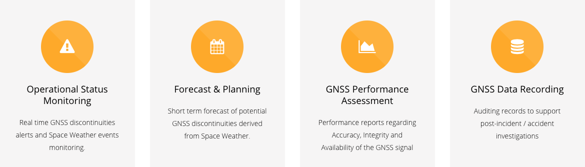
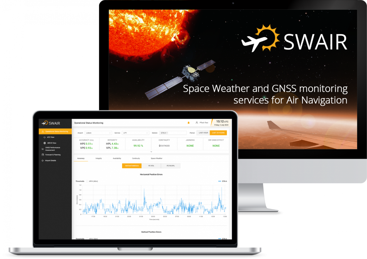
Operational Status Monitoring - this service provides real-time information about GNSS signal quality, delivers real-time alerts when GNSS signal discontinuities occur and monitors Space Weather events.
GNSS Performance Assessment – includes reports on the performance assessment for the GNSS signal, detailing the accuracy, integrity, continuity and availability of the signal for specific time periods.
Forecast & Planning - provides a short-term forecast of potential discontinuities in the GNSS signal due to Space Weather events and predicts satellites visibility.
GNSS Data Recording – raw GNSS data recording compliant with the ICAO regulations to assist in post-incident or accident investigations.
The overall system architecture of SWAIR envisages four main blocks of interaction: users, external data providers, validation data procurement and the SWAIR Platform.
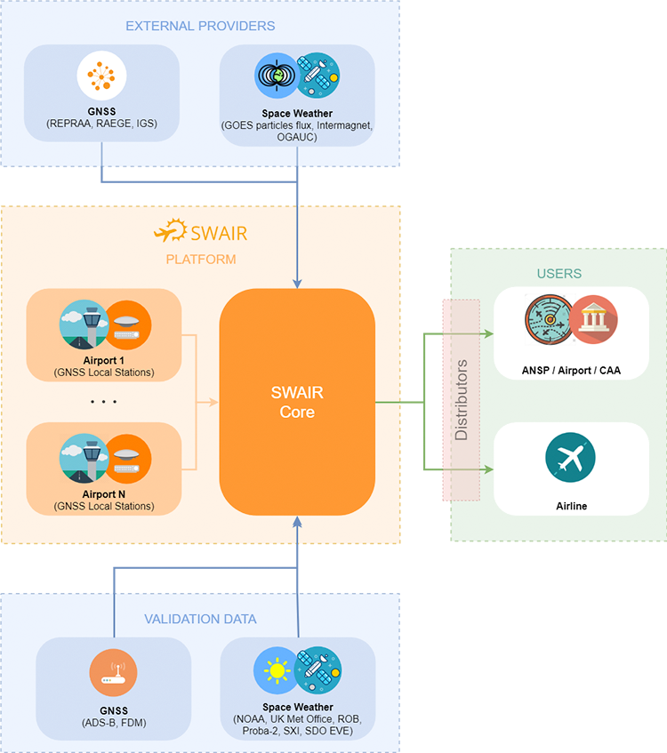
The SWAIR Platform consists of two distinct modules: GNSS monitoring sites and the SWAIR Core. Briefly, the monitoring sites, located primarily at airports, contain GNSS local stations, in charge of GNSS data acquisition. The SWAIR Core is responsible for data collection, validation, processing and the delivery of the SWAIR products to its final users.
Each monitoring site consists of two GNSS stations: primary and secondary.
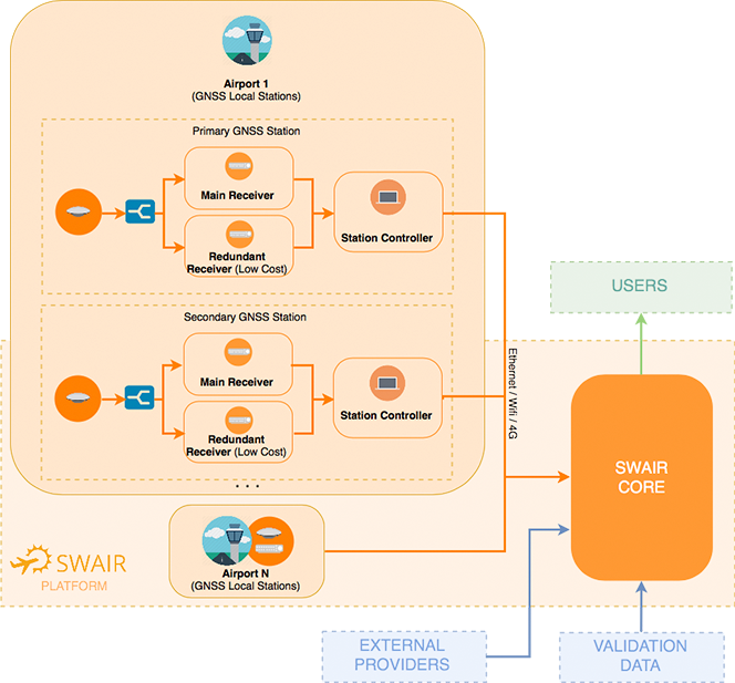
The station redundancy aims at detecting and eliminating potential environment failures on location. The receiver redundancy within each GNSS station, on the other hand, allows for hardware failures detection in the main receiver, and development flexibility to implement new features (such as jamming detection).
Space Added Value
The main Space assets used are:
-
Satellite Navigation: SWAIR’s focus is on the analysis of GNSS signals for aviation, mainly GPS, GLONASS and EGNOS and also considers GALILEO and BEIDOU as potential evolutions. The service stipulates direct use of this space asset and eventually using GNSS data acquired by external providers.
-
Space Science Data, SWAIR uses Sun observation satellites for the detection of sun events, namely Proba-2, Goes Solar data and SDO EVE (Extreme Ultraviolet Variability Experiment). The usage of processed Space Weather data by external providers (e.g. Met Offices) is also considered.
Current Status
Despite the challenging situation of COVID-19 pandemic, that has struck the whole world (affecting in particular the aviation sector) in a critical moment of the project, the pilot started on the 01 January 2021 with a duration of 5 months. The pandemic, associated to the enforcement of a new general confinement in Portugal during most of the pilot duration, had a strong impact on the pilot activities and also on the user’s engagement to proactively accessing the service.
Nevertheless, the project successfully achieved a pre-operational product, considered an essential instrument for the market entry, that is currently available to perform demonstrations whenever needed. During the pilot, the system’s overall reliability and performance was considered very good by the users, as well as the quality of the data produced by the provided service.
The full commercial roll-out will only be performed after the project, taking in consideration that sales are highly dependent on the authorities’ enforcement to monitor GNSS signals, and after aviation reaches capacity and economic levels verified before pandemic.