

Objectives of the service

Climate change is intensifying threats to European forests through droughts, pest outbreaks, wildfires, and storms. These threats create severe environmental impacts but also operational challenges for forest managers and significant financial losses for forest owners through timber devaluation and emergency interventions.
This crisis demands a fundamental shift in forest management—moving from long-term, multi-year planning to continuous, flexible, risk-centered approaches that enable rapid response to emerging threats.
Goodforest addresses this challenge by combining satellite remote sensing and artificial intelligence to provide forest professionals with the tools they need for proactive forest protection. Our platform delivers continuous health monitoring, early detection of dieback, predictive multi-risk assessment and actionable decision support tailored to each forest.
By transforming forest management from reactive crisis response to proactive risk management, Goodforest helps preserve forest health, protect timber value, and maintain forests' critical role in climate mitigation and biodiversity conservation.
Users and their needs
Goodforest targets three key user communities across Europe:
Forest Service Providers (cooperatives, management firms, public agencies)
- Continuous health monitoring: Need to detect and locate forest health issues across large, dispersed territories
- Automated forest inventories: Require up-to-date forest data to replace costly manual inventories
- Post-disaster damage assessment: Need rapid, accurate evaluation of wildfire and windthrow damages
Forest Asset Managers
- Portfolio monitoring: Need centralized, real-time forest health indicators to prevent asset devaluation from undetected deterioration
- Due diligence: Require faster, more accurate forest condition assessments for acquisitions
Forest Insurance Companies
- Claims assessment: Require rapid, accurate post-disaster damage evaluation across large affected areas
Service/ system concept
Goodforest functions as an automated forest scanner, continuously analyzing forests in near real-time, anywhere, detecting issues often before they become visible to the human eye.
System architecture (4 stages):
- Satellite data acquisition: Automatic collection and processing of imagery
- Data enrichment: Integration of contextual data
- AI-powered analysis: Deep learning models process combined data to detect anomalies, assess health status, identify risks, and generate insights
- User applications:
- Web application for planning, analysis, and reporting at the office
- Mobile application for field teams
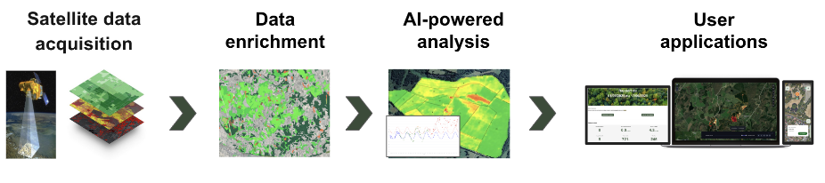
The platform provides forest managers with a complete decision support system.
Space Added Value
Goodforest uses multiple satellite data sources to provide global forest monitoring:
Satellite assets:
- Sentinel-2 multispectral imagery
- Sentinel-1 radar imagery
- Very high-resolution commercial imagery
Added value versus traditional methods:
Traditional forest monitoring relies on periodic field inspections covering only small fractions of managed areas, often detecting problems too late. Existing satellite-based competitors typically use single vegetation indices with limited accuracy.
Current Status
Goodforest currently monitors 15k hectares of forests under active health surveillance across four European countries, working with key industry stakeholders.
Key achievements:
- Automated health monitoring analysis and alert system successfully deployed
- 15,000 hectares of forests currently under continuous surveillance across multiple European countries
- Detection system delivering excellent results on several coniferous species
- Active partnerships with key industry players
