Objectives of the service
Georeferenced, real-time information has become an essential part of any emergency management system. For this reason, it is of central importance how this information is collected, communicated, analysed, and visualized during the preparation and execution of emergency events. Incorrect, delayed, incomplete, and outdated information leads to wrong decisions and can endanger lives.
In close cooperation with rescue and emergency organisations, other public authorities and stakeholders from industry, a concept for a "Test and Trial Centre for Geoinformation- and Satellite-based Services for Authorities and Organisations with Security Responsibilities" was developed, which has been implemented in this demonstrator project.
TT-GSat offers the following services:
-
Scoping: Requirement analysis, market research / analysis, feasibility studies / proof of concept, technical consulting, support of product development
-
Testing: tests of components, products, services in laboratory and outdoor environments, use of the TT-GSat test environment and
-
Operational Support: Temporary provision and / or operation of solutions
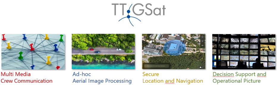
TT-GSat covers the following topic areas:
-
Multimedia communication between operational forces,
-
Ad-hoc aerial image processing,
-
Secure localization & navigation and
-
Situation presentation and decision support.
TT-GSat helps to improve networking between all participating organisations in order to support user-oriented development and enable emergency forces to apply new and innovative satellite-based technologies as quickly as possible.
Users and their needs
TT-GSat is involving different stakeholders, end-user communities and primary end-users in the following categories:
-
Emergency services
-
Fire departments
-
Police authorities
-
Disaster protection
-
Other public authorities and politics
-
Industry and service providers
-
Public and private institutes & innovation / competence centres
Main user requirements:
-
Usage of ad hoc (broadband) communication
-
Interoperability between different components and systems (open standards)
-
Usage of drones (sensors, pictures, videos, transportation)
-
Navigation and localisation (outdoor and indoor)
-
Ad-hoc aerial images (from drones and satellites)
-
Improving operational management and situational awareness through the use of augmented reality and virtual reality glasses
-
Object recognition by means of artificial intelligence (e.g., counting of different types of road users, determination of human densities)
Since the three project partners all come from the federal state of Bavaria in southern Germany, most participating user groups were located in Bavaria, Austria and Northern Italy. However, this is only the beginning: TT-GSat is a Europe-wide project.
Service/ system concept
TT-GSat offers a Test and Trial Centre for Geoinformation- and Satellite-based Services for Authorities and Organisations with Security Responsibilities where it is possible to touch, try out and play with real building blocks in order to creatively find and implement new solutions. TT-GSat provides the following benefits for its users:
-
Manufacturer-neutral technology assessment and testing of innovations
-
Consideration of integrated, holistic approaches instead of partial solutions
-
Carrying out tests and feasibility studies of new technologies before purchase / market entry
-
Assessing the impact of future communication and information requirements
-
Minimising implementation risks of new technologies through cost-effective testing of integrated solutions
-
Find and try out possible technologies to decrease the duration and costs of typical use cases
-
Find and try out possible technologies to increase safety of task forces
-
Increase user friendliness of solutions
-
Creation of an advisory/contact point for authorities and organisations with security tasks
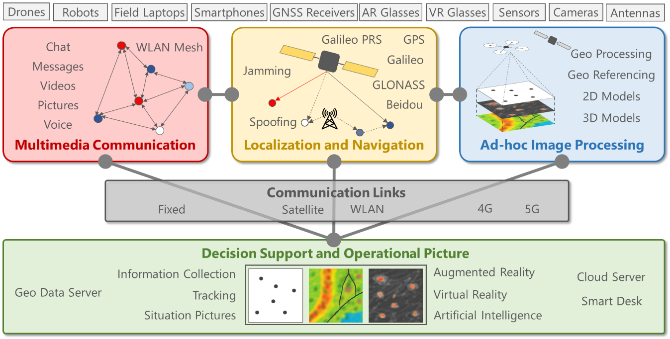
To achieve this, TT-GSat consists of the following building blocks:
-
TT-GSat field components like smartphones, augmented reality glasses, notebooks, tablets, drones, unmanned ground vehicles, video cameras, high resolution earth observation cameras, different types of sensors (like e.g. thermal sensors, acceleration sensors, LIDAR, GNSS receiver), GNSS jammers, GNSS spoofers, GNSS signal generators
-
TT-GSat centre with cloud servers and data storage, GPU capacity designed for artificial intelligence training procedures, virtual reality glasses for the visualisation of 3D situational pictures with two-way communication to the augmented reality glasses, a smart desk for the communication between augmented and virtual reality glasses
-
WAN and LAN communication links (WLAN, fixed IP networks, LTE and 5G mobile radio communication networks, satellite communication networks)
These building blocks can be individually combined with each other in order to try out and test the interaction of different equipment in different deployment scenarios. With the building blocks provided, it is possible to cover the four subject areas envisaged in TT-GSat:
-
Multimedia communication between operational forces
-
Ad-hoc aerial image processing
-
Secure localization & navigation and
-
Decision support and operational picture
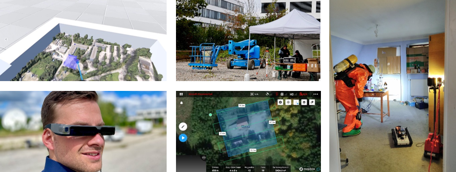
The following use cases were evaluated with selected user groups:
-
Ad-hoc WLAN mesh networks, unmanned ground vehicles with cameras and different types of sensors, field server with data repository
-
Provisioning, processing, and dissemination of up-to-date earth observation information gathered by satellites and/or drones for the preparation and control of planned situation in an operation control centre
-
Demonstration of the advantages of Galileo PRS over commercial GNSS receivers in jamming and spoofing environments
-
Seamless outdoor to indoor navigation with unmanned ground vehicle or smart vest and object detection based on artificial intelligence
-
Use of augmented reality glasses to improve the on-site mission execution of task forces in combination with a 3D situation of the mission area visualization by means of virtual reality glasses in the situation centre
Space Added Value
The Test- and Trial-Centre for Geoinformation- and Satellite-based Rescue & Emergency Services (TT-GSat) utilises three space assets:
-
Satellite communication systems in combination with terrestrial communication systems like professional radio networks, commercial radio networks, terrestrial fibre networks for unreached availability in mission areas where the communication infrastructure is not available, overloaded, or destroyed. What is more, local stand-alone ad-hoc networks can be connected with satellite network systems.
-
Satellite navigation services for secure satellite-based positioning, navigation, tracking and synchronization, for example Galileo Public Regulated Service, Galileo Open Service, GPS.
-
Earth observation services to deliver aerial photographs of high precision and actuality to obtain up-to-date information on the relevant mission or crisis event, its geographical extension, its temporal development, damages, etc.
Current Status
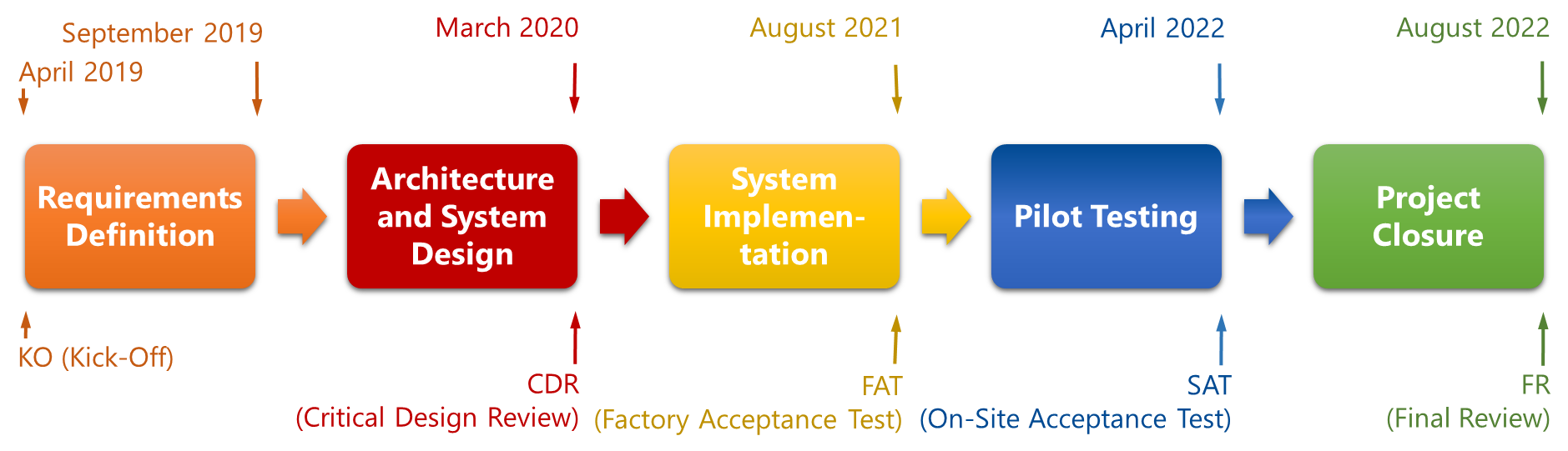
The project has been successfully completed in August 2022, see timeline below.
In July 2022, the project partners concluded a cooperation agreement governing the joint continuation of the ESA demonstrator project TT-GSat after the end of the funding phase by ESA. The project partners expect the following advantages in particular:
-
Offering a broader portfolio to customers under a common name within the existing structure of the TT-GSat demonstrator project
-
Reduction of costs through joint use of resources (personnel and material)
-
Use of synergies (personnel and technical)
Prime Contractor(s)