
Funding Opportunity
The European Space Agency (ESA) invites companies to participate in the Coastal Resilience to Climate Change initiative. This opportunity aims to support the development of innovative services that leverage space technology to address the challenges posed by climate change to coastal cities, rural coastal regions, and ports. The Call for Proposals welcomes submissions for Feasibility Studies and Demonstration Projects. Please refer to the ‘Authorisation of Funding’ section below to determine your team's eligibility for funding.
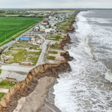
The Challenge
Coastal regions are particularly vulnerable to the effects of climate change, including rising sea levels, severe storms, flooding, and coastal erosion. These changes threaten essential ecosystems and the infrastructure supporting tourism, trade, and fisheries, while also affecting the livelihoods of coastal communities. In Europe alone, over 200 million people reside within 50 kilometres of the coastline, placing them at increased risk of climate-related hazards. These coastal regions play a crucial role in Europe’s economy, contributing to nearly 40% of the continent’s GDP and handling 75% of its international trade via maritime routes
Topics of relevance
Here are some examples of potential services that could be developed under this initiative:
- Monitoring and Early Warning Systems: Monitor environmental changes to provide early warnings for extreme weather events, such as storms, floods, and heatwaves.
- Monitoring Coastal Erosion and Sea-Level Rise: Track coastal erosion and sea-level rise to plan and implement coastal defences.
- Water and Ecosystem Management: Manage water resources by monitoring rainfall patterns, river flows, and drought conditions.
- Biodiversity and Ecosystem Services: Monitor changes in biodiversity and ecosystem services to protect and manage natural habitats.
- Urban and Infrastructure Planning: Use accurate geospatial information to design resilient infrastructure that can withstand climate impacts.
- Adapting Coastal Agriculture: Implement services to protect crops from salinity intrusion, flooding, and extreme weather events.
- Disaster Response and Recovery: Ensure reliable communication during and after disasters for effective coordination of emergency services.
- Nature-Based Solutions (NBS): Implement NBS, such as mangrove restoration, to enhance coastal resilience and provide multiple ecosystem services.
- Port Solutions: Develop management systems for ports to adapt to climate impacts, such as raising quays and installing advanced drainage systems.
- Tourism: Implement climate adaptation strategies to protect tourism infrastructure from rising sea levels, coastal erosion, and extreme weather events.
- Insurance: Use satellite data to assess risks and manage claims, providing financial protection against economic losses from storms, flooding, and erosion.
- Corporate Sustainability Reporting Directive (CSRD): Help companies report physical risks and opportunities related to climate change and outline strategies for resilience.
Value of Space and other technologies
Space-based technologies play a crucial role in enhancing coastal resilience to climate change. By leveraging satellite Earth observation (SatEO), global navigation satellite systems (GNSS), and satellite communications (SatCom), innovative solutions can be developed to address the challenges faced by coastal regions.
- Satellite Earth Observation (SatEO) provides vital data for monitoring environmental changes and supporting climate adaptation strategies. This data is essential for tracking coastal erosion, sea-level rise, and alterations in biodiversity and ecosystem services. SatEO facilitates the development of early warning systems for extreme weather events such as storms, floods, and heatwaves, thereby mitigating their impact on infrastructure and communities. By observing rainfall patterns, river flows, and drought conditions, SatEO data also aids in the management of water resources.
- Global Navigation Satellite Systems (GNSS): GNSS is crucial for the effective coordination and management of resources in the aftermath of a disaster. GNSS enables the tracking of vehicles, vessels, or any mobile assets involved in response efforts. Additionally, it is indispensable for pinpointing the location of sensors that measure physical parameters for early warning systems or monitor the progression of a disaster. The geolocation of natural disaster events is vital for orchestrating timely early warning actions. GNSS can also be used by insurance companies who leverage the data to enhance their risk assessment and claims management processes. By accurately tracking the location of insured assets, such as vehicles and equipment, insurers can quickly verify claims and assess the extent of damage. This helps in providing timely and accurate payouts to policyholders.
- Satellite Communication (SatCom) offers dependable connectivity during and following disasters, ensuring that emergency services can coordinate efficiently. This capability is particularly critical in remote and rural coastal regions where terrestrial communication infrastructure may be inadequate. SatCom is essential for transmitting early warning messages during natural disasters, whether directed at individuals or field action institutions, to synchronise assistance and support efforts.
- High Power Computing (HPC) provides significant computational power for data processing, simulations, and high-speed calculations needed for AI or Digital-Twin solutions. ESA and Hewlett Packard Enterprise launched Space HPC at ESRIN in Italy, offering a secure environment for service development. Specify in your application if you want to use Space HPC.
- Digital Twins (DTs) can enhance coastal resilience to climate change by integrating data from satellite imagery, sensors, and historical records for real-time monitoring of sea levels, wave patterns, and weather events. DTs aid planners in developing response strategies for extreme weather, erosion, and sea-level rise, optimising design and maintenance for enhanced resilience.
What we look for
ESA invites tenders to develop and deploy innovative solutions that enhance the resilience and sustainability of coastal regions. We encourage companies to conduct Feasibility Studies or Demonstration Projects to address the increasing risks associated with climate change.
We are seeking business ideas that demonstrate:
- Clear market opportunities and customer needs
- Commercially viable service concepts
- Feasible technical solutions
- Effective use of space data or technology
- Teams with strong business, technical, and financial expertise
What we offer
We offer funding and support to companies, both for business case assessment and for the development of new, space-based services. Our offer includes:
- zero-equity funding*
- technical and commercial guidance
- access to our network and partners
- ESA brand credibility
*(50-80% depending on SME Status and Member State Approval)
ESA tender information
The initiative is open to the submission of proposals for Feasibility Studies and Demonstration Projects:
- Feasibility Studies - which provide the preparatory framework to identify, analyse and define new potentially sustainable services
- Demonstration Projects - dedicated to the implementation and demonstration of pre-operational services
- Step 1: Activity Pitch Questionnaire
-
The Activity Pitch Questionnaire allows you to present your business idea in a reduced, standardised pitch. It helps us to quickly assess your activity and decide on the way forward.
- Download the Activity Pitch Questionnaire.
- Prepare your pitch and optionally consult with an ESA Business Applications Ambassador.
- Submit your pitch as instructed here. You will need to sign up to the Open Space Innovation Platform (OSIP) to submit your idea.
Upon submission of an Activity Pitch Questionnaire:
- We may share the submitted Activity Pitch Questionnaire with National Delegations for coordination purposes.
- We will assess your pitch.
- We will inform you about the results and next steps.
Note:
- Before Full Proposal submission (Step 3), you must obtain authorisation from the National Delegations of the countries in which your and your partners’ organisations reside. We recommend liaising with the National Delegations as early as possible.
- For Italian entities, it is NOT required to contact the National Delegation (ASI), because ESA has been delegated by ASI to interface with the Tenderer in the whole stage of the bidding process.
- Step 2: Outline Proposal
-
If we accept your Activity Pitch Questionnaire, we will invite you to prepare an Outline Proposal for a Feasibility Study or Demonstration Project.
- Download the Outline Proposal Template for a Feasibility Study or Demonstration Project from the Documents webpage.
- Prepare your proposal, elaborating on your pitch.
- Submit your Outline Proposal to the Open Space Innovation Platform (OSIP) for evaluation, within 2 months from APQ submission.
Upon submission of an Outline Proposal:
- We may involve external experts in the proposal evaluation to coordinate activities within ESA Member States and the European Union.
- We may ask you to address clarification points originating from the Outline Proposal evaluation.
- If all clarification points are sufficiently addressed, we will prepare a project dossier and request approval from our Steering Board, which meets quarterly.
- We will inform you about results and next steps.
- Step 3: Full Proposal
-
If we invite you to submit a Full Proposal:
- Register your team on esa-star Registration today! If your team is made up of more than one organisation, each entity will need to register.
- Download the official tender documents from esa-star Publication.
- Prepare your proposal using the official tender documents and reach out to your National Delegate to obtain a Letter of Authorisation.
- Submit your proposal via esa-star Tendering within 4 months of OP submission.
Upon submission of a Full Proposal:
- An independent board will evaluate your proposal against criteria set out in the tender documentation.
- We may ask you to address clarification points identified during proposal evaluation and invite you to a negotiation meeting.
- Upon successful negotiation, we will send you a contract for signature and agree the project kick-off.
AUTHORISATION OF FUNDING
To qualify for funding, your team must be located in one of the following countries: Austria, Belgium, Czech Republic, Denmark, Estonia, Finland, France, Germany, Ireland, Italy, Hungary, Luxembourg, Netherlands, Norway, Poland, Portugal, Romania, Sweden, Switzerland, United Kingdom, Lithuania, or Slovakia.
If your company is based in Greece, Spain, or Canada, eligibility for funding requires that your idea is related to 5G technologies or includes a significant element concerning Safety and Security.
Teams based outside these Member States are not eligible for this funding call.
The funding level for your team depends on authorisation from the relevant national delegations. Therefore, bidding teams must obtain Letter(s) of Authorisation from the relevant national delegation(s) before submitting a Full Proposal. If a team includes companies from different Member States, each entity must request a Letter of Authorisation from their National Delegate.
Contact information for each national delegate is available here.
Webinar