Transport infrastructure is founded upon the communication of data. With the addition of satellite technology, this can become far more reliable and allow for increased innovation opportunities. Both infrastructure and vehicles alike will exchange large amounts of data allowing them to respond to changes instantaneously. This can either be autonomously or from a remote location, such as transport hubs.

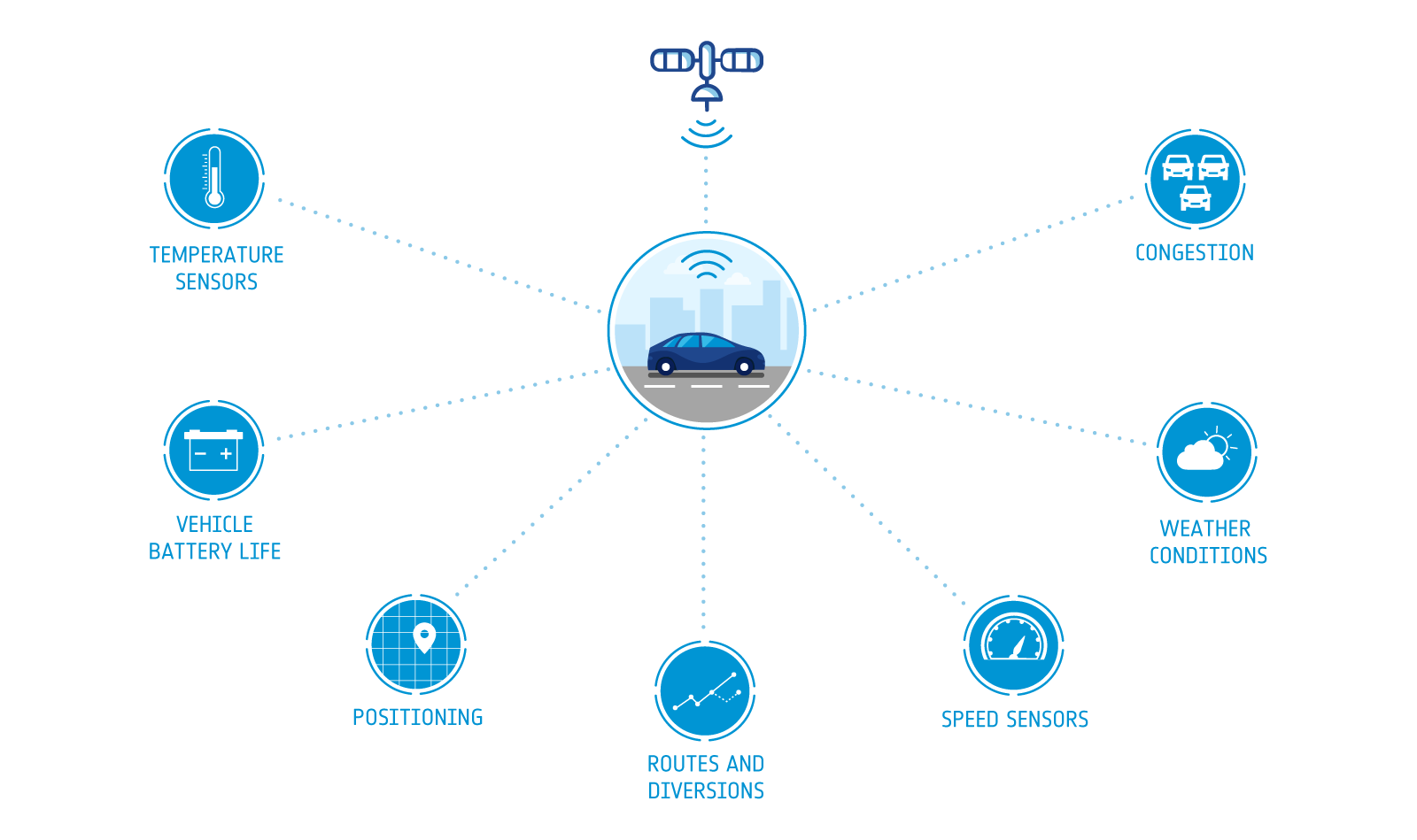
This data can take a variety of forms, including:
- Temperature sensors
- Vehicle battery life
- Positioning
- Routes and diversions
- Speed sensors
- Weather conditions
- Congestion
- And more
Satellite communication services will be used to ensure the transmission of data is both continuous and reliable. This includes remote locations and times/places where terrestrial communications are absent or unreliable.
Here, we explore the impact of space data on smart transport and logistics, as well as a number of current and potential future uses.

What Opportunities Are There for Space Data in the Transport & Logistics Sector?
There are numerous present and future opportunities for space data in the transport and logistics sector, here we explain what these are and their potential implications.
Public Transport
In the coming years, technological advancements like the Internet of Things are set to revamp complete infrastructures, including public transport networks.
Bus timetables won’t work in the same way they currently do. For instance, users will send a signal to the bus about the time and location of their pick up. The closest vehicle will divert its route to pick up the passenger.
Satellite technology will also enable the regular maintenance and upkeep of public transport. Trains, for instance, will be able to send data to the local transfer hub notifying the relevant companies that specific carriages need assistance. For example, if a carriage on a train is overused or requires maintenance, the vehicle can notify the transfer hub of this before it creates a problem.
This will allow for a more efficient use of public transport while simultaneously bringing operation costs down.

Vehicle & Driver Communication
Vehicles of the future will be able to receive a constant stream of data from transport hubs and satellites.
For instance, satellites will be able to spot severe weather conditions like snow storms. This information will be communicated with the local transfer hub. This will in turn send a notification to every vehicle in the affected area. The car will then communicate to the driver/passenger that the battery is running low and the wheels are not suitable for the conditions expected. The car will be able to use satellite navigation to find an optimal route to the closest service stop.
Long haul truck drivers will also be able to utilise satellite data to their advantage. A tachometer will signal to a driver that they need to rest soon. The current planned route will be considered to ensure the driver has an opportunity to stop and rest while also refuelling to ensure their journey can be as efficient as possible.

Ships, Ports and Pollution Management
When ships arrive to a port, the two hubs will be able to communicate with each other about capacity and requirements. For example, a ship’s number of containers and capacity will be useful logistic information for ports to ensure maximum efficiency and safety.
Ships will also be able to make use of space data. Sensitive containers can be monitored by temperature sensors, to ensure goods are kept safe. Location of assets will also be tracked to reduce loss and potential theft. Satellite communications will share this information with the relevant transport hubs. The regular tracking of location, speed and course via GNSS (Global Navigation Satellite Systems) and satellite communications will enable transport hubs to monitor the progress of journeys and offer real time route updates.
Satellite information will also allow for the monitoring of sea, land and air pollution. If pollution exceeds a set amount, ports can request some ships to wait until the port is less congested and thus less polluted.
Traffic and Accident Management
The use of satellite data will help alleviate some congestion on our roads. When accidents occur or there are specific periods of high traffic, Earth orbiting satellites will be able to spot these and notify transport hubs. These transport hubs will be able to notify vehicles in the surrounding area and divert them to a shorter or more efficient route.
When an accident does occur, the vehicles involved can send an automatic notification to the local transport hub. The severity of the accident will be known almost immediately so that, if needed, emergency services can be dispatched. GNSS technology will ensure the incident’s location is immediately known to the emergency services.
The Use of Drones
There are two clear uses of drones in the transport industry of the future.
First up, we have delivery drones. These will cover everything from fast food to important packages. These drones will be tracked to ensure the successful delivery of packages. They will also communicate with their surroundings to ensure there’s no chance of a collision. The precise location of delivery and monitoring of battery life will also require the use of satellite communications.
If road accidents do ever occur, ambulance drones could become the ideal choice of first responder. These can be deployed to attend the incident and offer vital aid to assist those involved. These will utilise both GNSS and satellite communications to ensure the immediate transfer of data as well as accurate navigation information.
Vital Statistics for the Future of the Smart Transport & Logistics Sector
It’s one thing making predictions for the future of the smart transport and logistics sector, it’s another supporting these predictions with statistics and data.
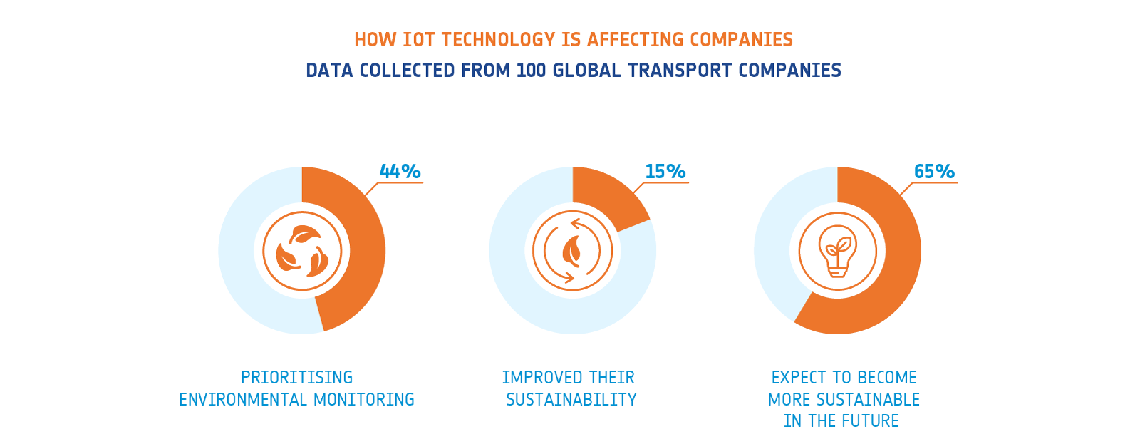
In a recent report, Inmarsat collected data from 100 large global transportation companies. 44% of the companies surveyed stated that they’re prioritising environmental monitoring as a key area for IoT deployment. Further to this, 15% explained that they had improved their environmental sustainability as a result of IoT deployment. 65% of those mentioned above expect to become more sustainable in the future as a result of this technology.
The importance of emerging technology extends beyond businesses becoming more sustainable. As transport demands increase over time, it’s expected that global CO2 emissions from transport will increase by 60% by 2050. This increase is based on the assumption that the use of green technology in transport will be more widespread. If this is not the case, this figure is believed to be significantly higher.

Current Uses of Space Data in the Smart Transport & Logistics Sector
There are plenty of businesses already making strides in utilising space data to impact the smart transport and logistics sector. Here are a number of the projects which have received support from ESA-BA in this area:
Monitoring Hazardous Goods – SaMoLoSa
SaMoLoSa tracks and monitors the transport of hazardous goods by unpowered assets. This type of transport is difficult to monitor in real time. The project makes use of satellite data to alleviate this. This technology will monitor set parameters input to complement stakeholder news and requirements. This tracking will ensure a safe and reliable journey.
This goes beyond simple loss prevention. The sheer amount of information gathered will help optimise logistics and identify areas for improvement.
Winter Road Maintenance – Assist WRM
The winter road maintenance sector is worth an estimated €75 million in Europe alone. Considering this, there’s a real opportunity for space data to innovate current processes and technology. The Assist WRM project looks to use satellite navigation technology and Earth orbiting satellite imagery to provide a full (and potentially automatic) control of winter maintenance equipment and optimisation of operations to reduce manual intervention. Allowing operators to focus on simply driving the vehicle.

Intelligent Cargo Monitoring – RTICM
The RTICM project looks to offer a cost-effective way of monitoring and controlling the transport supply chain of high value containers around the world. This covers all modes of transport and aims to help stakeholders make real-time corrective actions to prevent loss and improve efficiency. The project uses global satellite communications and satellite navigation for both tracking and data transmission.

Automated On-Demand Courier Service – TeleRetail
TeleRetail is developing an automated delivery service which uses courier robots for urban and sub-urban use. These self-driving vehicles are ordered by a user on-demand and delivers the products locally on the same day. This technology will allow for cost effective, energy preserving and space efficient urban logistics.
The project will use:
- Satellite navigation to help with journey accuracy
- Satellite communication to aid with asset tracking
- Earth observation satellites to assist with urban mapping

Funding Opportunities for the Smart Transport & Logistics Sector
ESA Business Applications offers funding and support to businesses in the smart transport and logistics sector looking to utilise space enabled technologies for new commercial services. This is more than a simple funding opportunity. Businesses will receive zero-equity funding, project management assistance, access to our network as well as the credibility of the ESA-BA name. Explore our funding opportunities here.


