Objectives of the service
The objectives of Aquafarm are to provide customers with easy access to information on crop development through a simple API and user-friendly visualization tools. Customers can also try products immediately using the prepared visualization tools. Aquafarm has the capability to ingest customers' defined polygons, allowing for customized analysis and monitoring.
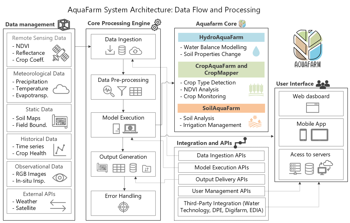
Aquafarm integrates data from various sources such as satellite imagery, meteorological models, meteorological measurements, and plant growth models. By combining these data sources, Aquafarm generates modeling results and insights about plant growth and soil conditions. The platform has versatile interfaces for input and output, enabling the management of different models and data. Aquafarm is accessible worldwide and can be connected to locally collected data, enhancing its versatility and adaptability. It leverages historical production data to improve its forecasting capabilities. Additionally, Aquafarm is being utilized by other platforms that distribute information to farmers, further extending its reach and impact.
Users and their needs
Aquafarm provides to the needs of water managers, governments, and farmers associations. By providing access to data and models with low maintenance costs and high durability, Aquafarm supports these users in improving the agricultural value chain. Users can monitor water usage and crop growth, enabling proactive responses to water use and facilitating sustainable agricultural practices. For water managers, Aquafarm assists in optimizing water resources for agriculture. Governments can continuously monitor farmers and address specific issues promptly, such as providing subsidies and support.
IFAP uses the system to monitor crop declarations and ensure compliance for subsidy allocation; DPE/WT applied AquaFarm for watershed-scale modeling and water balance validation; EDIA benefits from detailed parcel-scale insights and simulations that support irrigation optimization and strategic water management; Digifarm leverages the platform for automated crop monitoring and predictive analytics; and Wisecrop integrates AquaFarm outputs into its digital services to assist farmers with real-time field assessments. These use cases highlight AquaFarm’s flexibility to support both regulatory and operational objectives.
Service/ system concept
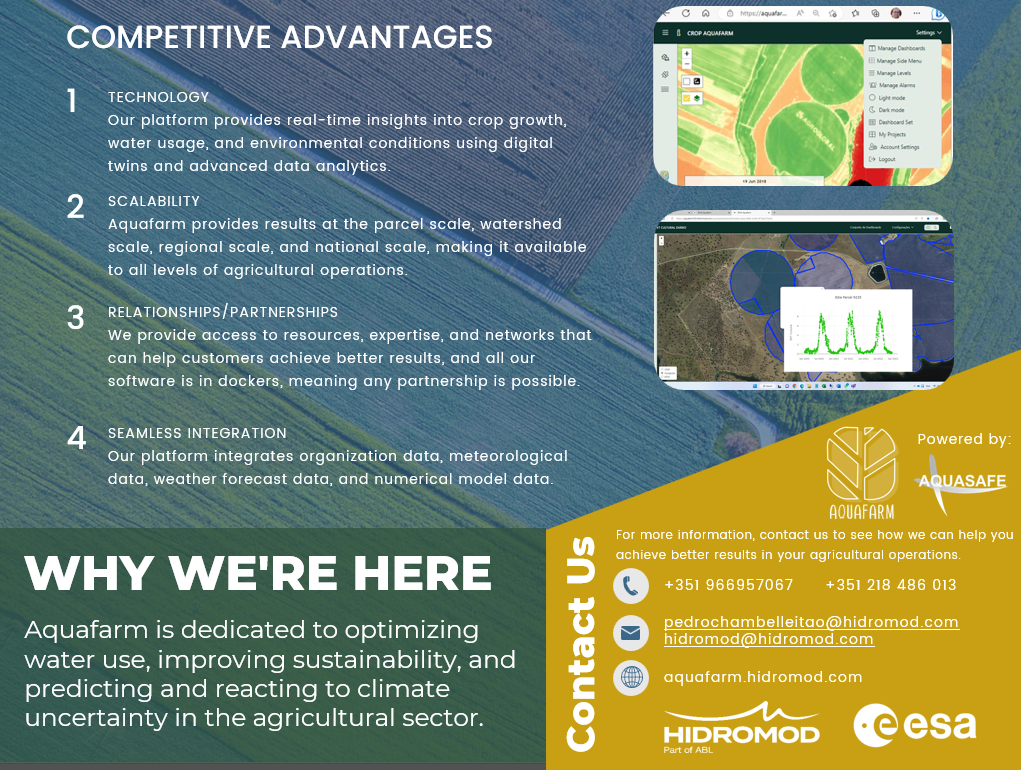
Aquafarm is a platform that integrates remote sensing techniques, satellite data, meteorological models, and local measurements to provide real-time insights into crop growth, water usage, and environmental conditions. It utilizes advanced numerical modeling, satellite imagery, and data integration to generate accurate modeling and forecasting results. Aquafarm offers three modules: HydroAquafarm, CropAquafarm, and SoilAquafarm, each addressing specific aspects of water balance, crop monitoring, and soil characterization. The platform transitioned to a service-based model, providing its functionalities to interested parties, and offers Aquafarm-Specific Services focused on water management, crop monitoring, environmental conditions, decision support, and sustainable agriculture practices.
Space Added Value
The space added value Aquafarm, lies in its utilization of satellite data, particularly from the Sentinel-2 mission. Sentinel-2 optical data plays a crucial role in the system by enabling remote monitoring of vegetation. This data is utilized in the Satellite Processing Block of Aquafarm to retrieve and process information such as biophysical vegetation status indicators, dynamic cropland masks, and cultivated crop types.
It is worth noting that while the current version of Aquafarm primarily relies on Sentinel-2 optical data, the system has the potential to expand and incorporate more detailed satellite data in the future. This adaptability and scalability further contribute to the space added value of Aquafarm.
Current Status
Aquafarm has evolved from a kick-start activity supported by ESA to a comprehensive platform with multiple modules and services. It has successfully conducted a pilot stage, establishing contracts with users like IFAP—whose contract was recently renewed—and attracting new users through successful demonstrations with Wisecrop, EDIA, Digifarm, and Water Technology. Aquafarm 2.0 is the latest version of the platform, incorporating advanced technologies and models for water balance, crop monitoring, and soil characterization. It has demonstrated its effectiveness in optimizing water resources, improving crop management, and supporting sustainable agriculture practices. The platform’s success led to a formal Contract Change Notice (CCN) for the 2024–2025 period, strengthening its development and operational scope. Notably, a contract with the NSW Department of Planning and Environment (DPE) enabled the validation of AquaFarm’s watershed-scale modeling capabilities. Additionally, great commercial leads are emerging from major players in the agricultural sector, paving the way for broader market expansion and long-term adoption. The recent acquisition of Hidromod by ABL—a global consultancy with offices in over 40 countries—further enhances AquaFarm’s global outreach and commercial potential.