
Objectives of the service

Image credit: Dlapilota
The BFPaaS objectives are closely linked to the current procedures developed for UAV BVLOS flights control within the frame of EU U-Space program. In principle, the drone operator is responsible for his /her operations security, that especially in the pre-flight phase, requires detailed knowledge of the terrain profile along the planned route which is crucial for security reasons.
Poland is one of the leading countries in EU if it comes to BVLOS flights, but at the current stage there are no solutions available in the market allowing drone pilots to assess properly the terrain profile related risk, especially in areas where update data are not available. Other Countries will follow shortly.
The objective is to simplify the current process to request a flight permission, just by submitting the flight details from a mobile phone application – even just by drawing a line on the map- with possibility to automatically calculate and provide the terrain profile along the selected route.
Users and their needs
- DSM – Digital Surface Model are often not updated and not sufficiently accurate
- Until today, most of the times terrain models are used without knowing their origin and date of collection
- When flying out of sight, the operator is responsible for mitigating the risks associated with a potential collision with the ground
Service/ system concept
- The new service is expected to fill the clearly visible gap in UAV BVLOS flight planning process, especially in the safety (pre-flight risk analysis) and data collection accuracy dimensions (e.g. for flights at constant height).
- Benefits of the service could not be limited to the UAV flights planning and execution, for example the automated terrain analysis could become one of the vital elements of the future universal platform(s) addressing the complete range of UAV BVLOS flights operators needs, from the mission planning to the processing of the acquired data - possibly available not only for Poland but also at least for all EU countries after the expected changes to UAV flights legal status.
- Another important feature of the service is the possibility to provide actual and accuracy adjusted precise terrain profiles to air authorities and commercial aviation companies, for example for the purpose of low altitude or low visibility flights planning or for terrain obstacles or unsupervised landing sites monitoring requiring instant terrain protection for Instrumental Procedures.
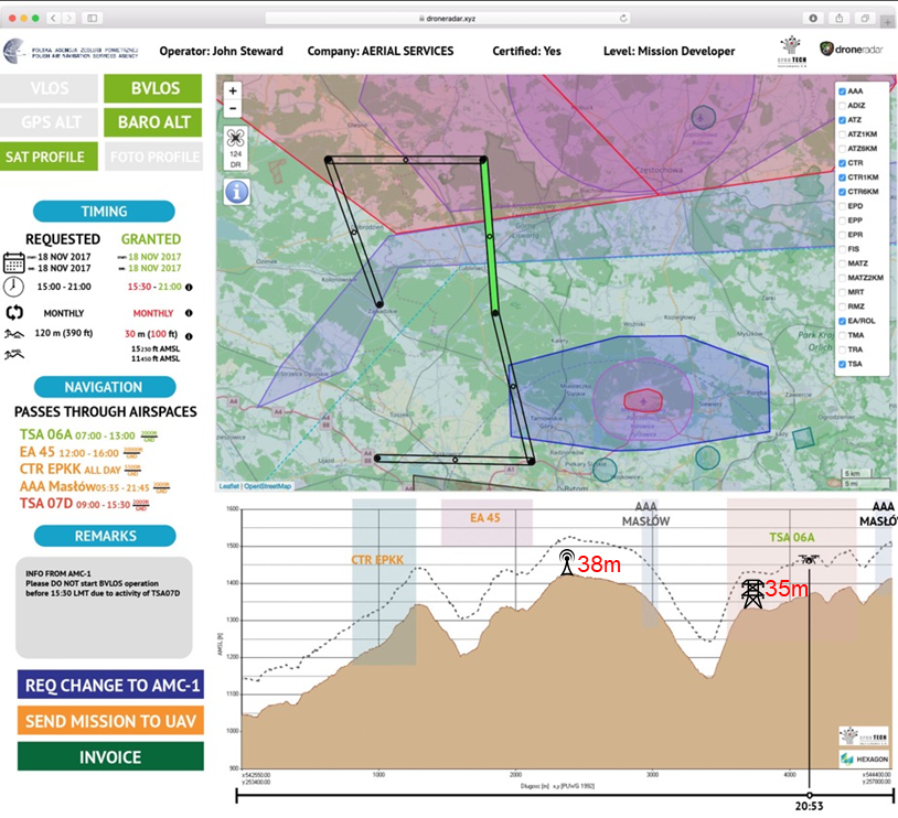
Image credit: Dlapilota
Space Added Value
Radar observations serve as a base for perpetual automated change detection analysis in the selected areas of interest. Due to frequent revisit and acquisition condition resistance Sentinel 1 will act as Geomatic Remote EYe almost constantly watching for phenomena that create the possibility of elevation changes on terrain surface, like developing infrastructure or buildings demolish.
BFPaaS elevation data repository is to be periodically updated, accordingly to users needs, by products resulting from Copernicus Sentinel 1 radar data interferometry processing (as well as any other possible to acquire elevation data), providing updated terrain profiles and adding value as compared to currently used solutions, mostly based on SRTM digital elevation model.
Current Status
The BFPaaS project has been completed with promising results, the most important commercial prospects are related to the launch and successful certification of the PansaUTM system and the official requirements for BVLOS flights planning.
The team will still perform further developments in order to reach the full commercialization stage. The developments include:
- high-resolution Digital Surface Model for the whole area of Poland ready-to-use has been conducted beyond the initial scope,
- development of the Content Management System platform, taking into account cybersecurity aspects
- preparation for performance tests necessary for possible connection to the PansaUTM system
- data loading time analysis
- completing API documentation to make it public