Objectives of the service
BIOSCOPE has set up a reliable and affordable service for farm managers and farm advisors for crop monitoring based on the integrated use of satellites and drones. Satellite images bring the ability to
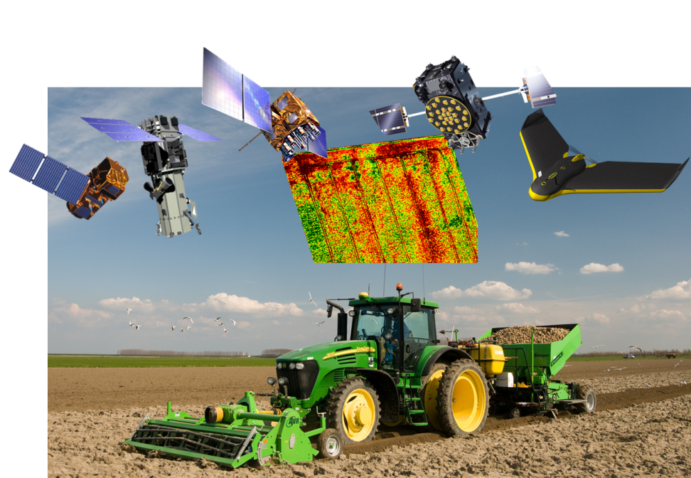
capture a wide area in one go, and to acquire systematic, standardised and up-to-date information. Where satellite imagery is not sufficient in terms of resolution (spatial), coverage (clouds) or timing (short term planning), BIOSCOPE will acquire complementary imagery using drones.
This BIOSCOPE Service is the result of a successful feasibility and Demonstration study.
Users and their needs
The primary market for BIOSCOPE consists of the arable farmer in Europe. The service targets two segments of the crop cultivation: Farm managers and farm advisors. This includes farmers, agronomists, extension services, laboratory’s and contractors. Remote Sensing based information products can support agricultural users in decision making in many different processes. Agricultural users have clear demands, that BIOSCOPE has translated in clear requirements and specifications for the service: Minimizing risks in the crop growth, increase crop quality, easier scouting and reduce the leakage of fertilisers, pesticides and other crop inputs to the environment are the main user needs. These result in increased profitability for the farmer and reducing environmental impacts. This results in the requirement for a guarantee to delivered information products in predefined time windows. Furthermore, the data must be directly usable, not more than ten days old and cost-effective.
Service/ system concept
The objective of this study was to start up a Fast, Flexible, Timely and Reliable service that deliver relevant information with an advice to the farmer. For this purpose, BIOSCOPE chooses an appropriate mix of satellite and drone image acquisitions, to best meet the customer's requirements (e.g. timing, and resolution) based on satellite availability and weather condition. Thereby the service will foster a wider use of satellite imagery with a key role of data from the Copernicus Sentinel-2 mission.
The BIOSCOPE service provides the complete data value chain from the farmer’s management system to the satellite and back to the field and to the machinery that performs the task in the field. The Remote Sensing information is integrated in the standard agricultural processes as well as the standard agricultural software, guaranteeing ease-of-use to the farmer. Using standard data protocols to exchange the data between the BIOSCOPE system and the farm management systems will guarantee a significant level of acceptance among the farming community.
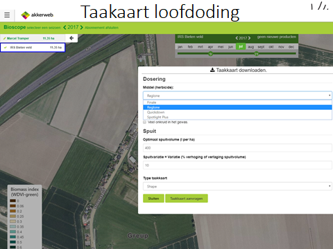
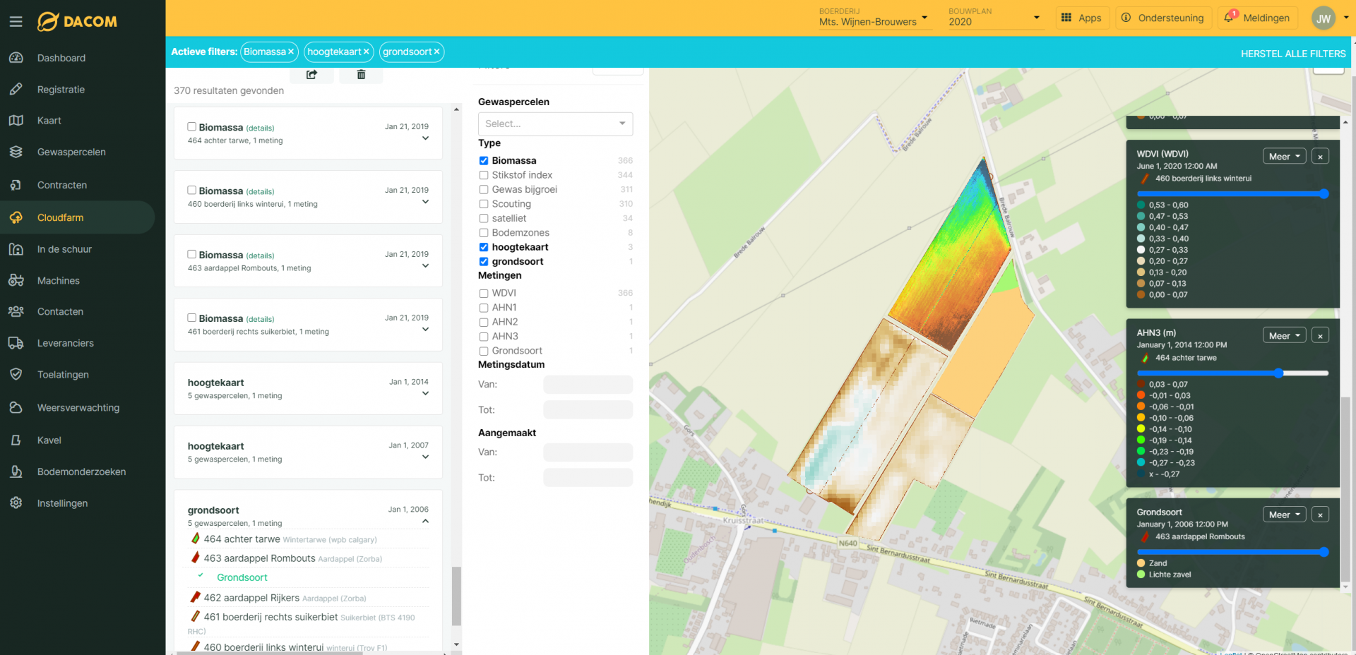
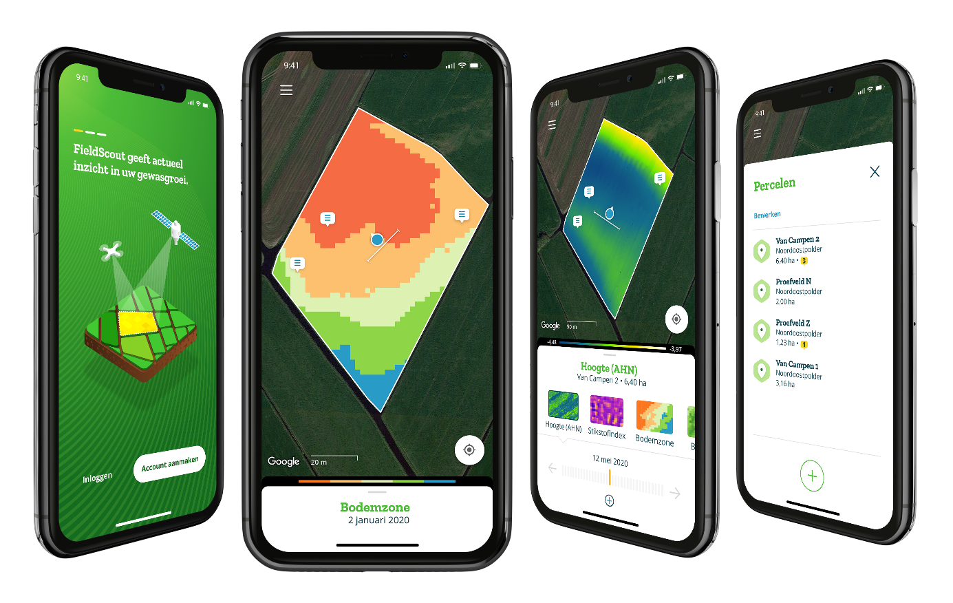
Beside the integration with farm management software (desktop) we develop a smartphone app to guarantee a very simple way to take the BIOSCOPE products into the field, scout the crop and take actions. With this App farmers can even order the data from the field if a farmer sees a deviation in the crop or soil.
Space Added Value
BIOSCOPE makes use of two space assets, Earth Observation and Satellite Navigation:
- Earth Observation is used for the service itself, in particular the very high-resolution sensors in the visible and near-infrared parts of the spectrum;
- Earth Observation is also used for the monitoring of clouds and the weather forecast for the ‘switch’ in the procurement of satellite data and airborne data. METEOSAT is used to monitor if the expected (non) cloud conditions are indeed happening.
- EGNSS including EGNOS is used for auto guidance of the drone and the telephones using the FieldScout app. It is also used for geotagging photos and notes in the field;
- Satellite Navigation is also used to deploy the services outputs (e.g. task maps) in the field with Variable Rate Application.
Current Status
The BIOSCOPE Demonstration Project started early 2016. Building on the analysis of interviews with farmers and other stakeholders to frame better the actual user demand for BIOSCOPE, the Baseline Design Review has been completed in April 2016. In Marche 2017 the Factory Acceptance Test was passed. That means that the all components are integrated and tested. In the months after the FAT the team improved the integration and made the service ready for the demonstration phase. In May 2017 the on-Site Acceptance Test was passed and the demonstration phase started with the upcoming potato growing season. The demonstration phase of the project focused on potato farming in the main potato areas of the Netherlands. The demonstration phase ended in October 2017 and in May 2018 the final review was done.
The project continued with a CCN to improve the system and expand the product portfolio. In the meantime, the Bioscope B.V was set up and the system was improved by the user feedback of the demonstration phase. After the 2018 and 2019 potato season we collected valuable user feedback and collected clear ideas on improvements for the design of the service and new components (improved user interface Cloudfarm, the FieldScout app including Webshop and the soil zone map and Quantified soil maps) were added. These new components were demonstrated during the growing season of 2020. The project was concluded in October 2020.
BIOSCOPE is commercially available in the Netherlands and Belgium and will be expanded to the rest of Europe in the near future.
Prime Contractor(s)
Subcontractor(s)