Objectives of the service
The project studies the feasibility of an operational system for marine route optimisation, which integrates modelling and forecasts of ocean currents based on near-real time satellite altimetry data. The operation of ships is affected by a number of environmental influences such as tides, currents, waves and winds. In most oceans, there are regular currents that ships may be able to avoid or exploit for faster passage.
Dynamic currents have largely been neglected in earlier routing studies because, until recently, there has been no way to obtain reliable and timely estimates of dynamic current patterns. However, technological developments in satellite altimetry now offer the potential for providing accurate estimates of currents, wind speed, and wave height that can be used to improve ship routing. These data can be assimilated into an oceanographic model of current patterns or be used as direct estimates of current and wind velocities.
The service will enable operators to minimize fuel consumption and reduce the fuel cost, thus increasing their profit. In addition, given that ship air emissions are related to fuel consumption, the service also minimizes the environmental impact of ship voyages and has a clear societal and environmental effect.
Users and their needs
The shipping companies are the most important user group followed by companies on the supplier side for systems and services used for route optimisation, planning and navigation.
The shipping sector has a wide range of different assets such as container ships, tankers, dry cargo and bulk carriers, cruise ships, passenger ferries, ro-ro ships, and supply ships for the offshore industry. The users involved represent most of the shipping sector as described here and also navy vessels.
On the background of stakeholder analysis the main users’ needs are:
• Data need to be easy to access and to understand
• Data must not be heavy in terms of mega bites and they have to be quick to download
• New data shall be deliverable without having to install new hardware
• Ocean currents is the data component, where present low reliability poses the largest cost
The key challenges for the underlying system in the service provision chain are the availability of Earth observation data and the quality of the data assimilation into general ocean models. Other challenges are to ensure availability and quality of tidal currents within the service, the reliability and timeliness of metocean forecast production, and the operational definition of interfaces between the individual steps in the system chain.
The targeted users are from European countries with large maritime activities (Greece, UK, Spain, Italy, Norway, Germany, Denmark, Netherlands, France, and Sweden).
Service/ system concept
The service is based on a ship integrated system providing real-time marine routing, integrating Earth Observation data and information about and from the sea-going vessel. The service can:
• Deliver more accurate ocean currents prediction by including all components of the currents
• Provide more accurate ocean current by assimilating near-real time ocean current/wind speed
• Predict metocean parameters at higher spatial resolution in coastal regions
• Provide water-forecast precision/accuracy by using two MetOcean models in parallel.
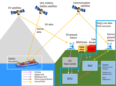
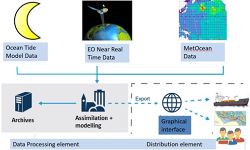
The figure highlights the system architecture with a data processing element (including collection fusion and processing of the data) and a distribution element (including graphical user interface and push-functionality).
The input of the historical and forecast weather data to our model is a GRIB file (standardised by WMO) that contains all information on ocean currents (direction speed, u and v component of current), winds (direction and speed) and waves (direction and significant height). The service further uses ship data (geometric characteristics of the vessel (e.g. length, breath), stability and hydrostatic data, operational characteristics (e.g. cargo load, fuel consumption, speed, etc.), AIS data and others) and the trip data (port of calls, expected arrival times, including contractual agreements).
Space Added Value
This product is the first of its kind to take advantage of the ESA GOCE higher level products derived from a geostrophic current model, integrating Cryosat-2, Jason-2 & -3, Sentinel-3A/3B and, in the future, Sentinel-6 altimetry. An advantage of the product is that the service will be able to provide both total currents and directions, where the total currents are the sum of weather, tidal and permanent ocean currents and the current acting on the ship.
It was a clear conclusion from the user analysis that for a next generation of route optimisation the users require a service with a high-resolution current and reliability estimates on the data. BlueSIROS will be able to provide both services and thus be different from existing competitors.
BlueSIROS will also be able to provide data for both water forecast and water hind-cast for analysis of vessel performance (so-called noon-reports).
Current Status
The Feasibility Study has now been completed, and in a proof-of-concept as part of the study we have estimated that the fuel savings that can be obtained by using improved satellite altimetry information for the ocean currents on selected distances can be substantial. For optimum conditions, here the ship is affected by significant currents, the savings can be in the order of 8-17 %. For a full voyage, the total fuel savings will be smaller, but it highlights the great potential for improved route planning using EO enriched data in a service such as the proposed BlueSIROS.
The outcome of the feasibility study led to the application for a follow-on Demonstration Project led by DHI.