Objectives of the service
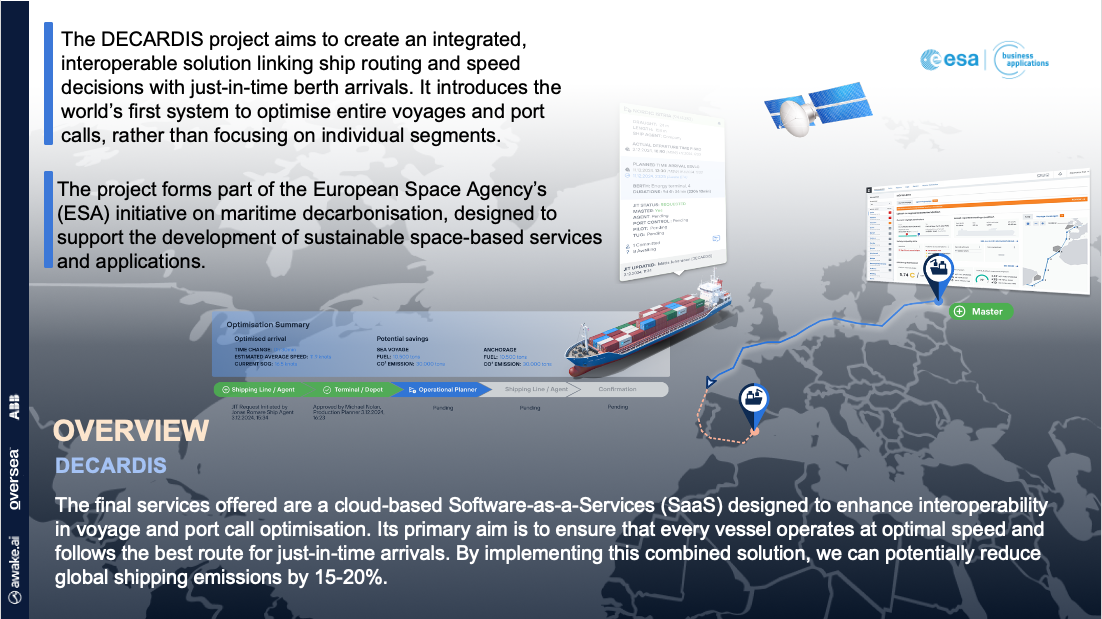
The solution will provide users with the ability to plan a fully optimized vessel route from the berth at the port of origin, to the berth at the destination port ensuring a Just-In-Time (JIT) voyage and port call operation.
The goal of the combined solution is to improve information sharing between stakeholders and enable every vessel to always operate with optimal speed and take the optimal route for just-in-time arrivals. This can reduce the global shipping emissions by 15-20%.
Users and their needs
The solution is designed to meet the needs of key maritime stakeholders, including port authorities, terminal operators, shipping agents, shipping lines, cargo owners, vessel masters, and superintendents worldwide.
These industries face common needs such as:
-
Optimised Berth-to-Berth Voyages
-
Ship operators and port operators need to enhance operational efficiency by facilitating real-time information sharing on vessel movements, port operations, and avoid potential delays.
-
-
Cost Reduction & Sustainability
-
Ship operators need to minimise fuel consumption, emissions, and unnecessary costs by precisely synchronising vessel arrivals and departures with berth availability.
-
Port operators need to reduce waiting times through optimised scheduling, ensuring seamless Just-in-Time (JIT) arrival of the vessel.
-
-
Enhanced Supply Chain Reliability
-
Cargo owners need to improve the predictability and efficiency of global supply chains by ensuring vessels arrive and depart on schedule.
-
-
Increased Port Efficiency & Security
-
Port operators need to streamline port operations with a structured and coordinated approach, enabling a smoother, more secure, and efficient flow of vessels.
-
Service/ system concept
The DECARDIS solution comprises two core integrated services:
-
The Port Call Optimisation Service – Streamlining port operations and vessel visits to improve coordination and reduce costs.
-
The Voyage & Fleet Support Service – Optimising vessel speed and route to enhance safety, efficiency and sustainability.
Users can seamlessly conduct optimisations via an intuitive web-based application, integrating with existing onboard systems and application programming interfaces (APIs). Both services are delivered as a Software-as-a-Service (SaaS) solution, which ensures ease of access, scalability, and expert support.
Port Call Optimisation Service
The port call optimization service facilitates real-time data collection and sharing, among key stakeholders throughout the port call phase. By leveraging accurate and reliable information, it enables the creation of a Just-in-Time (JIT) port call plan, allowing all parties to coordinate and agree on the optimal arrival time—reducing fuel consumption and emissions.
Upon completion of the port call, the system automatically analyses performance and generates comprehensive KPI reports, covering:
-
Emissions
-
Berth usage
-
Waiting times
-
Planning accuracy
Voyage & Fleet Support Service
The voyage and fleet support service includes both a cutting-edge digital solution as well as support from specialised personnel. Aiming at helping clients to continuously improve vessel operational performance, the service empowers customers to:
-
Optimize speed and route for JIT arrival
-
Reduce bunker costs and associated emissions
-
Improve reliability and safety in ship operations
-
Convert data into actionable insights, driving continuous improvements
With the voyage and fleet support service, ship owners, managers and vessel crew can receive support on topics relevant to environmental, technical and voyage performance. The service ensures efficient collaboration and provision of information sharing support 24/7/365. It also enables data to be turned into insights and insights into actionable improvements.
Space Added Value
The solution harnesses cutting-edge space-based technologies to deliver unparalleled maritime optimisation. It integrates data from the entire Sentinel fleet (ESA) alongside Earth Observation data from other satellite providers.
Additionally, Automatic Identification System (AIS) data—including terrestrial, dynamic, and satellite sources—plays a crucial role in enhancing situational awareness. To enable its advanced features, the solution also leverages Satellite Navigation and Satellite Communication technologies, ensuring seamless, real-time data transmission and decision-making support.
By combining these space-based assets, DECARDIS provides great and unique precision, reliability, and efficiency for global maritime operations.
Current Status
User needs were captured through a series of interviews with potential customers. These needs were then translated into service and system requirements, which were subsequently validated by the relevant stakeholders.
The system architecture has been developed and concretised through a series of technical workshops, enabling the definition of system-wide architecture, including system-to-system communication and integrations. This work has fulfilled the commitment to bring the architecture to life in a technically coherent and implementation-ready format.
The Business Plan has been further developed, demonstrating the commercial viability of the proposed solution.
To support commercialisation goals, the proposed solution has been presented to prospective customers at key events. These interactions have yielded valuable feedback, which has been integrated into critical project planning. Furthermore, a strategy for system distribution has been initiated, including a review of delivery models, to ensure scalability and accessibility for future users.
Through these activities, the project has delivered on the planned transition from design refinement to implementation planning, while continuing to engage with future customers to secure commercial success.
As the project progresses, preparations are underway for the next phase which includes development of all necessary functionalities to demonstrate technical feasibility.
Prime Contractor(s)