
Objectives of the service
Modern society heavily relies on a number of critical infrastructures (CI) such as for electricity generation and transmission, water supply, transportation systems or telecommunication. In the Alps, the vulnerability of CI to natural disasters, however, has increased with the growing demand for land and predicted climate change. Regarding floods, appropriate forecasting and warning systems can reduce the potential negative consequences. But up to now, accurate flood forecasts are rarely available for medium size Alpine catchments, where current forecasting technologies do not have the necessary high temporal and spatial resolution.
EFFORS overcomes this limitation by using space technologies because they allow the integration of insitu measurements and current land surface conditions (snow coverage, land use) within flood forecasting. An international team out of specialists for satellite communication, earth observation, meteorology, informatics, hydraulics and hydrology work hand in hand with user representatives, to elaborate a new system structure aimed at closely meeting the needs of the user communities.
Service/ system concept
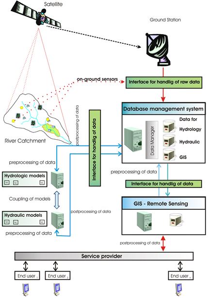
The new service is driven by user and stakeholder requirements on the one side, by technical expert knowledge on the other. The intention of the proposed service is to collect, combine and process heterogeneous data and to deliver the final information directly to the users. The technical concept foresees a network of on-ground sensors to measure key parameters of the area of interest (e.g. water level, discharges, and precipitation). The collected data are transmitted via either satellite or terrestrial communications networks to a processing centre. In order to reduce the communication costs, sensors are activated using threshold values.
The processing centre performs an integration of the data with satellite imagery. These data are inputs of the hydrological model coupled with the hydrodynamic model. In this way, models take into account the floodplains and calculate flood extension, water level and velocity on the floodplain. Post-processing tools should then automatically generate floodplain maps and produce warnings according to the user type. The complete workflow is illustrated on the next Figure.
Space Added Value
The System is based on two space assets:
- SATCOM: ensuring quasi real time data communication in critical situations (floods) and in remote areas.
- EARTH OBSERVATION: for improved (1) precipitation forecasts (2) snow coverage (3) Land Use.
Earth observation: optical data (e.g. MODIS or SUOMI NPP VIIRS) will be used to determine fractional snow covered areas. Maps of wet snow can be derived from Synthetic Aperture Radar (SAR) in woodless areas. Meteorological information will be provided by ZAMG.
Meteorological forecasts: These forecasts are of paramount importance because the fast hydrological reactions in medium size catchments force modellers to simulate flood events before rain is falling. Using sensor information, satellite images, and radar information, meteorological forecasts should be done on small spatial cells and short time steps because of the particular chosen Alpine physical environment.
Satellite communications: Satellite communications is used to transmit the sensor data in near real time to the data processing centre. Satellite communication is not affected by events like floodwater, storms or avalanches. To reduce the costs thresholds are implemented so that satellite communication becomes active only when measured parameters overcome the defined thresholds.
Current Status
The EFFORS feasibility study planned for 12 months started in June 2014 and has been completed with the Final Review on July 1st, 2015. Team members have achieved all deliverables.
This first phase is characterised by two very successful user meetings in Graz (Austria) and in Berchtesgaden (Germany) with around participation of 30 users and stakeholders. Based on the user and the system requirements as well as on the viability analysis, the team defined the system (service definition).
The EFFORS team has prepared a Roadmap which has been submitted to ESA. The consortium has confirmed its interest in initiating and co-funding the IAP Demonstration Project. In this respect, the consortium has prepared an Outline Proposal for a Demonstration Project, which has been submitted to ESA. After its acceptation a Full Proposal will be prepared and submitted for consideration by ESA by mid-November 2015.
The intention is to complete the Demonstration Phase until the operational one. This will happen during the new project period starting probably January 2016. During the Demonstration phase construction of the EFFORS service for two Pilot areas, one in Germany, one in Austria is foreseen. The EFFORS service will be used as a new tool to support flood forecasting and mitigate flood damages
Prime Contractor(s)

Subcontractor(s)