Objectives of the service
Land restoration is interconnected and related to the questions of food security (Sustainable Development Goals of the United Nations → SDG-2), creating sustainable jobs (SDG-8), Land Degradation Neutrality (SDG-15), empowering communities in technologies (SDG-17) and accelerating other conventions on climate change (e.g. REDD+) among others. Land restoration is a multi-sectorial activity that requires common working and coordination efforts from the various stakeholders.
The information derived from the EO-li platform is an important input for public administrations, investors from international donations or private investments funds and governments pledging land degradation neutrality or involved in REDD+ mechanism; they are required for reports by small-holder farmers and indigenous groups, local businesses, NGO’s, seed manufacturers, public and private organizations involved in food-production and/or land restoration, environmental services and CO2 compensation among others.
The newly developed "Earth Observation Location Identifier (EO-li)” is global platform to bring degraded land back into food production. The vision of the EO-li platform is to offer “transparency”, “traceability” and “flexibility” on the various aspects of forest and landscape restoration including the process of its’ implementation.
To bring this vision into practice, the implementation of a restoration project consists of a system of four service components: (i) identifcation of the areas to be restored, (ii) connection of the different stake-holders through a market place system, (iii) monitoring of the progress of the implemented restoration projects, and (iv) awareness raising, strengthening of capacities and technology transfer.
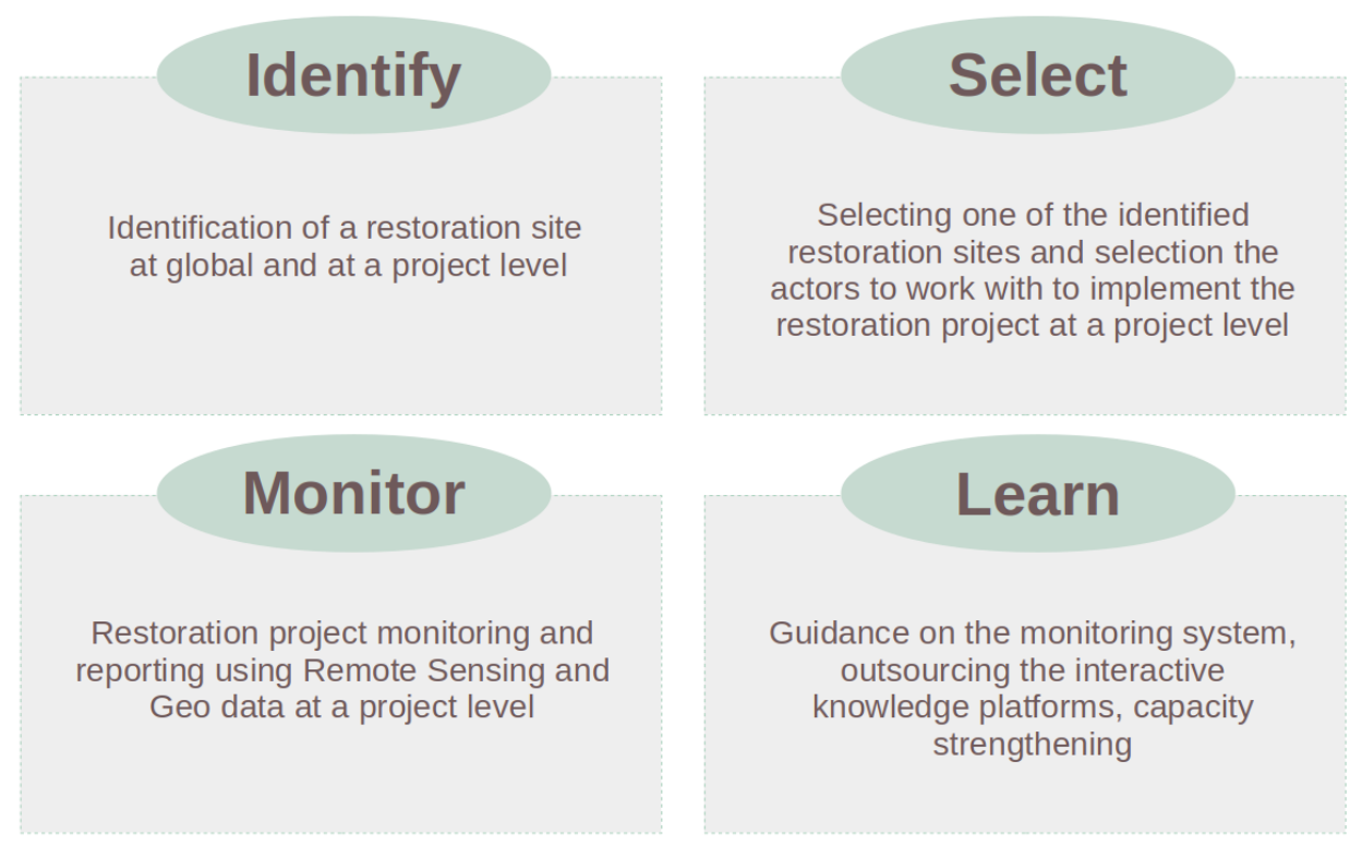
(figure: the main 4 components of EO-li service platform for land restoration)
Users and their needs
The information derived from the EO-li platform is an important input for public administrations, for investors (whether international donors or private investments funds), for governments pledging Land Degradation Neutrality or being involved in the REDD+ mechanism. Furthermore, interested small-holder farmers and indigenous groups, local businesses, NGO’s, seed manufacturers, public and private organizations involved in food-production and/or land restoration, environmental services and CO2 compensation initiatives are among the target group.
There are three main categories of users identified for the EO-li platform:
- beneficiaries: this includes small-holder aggregations, indigenous groups, NGOs, government, civil society in general;
- service providers: this includes earth observation (EO) service providers, tree planting companies, financial technology services;
- investors: this group includes community and local investors, development banks, impact funds, commercial banks, insurance companies, private investors, funds from financial-incentives based conventions (e.g. REDD+).
The user needs can be articulated as follows:
- As the restoration activity starts with the identification of the restoration area, the EO-li platform provides analysis tools utilizing EO and other geographical information to identify an area most suited to restoration efforts (“Identify-component)”.
- As the restoration activity is multi-sectoral, the users need to obtain the characterization of the project area identified for restoration and connect to involved actors to collaborate on the implementation of the restoration project. The EO-li “Select” component allows the user to select the project and enables the other stakeholders to collaborate on the implementation of a restoration project.
- During and after the implementation of the restoration project users need to monitor the area of restoration. The need is expressed as well for the reporting purposes especially for the diverse projects that are in the context of the climate convention or in the context of financial-incentive-based conventions. The EO-li component “Monitor” allows the user to use the cloud computing platform and ready-to-use EO products for area monitoring and for reporting purposes and further analyses.
- Via the 4th EO-li “Learn” component, the user can participate in workshops or even organize workshops for all capacity strengthening purposes.
World wide, Global, Regional and Local scales
Service/ system concept
The EO-li brokerage platform consists of four parts. The restoration activity starts with the identification of the restoration area, here the EO-li platform provides the end user with the component “Identify” that allows the user based on big data to identify the restoration area.
The EO-li component “Select” allows the user to select the project and the other stakeholders to work together on the implementation of the selected restoration project.
The EO-li component “Monitor” allows the user to use related EO data in a cloud computing platform for monitoring of the area and for reporting purposes and further analyses.
Via the 4th component “Learn” of EO-li, the user can organize workshops or participate in workshops for all capacity strengthening purposes.
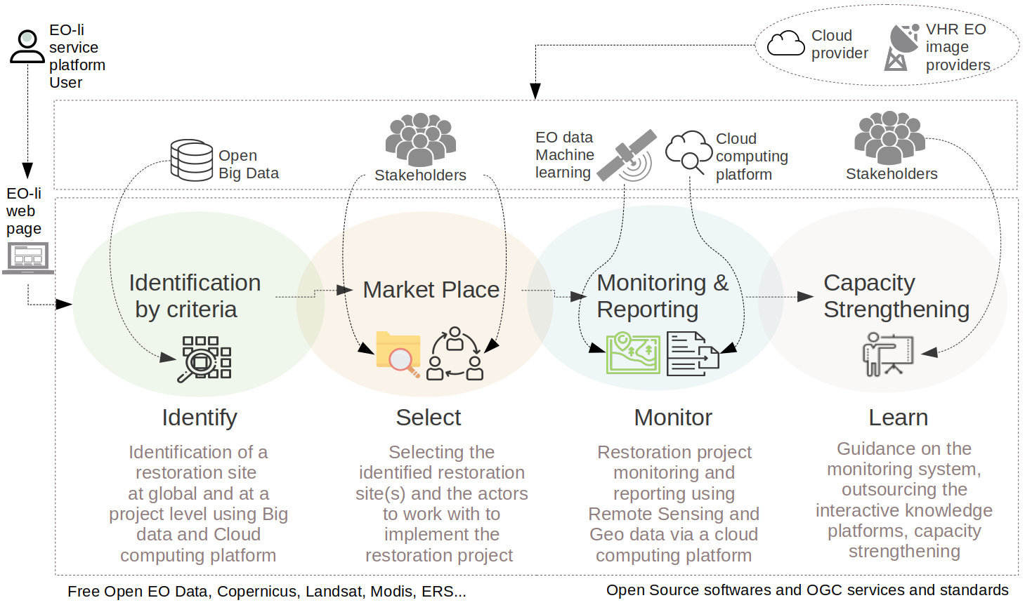
(figure: EO-li Global web based brokerage platform)
Space Added Value
EO-li is using Free Open Earth Observation data from the Copernicus program including Sentinel-1, Sentinel-2, Sentinel-3, Landsat, MODIS, ERS and more. Specific budget provided, it can also include Very High Resolution (VHR) data in case the analyses require high level of detail as provided by VHR capabilities. Some of the derived products from EO data are as follows:
- Above ground biomass map
- Above ground biomass change map
- Land use land cover map
- Land use land cover change map.
Other products from EO based data can be derived based on the various evolving user requirements.
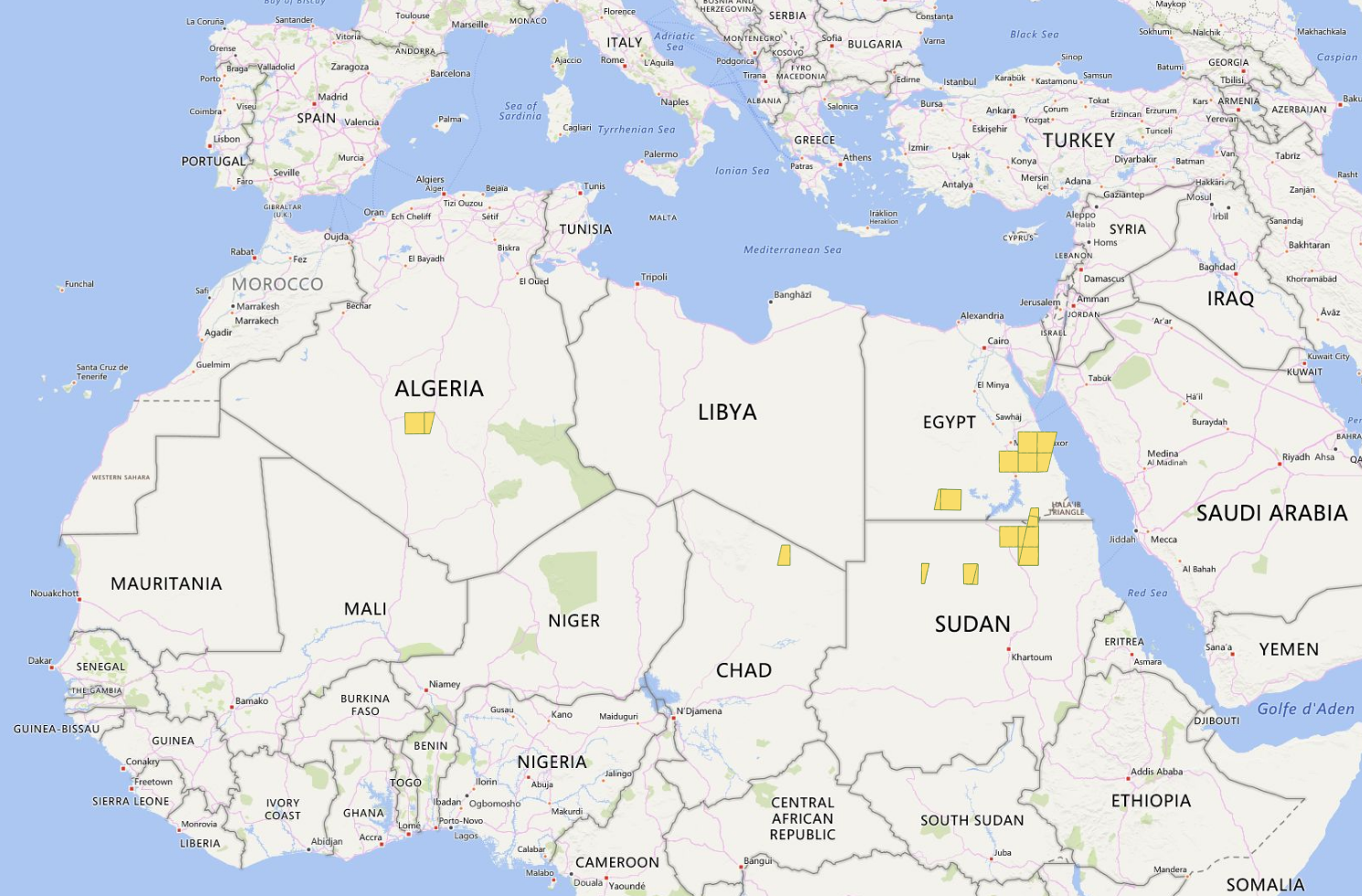 (figure: filter result of the Sentinel-2 images foot prints covering arid areas)
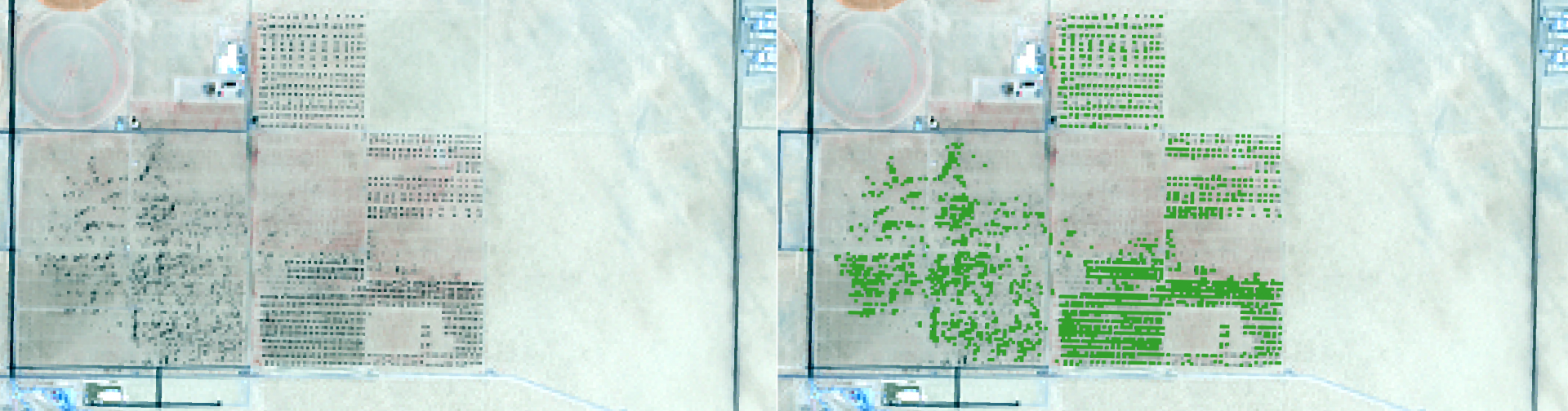
(Figure: Sentinel-2 image, 10 m spatial resolution over a plantation)
Current Status
The EO-li project final review of the conceptual phase was successful. The overall system architecture design is based on identified service requirements. User stories are the basis of the business model.
Currently the team could further collect Letters-of-Intent (LOIs) to involve stakeholders at an early stage. In the spring of 2018 mundialis staff have literally travelled around the world (USA, Brazil, Mongolia, South-Korea) to spread the word about EO-li.
At the Global Landscape Forum - Investment Case in Washington D.C, USA, at the end of May 2018 there was a so-called “Dragons’ Den” event during which selected projects related to land restoration were able to pitch their idea in front of investors and an interested audience. The EO-li project was selected as 1 of 4 projects to present on stage, which we were very honored to do. The video stream of this presentation can be found here:
http://events.globallandscapesforum.org/washingtondc-2018/dragons-den/
(EO-li presentation starts at 44:30 min.)
Prime Contractor(s)

Subcontractor(s)