
Objectives of the service

ESG verification bodies face increasing pressure to assess asset-based sustainability claims using evidence that is defensible, traceable, and independent from company-reported data. Site visits and manual plausibility checks are time-consuming, costly, and often difficult to perform across geographically distributed operations. At the same time, verifiers must manage professional liability and clearly document the limitations of any new analytical tools they use.
The service addresses these challenges by providing independently sourced, satellite-based spatial indicators that support risk-based verification. It transforms Earth Observation data into structured evidence artefacts, including maps, key performance indicators, and time-series trends. These outputs are designed to complement existing assurance workflows rather than replace them.
Delivery is based on defined areas of interest per site, with regularly updated indicators generated from openly available satellite data and optional higher-resolution inputs where needed. Results are presented through a web interface that supports review, interpretation, and export into assurance documentation, enabling more efficient and transparent ESG verification.
Users and their needs
The primary targeted users are ESG verification and assurance bodies assessing sustainability disclosures of asset-based operations such as mining, infrastructure, energy, ports, and land management. The initial focus is on the European Union where regulatory scrutiny is strongest, with relevance extending to the UK and other OECD markets. Key users include verification managers, ESG technical specialists, and methodology teams responsible for assessing the plausibility and completeness of reported claims.
A secondary user group includes ESG reporting and audit workflow platform providers in the EU and UK, who may integrate the service as an external evidence layer to strengthen verifier and corporate reporting processes.
User needs include:
-
Independent, third-party corroboration of asset-level ESG claims
-
Reduced reliance on costly and time-intensive site visits
-
Transparent documentation of data sources, limitations, and confidence levels
-
Seamless integration into existing risk-based assurance workflows
-
Repeatable indicators enabling year-on-year consistency checks
The main challenge is delivering spatial indicators that are transparent, defensible, and easy to integrate thus meeting professional liability expectations without disrupting established verification practices.
Service/ system concept
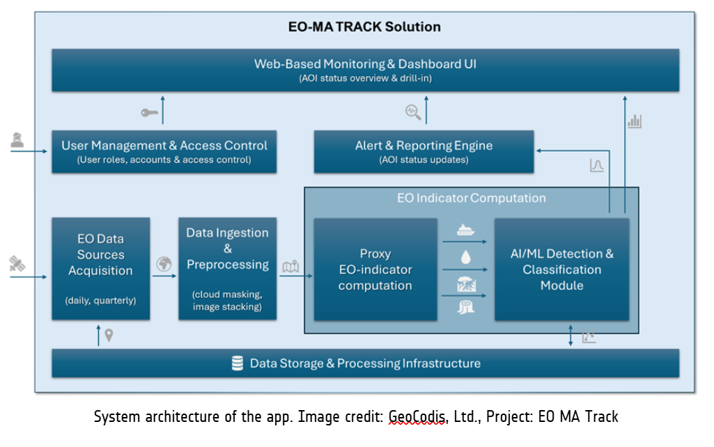
EO-MA Track is a web-based monitoring service that uses satellite data to provide independent, site-level insights for ESG and supply-chain verification. The system delivers clear, visual evidence of observable changes such as land-use disturbance, deforestation, vegetation recovery, built-up expansion, surface water variation, and vessel activity in ports. Users receive spatial maps, key performance indicators (KPIs), and time-series trends showing land-use change, vegetation loss or recovery, built-up expansion, water extent, or vessel activity. Each output is accompanied by metadata, time stamps, confidence levels, and client notes, making it suitable for inclusion in assurance documentation.
Key features include:
-
Configurable Areas of Interest (AOIs) per site
-
EO-based indicators (direct physical change and proxy indicators)
-
Trend analysis across reporting periods
-
Structured evidence exports for verification files
-
Secure web-based dashboard with drill-down visualisation
EO-MA Track automatically retrieves satellite imagery (Sentinel-1 radar and Sentinel-2 optical), processes it to remove cloud effects and noise, and applies detection algorithms to identify meaningful changes over time. Results are structured into easy-to-interpret dashboards.
Space Added Value
EO-MA Track is built primarily on Copernicus Sentinel satellite missions. Sentinel-2 optical imagery provides multispectral data for detecting land-use change, deforestation, vegetation health, and surface water dynamics. Sentinel-1 radar imagery enables cloud-independent monitoring and supports vessel detection and water extent analysis.
The added value of combining these space assets lies in objectivity, scalability, and independence. Traditional verification methods rely heavily on-site visits, self-reported documentation, or periodic audits. Satellite data provide time-stamped, geographically consistent observations across remote and dispersed locations. The integration of optical and radar data improves reliability by mitigating cloud limitations and enabling year-round monitoring.
Compared to competitors using manual assessments or high-cost proprietary imagery, EO-MA Track leverages systematic Copernicus data to provide cost-effective, repeatable monitoring at scale. This allows users to shift from sporadic inspections to continuous, evidence-based oversight, strengthening transparency while reducing operational effort and uncertainty
Current Status
The project has completed its core technical validation phase. EO indicators for land-use change, deforestation, vegetation recovery, built-up expansion, turbidity proxies, and vessel detection were implemented and tested on representative sites, including a port case study and mining-related land-change areas. Time-series outputs and structured KPI formats were demonstrated to ESG verification professionals through targeted engagement sessions, confirming relevance for corroborative assurance use.


On the business side, discussions with prospective verification partners validated the pilot-first adoption model and confirmed interest in limited-scope testing before broader deployment. Indicative pricing logic and recurring-use assumptions were reviewed against verifier budget structures.
A prototype processing chain is operational, supporting automated AOI-based data retrieval and evidence generation. Current work focuses on refining the web-based interface and onboarding workflow. Upcoming activities include structured pilot implementation with selected partners and finalisation of commercial and delivery models for controlled market entry.