
Objectives of the service
FAMOS aims at providing a service for forest status monitoring tailored to the requirements of commercial clients from the commodity sector, especially within the context of cocoa, palm oil, and rubber. Currently the main pilot User is FarmStrong Foundation. FarmStrong Foundation’s main objective is to increase the efficiency in monitoring forest status, afforestation, deforestation, and forest degradation. Due to limited human resources and in order to ensure cost efficiency, a cutting-edge technical approach – using satellite services – is favoured.
The following objectives are crucial for the success of the project:
- Good cost benefit ratio
- Enhanced monitoring of forest status
- Enhanced monitoring of afforestation
- Enhanced monitoring of deforestation and forest degradation
- Reducing in-situ assessments costs
Users and their needs
The targeted user communities are the commercial clients from the commodity sector, especially within the context of cocoa, palm oil, and rubber.
The Pilot User involved in the project is FarmStrong Foundation.
The major needs of the target customers are:
- Up-to-date information on forest status
- Up-to-date information on afforestation
- Up-to-date information on deforestation and forest degradation
Operational challenges
- Data availability due to forest cover in the tropics
The pre-operational service is provided for the Pilot User FarmStrong Foundation. In the operational phase commercial clients from the commodity sector (especially within the context of cocoa, palm oil, and rubber) can also benefit from this service.
Service/ system concept
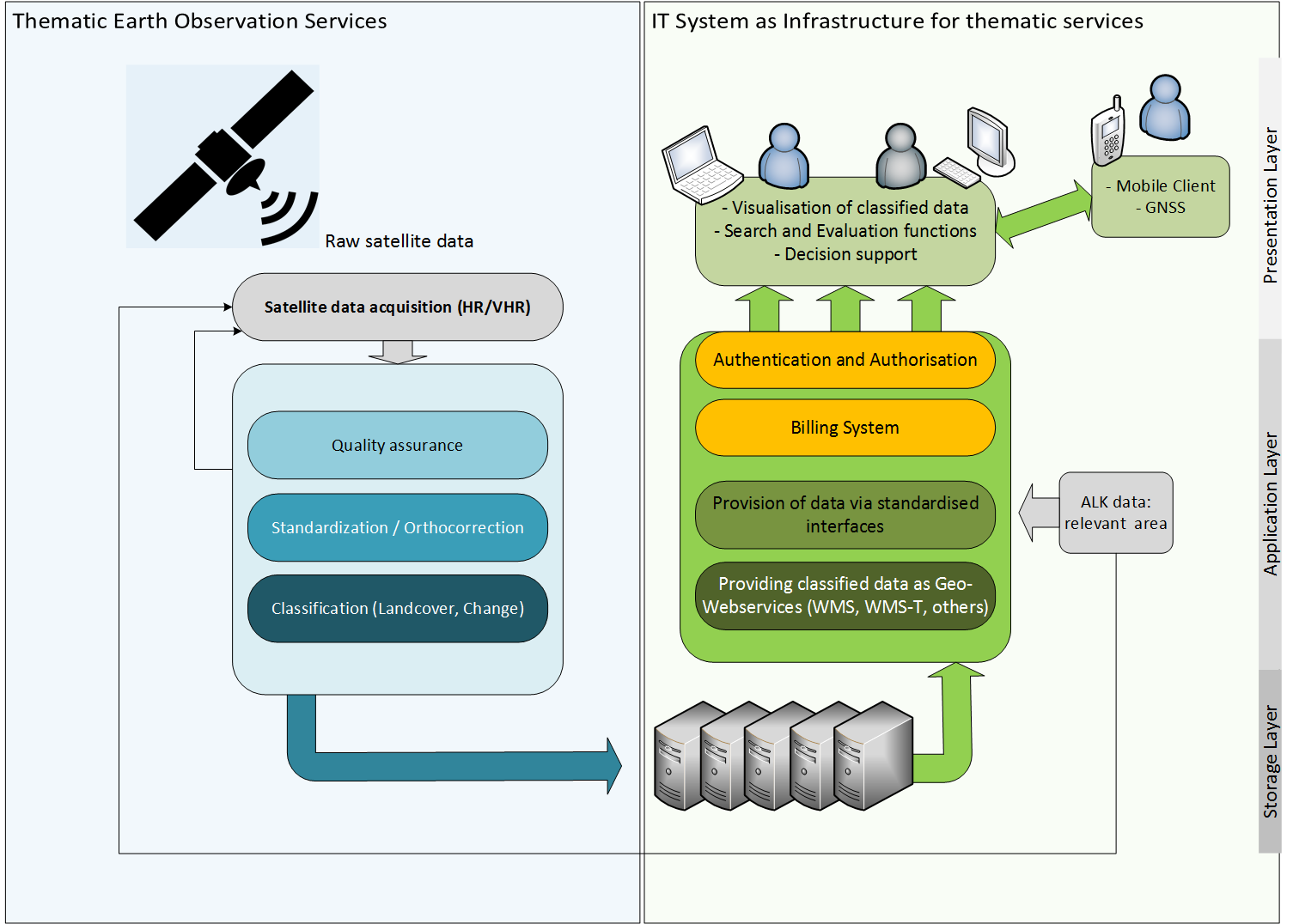
Figure 1: High-level block diagram of the system / service
The system includes two main subsystems.
Thematic Earth Observation Services
Thematic Earth Observation (EO) services (Figure 1, left side) are defined by data (pre-) processing steps, the derivation of biophysical variables and indices and the thematic image classification. A very important aspect in advance is the selection of appropriate satellite data. Additionally, auxiliary data and in-situ data are useful for the subsequent validation steps. Selection of the satellite data is followed by different image processing steps and quality checks.
The following thematic EO-based services will be provided for the demonstrator:
- Continuous Forest Status Information Service
- Afforestation Mapping Service
- Deforestation and Forest Degradation Mapping Service
IT System for Dissemination
For dissemination of the thematic services, a dedicated IT system will be developed. It consists of the following main components (Figure 1, right side):
- Storage Layer
- Application Layer
- Presentation Layer: Static Client
- Presentation Layer: Mobile Client (using GNSS)
Space Added Value
Satellite-based Earth Observation
Earth Observation is the key space asset for the solution, as satellite images allow for a precise thematic classification and change detection. Data from the Copernicus Sentinel satellites provided by the European Space Agency (ESA) is used.
Satellite Navigation
The Global Navigation Satellite System (GNSS) is used to support in-situ assessments. The mobile client uses GNSS for two purposes. One is the localisation of previously detected changes in the forest or areas of interest. Conversely, if the assessment starts in the field, the assessor can use the GNSS component for geo-referencing areas of interest.
Within the proposed system, exact positioning is required. There is no real alternative for GNSS as manual localisation would not be precise enough.
Current Status
The implementation phase of the FAMOS system is finished, where automated processing chains are developed, allowing for a high grade of automation when analysing satellite images.
Outcome:
The services aim to fill missing gaps in monitoring and providing transparency within the cocoa supply chain from the smallholder farm to the end customer were developed:
- Forest Landscape Information Service,
- Plantation/Afforestation Mapping Service,
- Deforestation and Forest Degradation Mapping Service.
The system is ready for further commercial use.
