
Objectives of the service
Scottish salmon farming, a £800 million industry, faces increasing environmental challenges, including harmful algal blooms (HABs), rising sea temperatures, and low oxygen levels, leading to 20% annual fish stock losses. Current monitoring methods rely on buoys and manual surveys, which are costly, time-consuming, and lack regional coverage.
SeaSat’s Ocean Sentinel Health Index (OSHI) provides real-time environmental monitoring using satellite data and machine learning to deliver accurate, high-resolution coastal condition insights. The project will:
-
Monitor real-time environmental changes (temperature, salinity, HAB risk).
-
Provide early warnings to enable proactive management.
-
Improve decision-making with an interactive dashboard.
This study will validate both the technical feasibility and commercial potential through pilot trials in selected farm locations, ensuring data accuracy, customer validation, and commercial readiness.
Users and their needs
Our primary users are Scottish salmon farmers, with future expansion to the wider aquaculture sector. They need accurate, real-time monitoring to reduce fish mortality and comply with sustainability regulations.
Key User Needs & Challenges:
-
Salmon Farmers (Scotland, EU, North America) – Need real-time data on sea temperature, salinity, and algal blooms. Current monitoring is limited, expensive, and lacks broad coverage.
-
Fisheries & Marine Conservation Agencies – Require coastal ecosystem health data to assess environmental impacts.
-
Government & Regulatory Bodies – Need data-driven insights for policy enforcement and compliance monitoring.
Target Countries: Scotland, UK, Norway, Canada, Chile, Ireland
The main challenge is proving data accuracy and cost-effectiveness. To address this, we will pilot OSHI with Scottish salmon farms, ensuring validation before wider adoption.
Service/ system concept
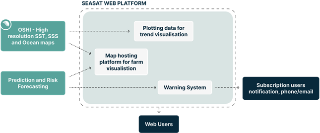
SeaSat’s OSHI platform provides an interactive dashboard where users can:
-
Monitor real-time coastal conditions (temperature, salinity, HAB risk).
-
Receive predictive alerts for environmental risks.
-
Analyse historical trends for better decision-making.
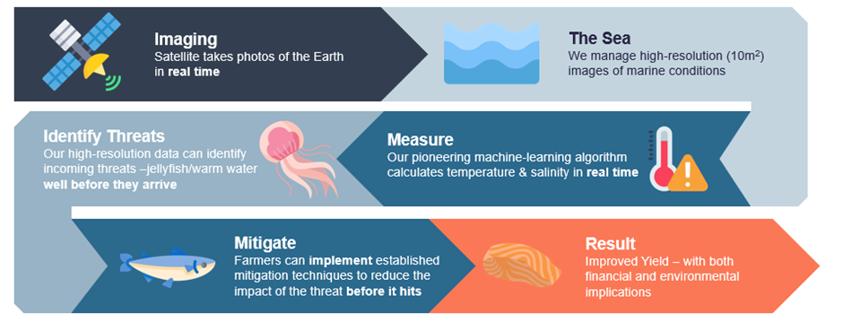
Processing chain
-
Satellite Data Collection – Gathering optical (Sentinel-2, Sentinel-3) and radar (Sentinel-1) imagery.
-
Machine Learning Processing – AI models detect ocean colour, temperature anomalies, and algal bloom risks.
-
Dashboard Integration – Users access maps, forecasts, and alerts via our cloud-based platform.
A pilot study with Scottish salmon farms will validate the platform’s accuracy, usability, and commercial viability before scaling.
Space Added Value
OSHI integrates multiple space assets to provide superior monitoring capabilities over traditional methods.
-
Sentinel-1 Radar – Captures ocean surface mixing and currents, working in all weather conditions.
-
Sentinel-2 & Sentinel-3 Multispectral Imaging – Tracks sea surface temperature, chlorophyll-a (HAB indicator), and turbidity at 10m resolution, compared to 1km for conventional sensors.
-
Advantages over traditional monitoring:
-
Scalability – Monitors entire coastlines in one scan, unlike point-based sensors.
-
Cost-Efficiency – Eliminates manual sampling and maintenance costs.
-
Predictive Power – AI forecasting provides early warning alerts, reducing financial losses.
-
Using medium resolution S1 and S2 satellites enables coastal oceans to be observed without the land adjacency and pixel interference from traditional ocean monitoring satellites
By combining Earth observation, AI, and cloud computing, OSHI delivers scalable, cost-effective solutions for sustainable aquaculture and marine ecosystem monitoring.
Current Status
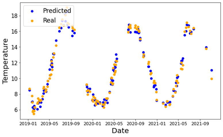
Satellite predictions compared to readings from a physical sensor.
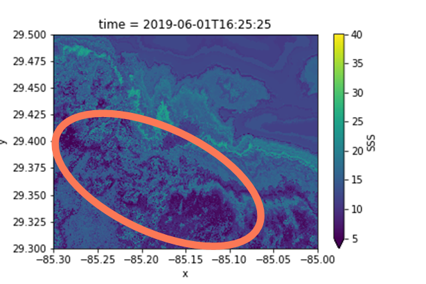
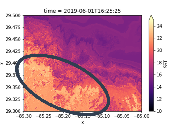
Images successfully identified warm and nutrient rich conditions which led to an Algal bloom event 2 days later.
Held a presentation at the UK Aquaculture Awards 2025, engaging salmon-farm managers in focused discussions on environmental monitoring needs. Completed a one-month pilot at Loch Fyne in May, during which our platform predicted sea-surface temperature within ±0.5 °C, salinity within ±0.2 PSU, and issued an algal-bloom alert four days before the observed event. Currently finalising data-integration with Glasgow University’s School of Geographical and Earth Sciences and drafting pilot protocols with two upcoming projects for salmon and seaweed commercial farms.