Objectives of the service
SkyLiberty is a service delivered by ESNAH, which aims to offer a safer and easier flight experience for pilots, while also making them more effective.
ESNAH’s vision is based on reliable connectivity links between aviation stakeholders (e.g. Pilots, Air Traffic Control, Weather information providers, flying schools, maintenance centres) allowing an easy, reliable, secure and cheap access to information to everyone at any time of a flight.
To implement this vision, ESNAH provides pilots and aircrafts operators with a Software as a Service solution (Apps & Web app) coupled with a smart tracking device.
Users and their needs
The SkyLiberty service users belong to 3 main categories, which have the following respective needs:
Pilots
- Communication with operator and ATC
- Provision of real-time aeronautical information during flight
- Provision of real-time status of the aircraft before arriving at the airport
- Provision of a satellite phone access during flight
Air Training Organisations (ATO)
- Notification of abnormal aircraft procedure during flight
- Monitoring of aircraft on the ground
- Sharing information concerning aircraft real time status with all qualified pilot (Defect report, aircraft status, flight log)
- 2-way communication with pilot in real-time
- Notification if an aircraft makes an airspace infringement
- Implementation of a virtual black box on the aircraft
- Need to have pilots paying their flights more rapidly
Air Traffic Control (ATC)
- Improvement of communication with general aviation aircraft in airspace without authorization, with incorrect frequency or radio failure in order to reduce airspace infringement and improve safety
- Monitoring the greatest possible amount of vehicles presenting a possible collision risks during aviation operations
All of the aviation aid systems currently on the market only deal with one aspect of the flight (for instance a logbook, a navigator,…) and there is not yet a comprehensive tool, which can be affordable for everyone. ESNAH has therefore decided to create a single product that meets both the needs of operators, pilots and airplanes operations.
While SkyLiberty will be initially deployed in Europe, the service ambitions to acquire in the longer term an international customers portfolio.
Service/ system concept
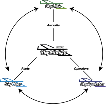
SkyLiberty is based on 3 main building blocks, working either separately or together, hence offering a higher added-value to the users.
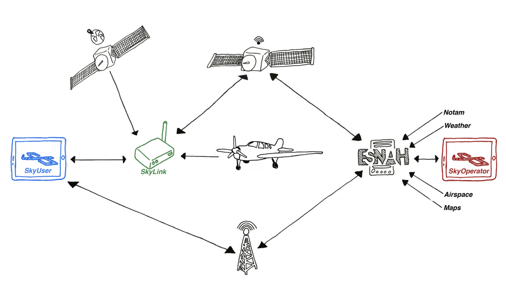
SkyLink is the cellular/satellite gateway connected if possible with the aircraft avionics and usable by
- operators to track, record/analyse flight and exchange message via SkyOperator
- pilots to retrieve aeronautical information and exchange messages via SkyUser or via the screen of SkyLink
- air traffic control to send urgent messages to pilots with acknowledgement features.
SkyOperator is the management platform of the operator to
- manage, track and anticipate maintenance of an aircraft
- manage members and student pilots
- improve safety and reduce airspace infringement
SkyUser is an application (mobile and web) for pilots allowing to:
- exchange information during flight
- be connected with an operator to book an aircraft and be aware about aircraft real time status
- communicate with air traffic control and aircraft operator. On the ground, it can use Wi-Fi or cellular. During flight, it can connect to SkyLink to exchange information through cellular or satellite network.
- access a VFR/IFR navigator including all recommendations of aeronautical safety, in order to:
- improve flight preparation and knowledge of aircraft defect report
- retrieve all the necessary information in real time during the flight
- reduce the number of air space infringements
- decrease fuel consumption through optimal routing
Space Added Value
SkyLiberty requires a high accuracy geolocation system. GNSS data is used for avoiding the airspace infringement, detect runway incursion, provide a reliable real time following flight and can be used in high-precision navigation competitions.
Moreover, above 2000 feet (600m), the GPRS network is not available for pilots who can therefore no longer obtain real-time data during the flight via phone networks. SkyLiberty offers therefore to use satellite communication (Iridium) to allow internet connection and share real-time information according to the services proposed.
Weather satellite imagery provides pilots with a clear visualisation of the enroute weather, which is the most dangerous environmental factor during the flight.
Current Status
The Final Review meeting was held on 02 March 2020 and was considered successful. Thanks to this contract extension, ESNAH had the opportunity to add new features to the SkyLiberty service to better fulfil the needs of users. These modifications include:
- improvement of the internal functionalities of SkyLink tracking device
- connectivity to the aircraft avionic bus
- implementation of message exchanges with acknowledgment of receipt
- better encryption
- development of a navigator functionality
This work carried out under this activity has enabled ESNAH to obtain a marketable version of these products, which was unanimously welcome by a number of users such as special airborne operations, Air freight, aircraft manufacturer, flying academy and aircraft renting operators. ESNAH has been in contact for a few months with several of these stakeholders, who all confirmed that the proposed solution would allow them to improve their operations but also the pilot’s safety. In the coming months, ESNAH's challenge is to consolidate a number of partnerships and sign contracts with major operators.

Prime Contractor(s)