Objectives of the service
In Accordance with Article 7 of the EU Energy Efficiency Directive, countries within the EU should take active steps to implement an energy efficiency obligation scheme to reduce energy consumption through energy efficiency measures.
The binding target for the UK government is to reduce energy consumption by 324 TWh by the end of 2023. More than 60% of these energy savings are planned to be achieved through energy savings in the domestic sector. To this end, the Energy Company Obligation (ECO) programme, designed to reduce the energy consumption in the domestic sector, is strategically important to deliver the legally binding savings. The largest UK energy supply companies are the obliged ones to deliver the relevant energy savings through energy efficiency measures to UK households. Failure to deliver the measures in the allocated time results in harsh redressment payments and fines for the energy supply companies.
The irregular nature of installation works increases the risk of failing the ECO targets. The optimal process of installing ECO efficiency measures should begin with the most thermally inefficient buildings, however, currently this information is not available, resulting in cost intensive blanket targeting of random households. Alleviating this excessive waste of time and human resources requires prior knowledge of the buildings of poorest thermal performance, enabling assessors to navigate the building stock more effectively and install insulation measures in the areas of greatest benefit. Such prior knowledge could potentially reduce the cost for location of opportunities for ECO installations by 66%, and avoid severe penalties for missed installation targets
Users and their needs
The current issue facing obliged energy companies is the non-existence/accessibility and low quality of information regarding thermally problematic building stock. A need for advanced knowledge of the extent and specific energy efficiency problems in any given area has been identified.
Following customer’s needs have been formulated:
- Advanced knowledge about the extent of building energy inefficiency problems in any given area.
- Knowledge about thermally inefficient properties, locating specific energy efficiency problems (leaky windows, uninsulated walls and lofts).
Offered Services:
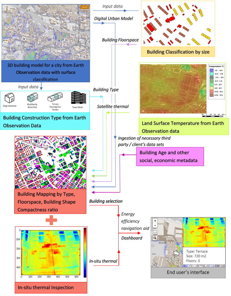
ThermCERT enables following services (illustrated in the Figure 1):
- Design of 3D model of the city with classification of land surface materials;
- Automatic building classification by floor space area;
- Determination of urban heat islands and areas of intensive thermal energy emissions;
- Semi-automatic building classification by the construction type;
- Determination of building shape compactness ratio;
- In-situ thermal imaging to visualize energy leakage from homes, locate main thermal bridges observable from the street for home improvements.

Service/ system concept
System enabling the Services
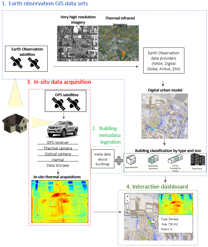
The ThermCERT system architecture consists of four main components:
- Earth Observation GIS data sets: [e.g. Earth observation data acquisition, data processing, data fusion, derivation of individual output products],
- Building meta-data ingestion, completing the understanding about building specifics, social, demographical compositions of the households, enabling for advanced building analysis for the client,
- In-situ data acquisition enables for detailed analysis of the building thermal performance and potentially identify energy efficiency issues (leaky windows, doors, dampness, thermal leaks, insufficient wall and loft insulation),
- Interactive dashboard: The result of the combination of the information, resulting from the above three data modules, is displayed on the ThermCERT dashboard interface. This is where the end-users interact with the ThermCERT services, and gain the enhanced situation awareness about their areas of interest.
An overview of the ThermCERT system concept is illustrated in the Figure 2.

Space Added Value
The space assets to be used for this project can be broken down into two distinct sections:
- Earth Observation
Acquisition of VHR optical, multispectral and potentially thermal infrared data are required from Earth Observation scans for ThermCERT to function. This data is key for building the wide area data sets of the urban environment which allow the energy assessors to down-select the properties of highest interest, to which the thermal scanning vehicle can be dispatched. The parameters like building floor space and built type are derived from the stereoscopic 3D model of urban elements (buildings). The 3D building objects are made from severalVHR (<1 m resolution) satellite images (from WorldView 1/WorldView 2/WorldView3/ Pleides-1A/1B satellites).
- GNSS
GNSS signal data is required to geotag all thermal images taken from the in-situ vehicular scans. The GPS positioning will be enhanced with an aid of inertial measurement system, allowing for the data collected from the mobile platform to be geo-referenced with accuracy of less than 1m. By geo-referencing the images as they are created, Astrosat will be able to link these images to the Earth Observation satellite data sets mentioned above.
Current Status
The feasibility study was started in October 2015, and concluded in February 2017. Both the technical and business aspects of the project were evaluated positively and the outcome of this study is a concrete basis for further work.
Prime Contractor(s)
Subcontractor(s)


