Objectives of the service
General Aviation pilots and aeroclub managers face growing challenges in complying with new U-space regulations, ensuring flight safety in airspaces shared with drones, and maintaining accurate operational records. Current processes are fragmented, often paper-based, and lack interoperability, increasing workload and risk.
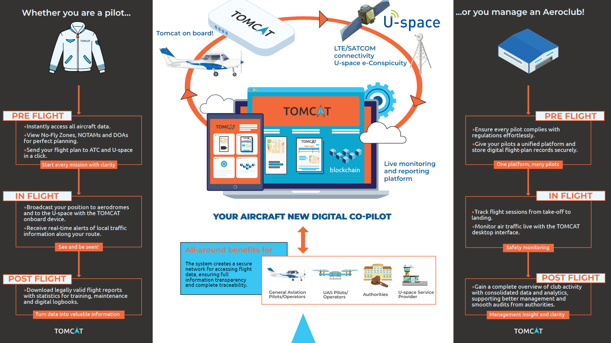
TOMCAT provides a turnkey digital solution covering all flight phases:
-
Pre-flight: Digital planning and automated submission of flight plans to authorities and U-space Service Providers.
-
In-flight: Enhanced situational awareness through electronic visibility (i-Conspicuity) and real-time traffic information for manned and unmanned aircraft, supported by dual connectivity (LTE and satellite).
-
Post-flight: Certified digital logbooks and flight reports for legal protection and training.
The system combines a portable Electronic Flight Bag device (Pollicino™ GA), a secure cloud portal, and a blockchain-based certification service. It leverages authenticated satellite navigation, Earth Observation data for altitude harmonization, and satellite communications for global coverage.
The project aims to develop, integrate, and validate this solution through a pilot campaign with aeroclubs, demonstrating its ability to improve safety, simplify compliance, and accelerate the digitalization of General Aviation operations.
Users and their needs
The TOMCAT solution targets General Aviation pilots and aeroclub managers involved in sport, leisure, and training flights. These users operate in low-level and U-space airspaces where compliance with new regulations and safe integration with drone traffic are critical.
User Needs:
-
Digital flight planning and submission to authorities and U-space Service Providers.
-
Real-time traffic awareness for manned and unmanned aircraft to improve safety.
-
Compliance with electronic conspicuity regulations without costly infrastructure.
-
Certified digital logbooks and flight reports for legal protection and training.
-
Fleet management tools for aeroclubs, including guest pilot coordination.
Challenges:
-
Ensuring interoperability with U-space systems and regulatory frameworks.
-
Providing reliable connectivity in areas with limited terrestrial coverage.
-
Delivering an user-friendly solution that meets both technical and legal requirements.
Countries of target users: Italy (pilot phase), scalable to other EU countries
Service/ system concept
TOMCAT gives pilots and aeroclub managers a complete digital toolkit for safer and more efficient flight operations. Users can plan flights online, check airspace restrictions, and submit flight plans directly to authorities. During the flight, the system provides real-time traffic awareness, showing nearby aircraft and drones to improve safety. After landing, pilots can download certified flight reports and logbooks, useful for training and legal compliance.
The system works through three main components:
-
Pollicino™ GA device: A small portable box installed in the cockpit. It tracks the aircraft using satellite navigation and sends data via mobile or satellite networks.
-
TOMCAT Portal: A web and mobile platform where pilots and managers plan flights, monitor operations, and access reports.
-
Device Gateway: A secure service that validates flight data and stores it on a blockchain for legal protection.
Together, these components ensure continuous connectivity, even in remote areas, and provide trusted information for safer flying.
Space Added Value
TOMCAT combines three space assets to deliver trusted, continuous, and legally valid flight services:
-
Satellite Navigation (Galileo OSNMA): Provides authenticated positioning data, ensuring integrity from the source. This enables services such as Authenticated Tracking and certified flight reports, which are impossible with standard GNSS solutions vulnerable to spoofing.
-
Earth Observation (Digital Terrain and Elevation Models): Supplies terrain data for risk mapping and altitude harmonization through the Common Altitude Reference service. This ensures that both manned aircraft and drones share a consistent altitude reference, reducing collision risks in low-level airspace.
-
Satellite Communications: Offers global connectivity as a backup to terrestrial LTE, guaranteeing service continuity even in remote areas or above U-space limits. This dual-channel approach ensures pilots always remain electronically visible and compliant with regulations.
By integrating these assets, TOMCAT provides an innovative solution delivering a unique combination of safety, compliance, and legal trust for General Aviation operations.
Current Status
The Critical Design Review (CDR) was successfully completed in March 2026. Current activities focus on hardware integration, interface consolidation, and preparation for the Factory Acceptance Tests (FAT) that is expected by summer 2026. The verification will involve progressive activities in laboratory, simulation, and controlled airfield environments, with pilot involvement supporting usability validation.