
FUNDING OPPORTUNITY
Healthcare systems in developing economies and health ecosystems continue to face considerable challenges in providing high quality and affordable care.


Why is that? Does that mean we are losing potential entrepreneurs somewhere along the road to adulthood? And what can we learn from this, both in the way we bring up children and how we support potential entrepreneurs as they enter the world of business?
Many of the features that distinguish entrepreneurs from the rest of us mirror the differences between children and adults. For a start, just like entrepreneurs, children are naturally curious – they’re fascinated with everything and won’t be fobbed off with a simple answer. Instead, they’ll keep asking questions and pushing to find out more. And they combine this love of exploration with fantasy that enables them to imagine novel ideas and solutions where adults typically do not.
Unlike most adults, children are not obsessed with time and timespans and routine. They don’t rush through life completing everything in a linear fashion and they don’t put boundaries around what they can achieve by considering how long they have to complete it. When they’re absorbed in something creative, such as building a castle out of Lego or Minecraft, nothing else matters. And when they start a game, they don’t plan everything ahead – instead, they’re happy to simply see what happens.
That’s because children don’t mind making mistakes. What they do fear is being made to feel bad for making mistakes through being chastised by parents or teachers. Instead, they want our trust and forgiveness. And when you give someone that, they will perform better next time.
There’s a saying that “The person who never makes a mistake will never make anything”. Children learn a lot from failure, whether it’s a house of wooden blocks toppling over or falling off their bicycle or skateboard. Ever wondered why kids are so quick at learning how to ski? It’s because they aren’t afraid to fail – they simply get up and try again, because they can see the exciting opportunity ahead.
This combination of innate curiosity, exploration and focussed pursuit of a dream is also what we find in entrepreneurs but few adults retain this from childhood. I believe that’s because we are trained out of this approach through the way we are taught at school and the way our exam systems work, which doesn’t teach us to seek out alternative paths or solutions. Although that changes at university, where students are encouraged to take a more creative approach, by then for many it is too late. Adults also tend to exploit rather than explore, in that they seek to make existing things quicker, faster and lighter. But without exploration alongside exploitation, nothing truly new emerges.
Kids are amazing! Everyone that has one knows this. I am father of twins, Lucas and Johannes and they remind me every day what connecting curiosity and fantasy means. We need to allow potential entrepreneurs to do this too – to see solutions where other people do not and to create products where others don’t expect something to emerge. I think this is something we all have inside us, but we need to find our own way to let it happen. In the meantime, we need to foster it in others – just as parents can encourage it in their children – whether they are in our own businesses or in the businesses we support through schemes such as incubation.
Simply providing money is not enough. We also need to provide a nurturing environment that allows mistakes to happen, with space for creativity and exploration. This has always been our approach through ESA Space Solutions and our incubation programme, where we look at the people applying, not just at the solutions they are proposing to develop. There are no KPIs for creativity and curiosity, but in the same way as with children, entrepreneurs need to continue to be curious and creative, as this is where truly revolutionary new services and products will come from.
Frank M. Salzgeber, Head of Innovation and Ventures Office, ESA
ESA Space Solutions is the go-to-place for great business ideas involving space in all areas of society and economy. Our mission is to support entrepreneurs in Europe in the development of business using satellite applications and space technology to improve everyday life. Our programme is designed to provide multiple entry points such as ESA Business Incubation Centres (ESA BICs), ESA Technology Broker Network, and ESA Business Applications programme. Funding typically ranges from 50KEuro to 2MEuro and supports everything from space technology transfer, early stage incubation programs, Feasibility Studies to large-scale Demonstration Projects.
Healthcare systems in developing economies and health ecosystems continue to face considerable challenges in providing high quality and affordable care.
There will be two deadlines at which point proposals will be assessed and feedback provided:
1st Intake: 15 June 2021
2nd Intake: 15 September 2021
In the upcoming Announcement of Opportunity economic operators are invited to propose a Demonstration Project addressing the theme of:
Space for Smart and Uncrewed Shipping:
downstream services enabled by 5G and advanced positioning, navigation and timing (PNT)
March, 23 / 2021
Five companies from three ESA Business Incubation Centres (ESA BICs) were invited to have a presence at the ESA Space Solutions stand for INTERGEO 2020 in order to raise the profile of their businesses. In addition, five experts from ESA gave talks and interviews, including Nick Appleyard, Head of ESA Space Solutions, and Frank Salzgeber, Head of Innovation and Ventures Office, ESA.
The participating ESA BIC incubates were Drone Harmony and Fixposition from ESA BIC Switzerland, Precision Navigation Systems from ESA BIC Estonia, and ThingsOnAir and Vaireco from ESA BIC Hessen & Baden-Württemberg.
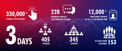
Over 1,200 participants visited the ESA Space Solutions digital stand, including the stands of the five ESA BIC start-ups – that’s 10 per cent of all participants.The success of the show can be seen in the numbers. Over three days at INTERGEO Digital, there were over 330,000 interactions at digital touchpoints. Around 12,000 participants from 153 countries each created a digital profile and viewed information on the exhibitors' pages, as well as convening via the video meeting rooms. INTERGEO Digital has never been as international as this year, showing that even in these difficult times, people are happy to embrace innovative new formats for events.
Martin Fuchsberger from Drone Harmony summarised the benefits of the shared ESA Space Solutions booth as “higher presence, credibility and visibility at a lower cost”, adding that “we benefited not only from a subsidised exhibition presence but also from the additional traction and visibility that the ESA BIC marketing generated.”
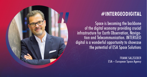
“Space is becoming the backbone of the digital economy, providing crucial infrastructure for Earth observation, navigation and telecommunications,” said Frank Salzgeber. “INTERGEO Digital was a wonderful opportunity to showcase the potential of ESA Space Solutions.”
ESA Space Solutions stand welcomes high-ranking experts from ESA
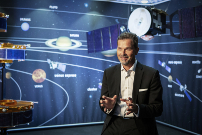
Frank Salzgeber was physically present at the INTERGEO Expo Lounge stage where he gave an interview. This broadcast was shown three times over the three days, with over 200 visitors stopping by to have a look. He also gave a presentation via the ESA Space Solutions stage from the new studio at Cesah (ESA BIC Hessen & Baden-Württemberg). The interview with Nick Appleyard was also livestreamed via the INTERGEO Expo Lounge Stage and attracted many visitors.

The ESA BIC incubated company Precision Navigation Systems gave a pitch during INTERGEO Digital in their digital meeting room, while Drone Harmony offered a live demo on
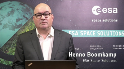
their sub-stand. Fixposition pitched on the EXPO stage. Henno Boomkamp (ESA Tech Transfer), Donata Pedrazzani (ESA BIC network) and Davide Coppola (ESA Space Solutions) completed the list of talks from ESA experts.
INTERGEO is the biggest trade show in the field of geoinformation; this is an area many ESA BIC start-ups are working in and therefore a perfect fit for ESA Space Solutions. Both the start-ups and Cesah (ESA BIC Hessen & Baden-Württemberg) are looking forward to attending the trade show again in 2021.
ESA Space Solutions is the go-to-place for great business ideas involving space in all areas of society and economy. Our mission is to support entrepreneurs in Europe in the development of business using satellite applications and space technology to improve everyday life. Our programme is designed to provide multiple entry points such as ESA Business Incubation Centres (ESA BICs), ESA Technology Broker Network, and ESA Business Applications programme. Funding typically ranges from 50KEuro to 2MEuro and supports everything from space technology transfer, early stage incubation programs, Feasibility Studies to large-scale Demonstration Projects.
Via San Martino 12
20122 Milan
Italy
Piazzale Aldo Moro, 7
00185 Roma
Italy
Viale John Fitzgerald Kennedy, 112
80125 Napoli
Italy