Earlier this month, ESA joined global leaders, innovators and policy makers at the Smart City Expo World Congress in Barcelona, Spain, one of the most significant global events about urban innovation and sustainability, to promote the role space can play in the development of Smart Cities. At the event, experts representing ESA showcased a selection of its high-impact projects developed as part of the Business Applications and Space Solutions (BASS) programme, demonstrating ESA’s commitment to addressing critical urban and environmental challenges harnessing space technology.
Urban centres face mounting environmental, social, and infrastructure pressures, and space technologies offer unique solutions to these complex issues. Through the BASS programme, ESA is playing a crucial role in developing technologies that enhance city resilience, environmental sustainability, and data-driven planning. Initiatives from ESA’s Smart and Green Cities Task Force are dedicated to solving challenges such as air quality monitoring, energy efficiency, and climate resilience, ensuring cities can effectively adapt to evolving needs.
Satellite technology provides valuable support in urban planning and infrastructure management. Space-derived data can map urban heat islands, assess air quality, monitor green spaces, and track city-wide energy consumption patterns. These insights enable smarter, quicker decision-making for urban planners and policymakers, promoting sustainable city growth.
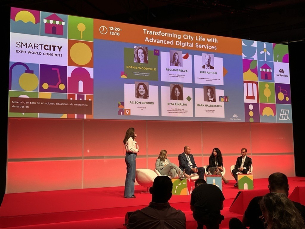
At the event, Rita Rinaldo, ESA’s Head of Applications Projects & Studies Division, joined an expert panel on 'Transforming City Life with Advanced Digital Services,' highlighting how space data and technologies can address smart city challenges, strengthen business propositions, and drive cross-sector innovation for large-scale adoption. She also outlined ESA initiatives aimed at urban sustainability, connectivity, and liveability. Similarly, ESA’s Senior Sustainability Applications Officer, Beatrice Barresi, presented 'How Space Solutions Can Support Smart and Green Cities,' showcasing sustainable solutions—both environmental and economic—that benefit city officials and communities. Addressing transport, energy, and infrastructure challenges, these services create economic value for developers while promoting environmental sustainability and supporting cities' green transition goals.
During the event, ESA also showcased some of its high-impact projects on its stand, including Airmine, which uses satellite data to monitor air quality and deliver real-time, hyper-local pollution data. Airmine’s innovative approach addresses a crucial need in modern cities, where air quality affects millions daily, empowering both citizens and policymakers to make informed choices. Such projects demonstrate ESA’s broad support for solutions that tackle urban challenges, including public health, climate resilience, and biodiversity preservation.
Reflecting on the event, Rita Rinaldo said “Participating at Smart Cities Expo has been inspiring and fruitful, featuring conversations and exchanges with municipalities representatives, technology providers and space sector players, all engaged in addressing the needs of smart cities. We have promoted the unique value that space contributes to addressing challenges faced by cities today as well as those anticipated in the future. This is why we have initiated the Space for Smart and Green Cities Task Force, bringing together city representatives and sector associations, to connect space and non-space ecosystems and drive future initiatives.”

Inspiring future generations is an important element of ESA’s mission to foster sustainable urban development and as part of SCEWC, ESA hosted a group of 50 local schoolchildren, between the ages of 9-11, for an interactive learning experience. Through engaging, hands-on activities, ESA aimed to spark curiosity about the role of space technology in addressing urban challenges and to inspire young minds to think creatively about building a more sustainable world.
ESA’s active participation in the Smart City Expo World Congress, is part of its commitment to smarter, greener cities that prioritise sustainability, inclusivity, and resilience. This vision will continue to drive its Smart and Green Cities initiatives and collaborative projects long after the event and ensure ESA remains at the forefront of sustainable urban development, by pioneering innovative uses of space technology to transform the cities of tomorrow.
Posted to Hero article section
Posted to Hero article section