Edge Intelligence refers to a paradigm shift in computing in which certain data analysis processes are moved from centralised cloud or in-house data centers to the “edge” of the network. In such solutions, certain aspects of the analysis of the data and derivation and communication of insights, takes place at the site where the data is generated. The benefits of this are many and can be exploited in several settings and thematic domains, fitting into a broader distributed computing model that enables higher performing systems
Thanks to a partnership with the European Space Agency (ESA), QuantCube Technology is now using satellite-derived data to provide financial institutions with additional real-time insights into macroeconomic trends.
With ESA’s guidance and funding, QuantCube has incorporated new indicators of global development, food production and weather trends into its Macroeconomic Intelligence Platform. Used by asset management firms, hedge funds, pension funds and investment banks, the QuantCube platform provides real-time indicators for global trade, inflation, tourism and other key macroeconomic variables.
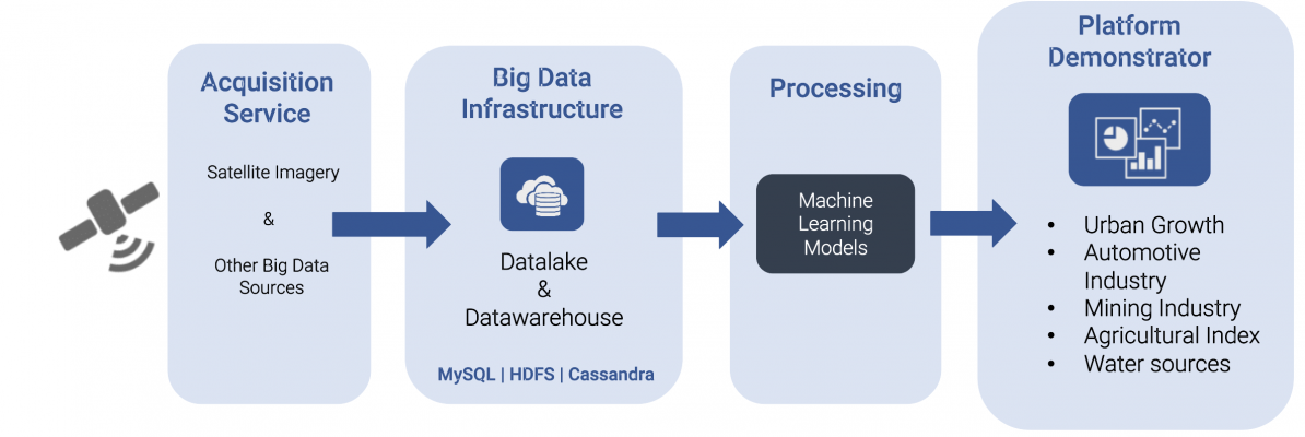
In a two-year demonstration project, ESA supported QuantCube in harnessing data from the EU Copernicus Programme’s Sentinel-2 and Sentinel-5P satellites. With QuantCube already operating one of the largest data lakes in the world – processing more than 14 billion data end points – the addition of satellite data is very powerful. As a result, using artificial intelligence and big data analytics, QuantCube is able to provide an excellent view of economic changes and deliver real-time insights in granular detail at regional and country level.
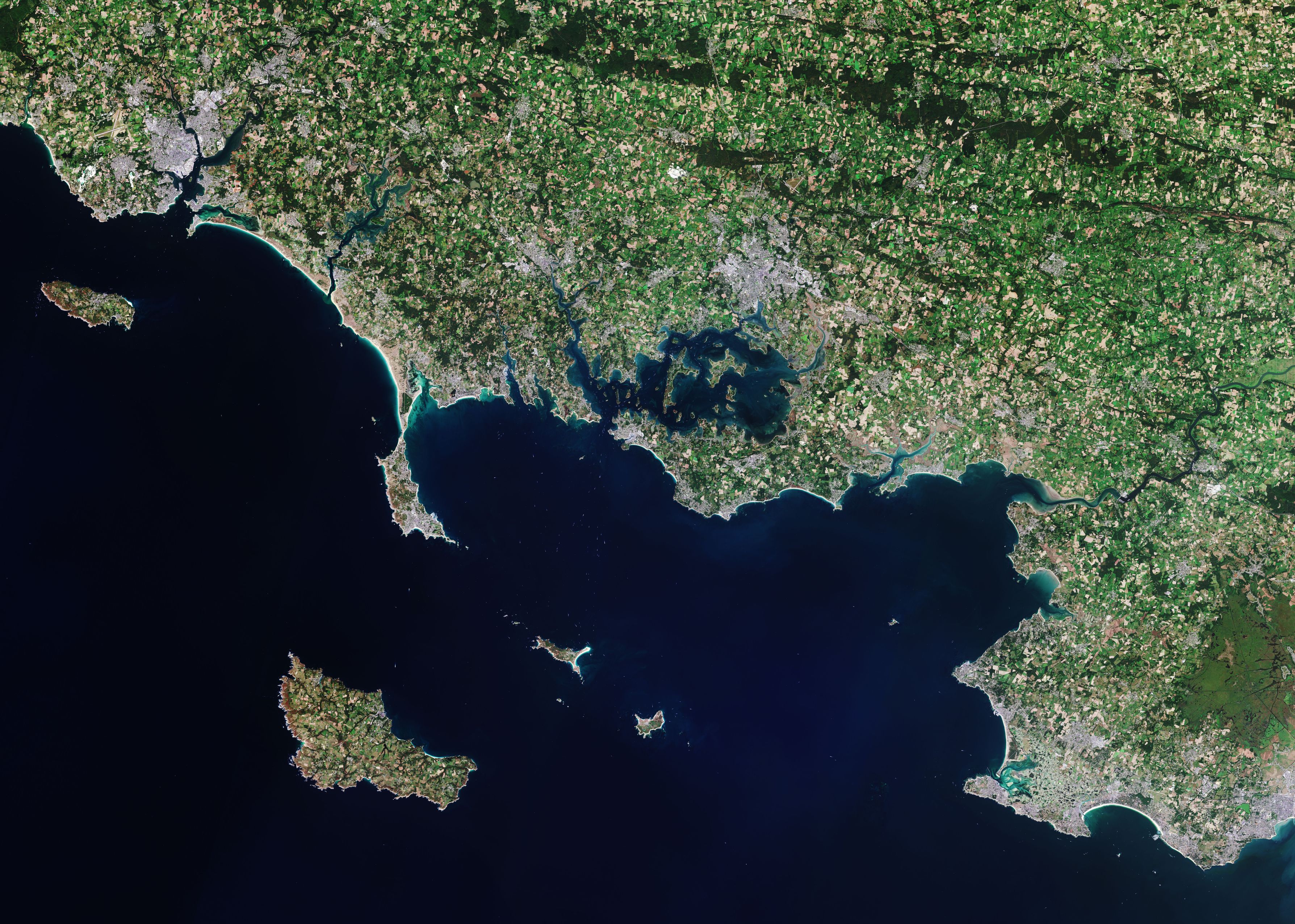
The Copernicus Sentinel-2 mission takes us over Morbihan – a French department in the south of Brittany. Credit: Contains modified Copernicus Sentinel data (2020), processed by ESA, CC BY-SA 3.0 IGO
Space-enabled monitoring
The four new indicators enhancing QuantCube’s Macroeconomic Intelligence Platform are:
Urban growth – using optical images from Sentinel-2 to track urbanisation and development of cities over time.
Human activity – combining meteorological data and atmospheric monitoring from Sentinel-5P, specifically nitrogen dioxide levels, to measure and compare human activity.
Water stress – using Sentinel-2 images to identify fluctuations in surface water and assess the likelihood of drought.
Agricultural yield – using images from Sentinel-2 of agricultural land use, in combination with meteorological data, to help predict changes in yields.
“Working closely with ESA on this demonstration project, we have applied artificial intelligence and deep learning techniques to ESA’s Earth observation data. Combining this with additional QuantCube data sources – including news and social media data, industry and employment data, international trade and shipping data, meteorological and oceanographic data, and more – has allowed us to create a ground-breaking new set of economic indicators,” said Thanh-Long Huynh, Chief Executive of QuantCube, based in France.
Volker Schumacher, Business Applications Engineer at ESA, said: “ESA has guided the QuantCube team through its Business Applications programme in a demonstration project over the past two years and helped to co-fund the firm’s service development into the best way of incorporating Earth observation data, for instance from the Sentinel satellites, within its real-time economic indicators."
“We’re very happy that QuantCube is now launching these four new global satellite indicators to market and that financial institutions and other organisations will be able to benefit from this new real-time economic intelligence.”
Thanks to a partnership with the European Space Agency (ESA), QuantCube Technology is now using satellite-derived data to provide financial institutions with additional real-time insights into macroeconomic trends.
A Belgian start-up company, supported by ESA Space Solutions, is researching ways to use satellite imagery to help increase the amount of carbon held in soil, in turn significantly reducing the effects of climate change wrought by agriculture. ScanWorld will use the data gathered to help the new breed of carbon farmers speed up the process of soil sampling, reducing their costs and increasing carbon capture.
Conventional farming is under scrutiny. Practices such as widespread use of fertilisers, monocultures and leaving soil bare in winter damage ecosystems and drive climate change. Vegetation is also under pressure from extreme weather events, soil erosion and the constant potential for new diseases to emerge. Meanwhile, the growth in world population is putting further strain on agriculture – by 2050 it is estimated that 60 per cent more food will be required to feed the world, yet simultaneously crop yields will be decreasing under pressure from global warming. This has led to the rise of new forms of sustainable agriculture, a subject discussed in depth at the recent COP26 climate summit in Glasgow.
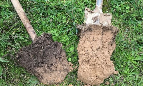
A soil sample with a darker top layer, indicating a high carbon content (left), compared to a soil sample with lower SOC content (right). Copyright: Soil Capital Farming (www.soilcapitalfarming.ag)
One technique is carbon farming which aims to increase the amount of carbon in soils, and one which Belgian start-up ScanWorld intends to make much less onerous from now on. Atmospheric carbon is a well-understood cause of climate change. The good news is that soils can store up to three times more carbon than the atmosphere and increasing soil organic carbon (SOC) also improves the health and resilience of ecosystems, and protects against both drought and flooding. This realisation is now driving changes in agricultural practices as numerous initiatives from the private and public sectors are helping farmers transition away from conventional methods to carbon farming.
The EU carbon farming action plan recommends paying farmers for every additional tonne of carbon sequestered in their soil, above baseline levels, and some governments are already offering similar incentives. But the system is reliant on accurate measurements of SOC. Until now this has relied on farmers walking their fields, identifying key areas for testing, collecting samples, and sending them to laboratories, a time-consuming and expensive process.
ScanWorld, supported by the ESA Space Solutions’ Kick-Start programme, is hoping to make life easier for carbon farmers. In its recently concluded research project it worked closely with carbon farming experts to discover if hyperspectral imagery provided by satellites could improve the efficiency of the field-sampling process. Using the spectrum of light, hyperspectral imagery allows direct measurements of water and dry matter content in foliage, crucial for identifying the chemistry of vegetation and its surrounding land.
The company’s CEO Guerric de Crombrugghe says: “ScanWorld delivers Level 2 hyperspectral imagery, twice a week, for any point of the globe. This enables a wide range of applications including estimates of SOC, but also early disease alerts, and water and fertiliser management.”
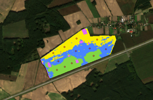
Based on satellite imagery, ScanWorld provides an in-depth analysis of every crop: identifying the zones with consistent SOC levels (coloured zones) based on which an optimal choice of the positions where to take soil samples can be made (red circles, as an example). Copyright: ScanWorld. Satellite imagery from Copernicus’ Sentinel 2
ScanWorld has entered into a collaboration with Australian company CarbonSync to produce computer models that can transform how carbon farmers work by providing local information on a global scale. The models bring simple and affordable tools to farmers and agronomists allowing informed decisions to be made locally, helping farmers identify areas on their land where sampling would be most beneficial, minimising the number they need to take, increasing efficiency and reducing costs.
“The breakthrough we are aiming for is to build models for each individual farm, a trove of information so that your decisions can be supported by data generated on your farm,” says CarbonSync’s CEO, Louise Edmonds. “Satellite-based imagery has been on our radar for a long time, but we have found it hard to bridge the gap between the data and the need for actionable insights for the farmers. ScanWorld’s team was a great partner to tackle this challenge.”
In addition to their work with agriculture, ScanWorld also supports other markets and activities including environmental monitoring, energy leak detection and mining.
A Belgian start-up company, supported by ESA Space Solutions, is researching ways to use satellite imagery to help increase the amount of carbon held in soil, in turn significantly reducing the effects of climate change wrought by agriculture. ScanWorld will use the data gathered to help the new breed of carbon farmers speed up the process of soil sampling, reducing their costs and increasing carbon capture.