
Objectives of the service
Use a bold image to start your webpage. It can be a photo or an infographic like this. Remember that you project webpage can be a powerful marketing tool.
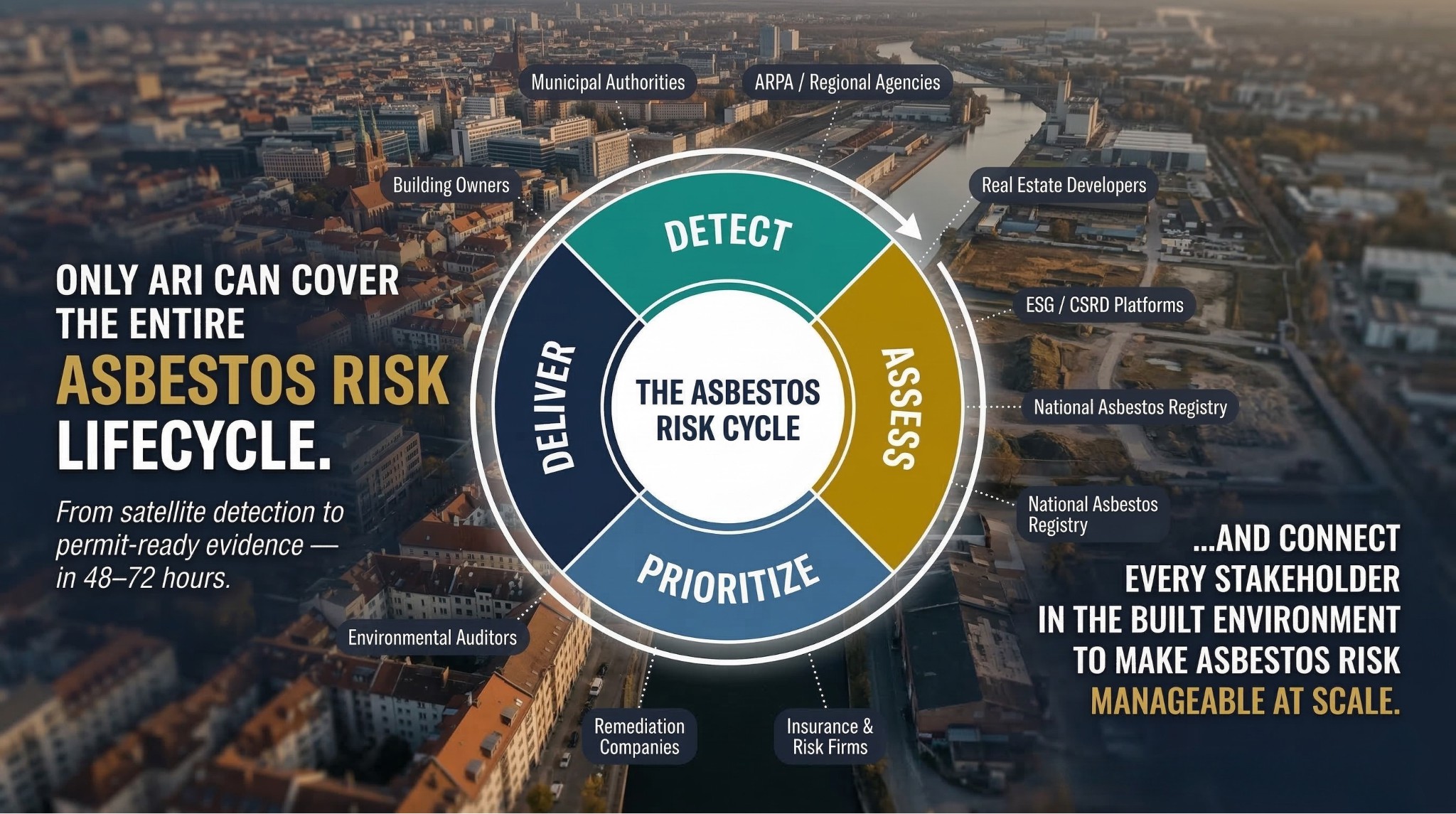
Addressing legacy asbestos remains a critical public health and environmental challenge. Public authorities and real-estate owners face mounting pressure to manage hazardous materials, regenerate brownfields, and prove ESG/regulatory compliance with limited budgets. Current survey practices, such as drone/VHR-only campaigns or "boots-on-the-ground" inspections, are slow, costly, and hard to scale. ARI delivers a space-enabled screening tool that flips the economics to a rapid "breadth-then-depth" approach. By combining satellite-derived probability mapping with
multi-hazard models, specifically earthquakes, floods, and windstorms, ARI calculates a Composite Priority Index (CPI) at the asset level. This provides users with confidence-scored maps, change alerts, and permit-ready evidence cards, enabling stakeholders to proactively identify high-risk sites and optimize field inspection budgets.
Users and their needs
The targeted user communities are primarily based in Italy, with validation scaling toward the broader European municipal and green finance sectors.
-
Municipalities and Regional Agencies (e.g., Naples, Ischia, ARPA Campania): they need objective prioritization of inspections, continuous remote infrastructure assessment, and faster, auditable permit workflows.
-
Real-Estate Developers and Asset Owners (e.g., Engineering2K): they require
transaction-grade evidence to reduce due-diligence cycle times and verifiable environmental compliance reporting for ESG/CSRD standards.
A shared major challenge across these groups is the fragmentation of data and the prohibitive costs and delays associated with physical site verifications.
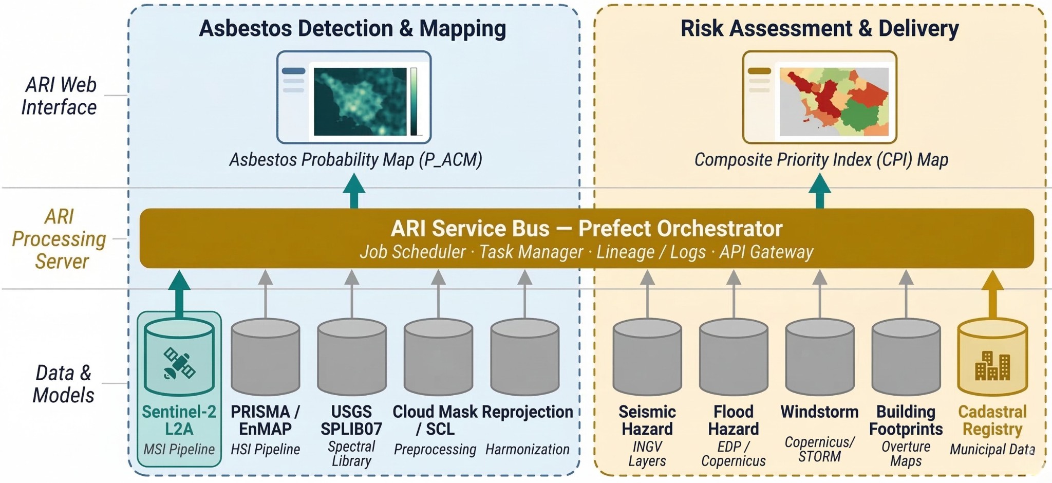
Service/ system concept
Delivered as a native module of the EarthDataInsights platform, ARI provides users with asbestos probability maps, multi-hazard risk layers, and automated PDF Evidence Cards compliant with regulations like D.M. 06/09/1994. The cloud-native system architecture features distinct modular pipelines:
-
Data Acquisition: Automated ingestion of multi-sensor satellite imagery (Sentinel, PRISMA, EnMAP) and hazard datasets (seismic, wind, flood).
-
Analytics Engine: Employs an Ensemble AI Meta-Classifier and spectral matching algorithms (SAM, ACE) against reference spectra (USGS SPLIB07) to compute a per-pixel asbestos probability.
-
Compositor & Delivery: Spatially fuses the probability map with hazard surfaces and exposure data to compute the asset-level Composite Priority Index (CPI). Outputs are accessible via a web dashboard and REST APIs, featuring a "Human-in-the-Loop" workflow for certified digital approval.
Space Added Value
Earth Observation is central to ARI's "breadth-then-depth" screening model, allowing jurisdiction-wide monitoring at a fraction of the cost of commercial drone campaigns.
-
Multispectral & SAR: Copernicus Sentinel-2 and Sentinel-1 provide continuous, high-revisit base data for roof cover mapping and temporal change detection.
-
Hyperspectral Data: Spaceborne hyperspectral missions, specifically ASI's PRISMA and DLR's EnMAP, supply the critical Short-Wave Infrared (SWIR) signatures required for the high-confidence chemical identification of asbestos-cement minerals.
-
Space-derived Hazards: Models like the Copernicus Global DEM and Copernicus European Windstorm reanalysis provide standardized historical tracks and footprints for multi-hazard risk fusion.
Current Status
Use photos, maps or screen grabs in this section.

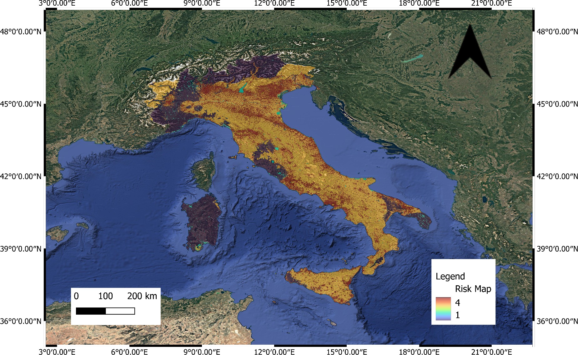

The ARI feasibility study has successfully mapped detailed user requirements through co-design workshops with anchor stakeholders, including the Municipality of Naples and ARPA Campania. The technical feasibility of the core components has been confirmed: the Sentinel-2 multispectral baseline is operational, flood data ingestion is active, and the integration architecture for hyperspectral tasking (PRISMA/EnMAP) has been formally defined. The project has also established the logical flow for the Compositor Engine to calculate the Composite Priority Index (CPI). Currently, the development is focused on finalizing the "Evidence Card" reporting generator and REST API integrations to prepare the service for pre-operational piloting and European commercial scaling.
