
Objectives of the service
Insurers, reinsurers, brokers and industrial risk managers, face persistent challenges in assessing and monitoring exposure to natural catastrophes. Existing solutions are often costly, uneven geographic coverage, and insufficiently precise at site level. They also rely heavily on historical declarations, public records and fragmented datasets, which limits their usefulness for underwriting, prevention and continuous risk monitoring, particularly in remote areas or rapidly evolving situations.
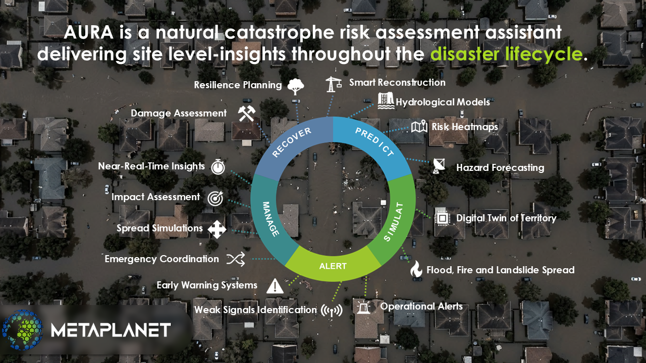
AURA aims to address these limitations by converting Earth Observation (EO) data into insurance-ready natural catastrophe (NATCAT) intelligence focused on floods, wildfires, and landslides. The main service it would provide is site- and building-level exposure analysis, risk scoring, and continuous monitoring of natural catastrophe exposure using satellite data, geospatial processing, and AI models. This would enable users to assess current exposure and detect changes over time, even weak signals, supporting more informed underwriting and risk management decisions.
AURA will deliver a unified service that automates EO data processing and transforms it into actionable outputs, such as NATCAT exposure scores, monitoring alerts, risk maps and site-level evidence layers. The service is intended to support underwriting, prevention, portfolio follow-up and crisis preparedness by providing objective, scalable and regularly updated risk intelligence.
Users and their needs
The service targets insurers, reinsurers, brokers, industrial risk managers, risk experts, and crisis-management teams involved in natural-catastrophe exposure assessment, underwriting, prevention, and monitoring. These users need to assess the vulnerability of sites and portfolios, monitor changes over time, and react more effectively to evolving hazard conditions. Current prospects are located in France and North Africa, mainly Morocco.
User needs
-
Reliable and regularly updated information on exposure to floods, wildfires, and landslides
-
Site- and building-level NATCAT analysis supporting underwriting and prevention
-
Faster and more objective risk assessment without systematic field visits
-
Continuous monitoring of changes affecting exposure and vulnerability
-
Easy-to-integrate outputs for risk, insurance, and portfolio workflows
-
Transparent and defensible indicators supporting operational decision-making
Challenges for the project
-
Delivering NATCAT intelligence that is precise, timely, and affordable
-
Ensuring robust EO- and AI-based models across diverse geographies and industrial contexts
-
Combining satellite data, geospatial layers, and historical information into consistent insurance-ready outputs
-
Maintaining scalable and regular monitoring capabilities
-
Designing interfaces and workflows aligned with underwriting and risk-management practices
-
Building user trust through transparent, explainable, and validated outputs
Service/ system concept
AURA is a geospatial risk intelligence service for insurers, risk experts and industrial site operators. It delivers site- and building-level exposure analysis for floods, wildfires and landslides, together with continuous monitoring, change detection and configurable alerts when risk conditions worsen. Once deployed, the service enables users to assess sites faster, monitor portfolios continuously, compare locations, and support underwriting, prevention and crisis preparation with clearer and more up-to-date evidence.
But how does the system work?
In simple terms, it collects satellite and environmental data, organises it into a live digital picture of each site, and uses artificial intelligence to detect hazard signals, estimate exposure and update risk scores. A central software layer then turns these results into plain-language answers, maps or data services that can be viewed in the platform or integrated directly into customer systems.
Space Added Value
AURA would utilise a variety of space-based assets, including high- and low-resolution optical satellites, radar (SAR) satellites, thermal imaging satellites and multispectral/hyperspectral sensors. Optical imagery provides detailed views of buildings, infrastructure, and environmental conditions. SAR offers all-weather, day-and-night imaging, ensuring continuous monitoring even during storms, floods or smoke. Thermal sensors can detect overheating, fires, and equipment malfunctions, while multispectral data can identify vegetation stress.
Combining these space assets adds value by enabling the delivery of frequent, objective, and consistent information at scale — something that traditional ground inspections, drones, or isolated datasets cannot provide. Unlike manual expert visits, satellite data enables rapid assessments to be made across thousands of sites simultaneously, anywhere in the world, with no operational delays. Competitors who rely solely on optical or public datasets have limited coverage, slower refresh rates and reduced accuracy in challenging conditions.
By fusing optical, radar, thermal and spectral data, AURA creates a richer, more reliable picture of risk exposure and changes over time. This multi-sensor approach dramatically improves exposure assessment, change detection, and early warning capabilities. It enables insurers and risk managers to make faster and more informed decisions than they can with current fragmented or single-source methods.
Current Status
Picture of MetaPlanet’s earth agent able to detect fires on opticla satellite images.
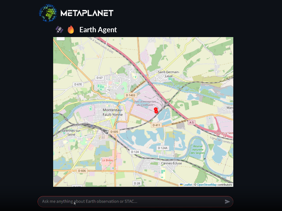
MetaPlanet presented the AURA prototype at three conferences. The first conference in Compiègne was attended by insurers, reinsurers and crisis-response experts, and the second industrial risk conference in Casablanca was attended by about 100 risk professionals, lastly the risk management fair by AMRAE fair in Deauville gathered more than 3000 participants. In total we have had about 70 exchanges with risk professionals. The team ran targeted exchanges with risk service providers, insurers, risk experts, solution integrators and product manufacturers, plus a detailed survey with eight professionals and four follow-up interviews. These activities narrowed the initial scope of a broad GEO AI risk intelligence service to a NatCat-focused service covering floods, wildfires and landslides. A first EO/AI processing pipeline has been prototyped and model training is underway. At this stage we are able to detect fires and river masks on satellite images The next step is to launch first pilot projects and integration discussions with four qualified prospects.
